1950s Maps of Brown County, Texas
Explore 7 historic maps of Brown County from the 1950s. These maps offer a rare glimpse into what life looked like during the 1950s — showing old roads, neighborhoods, homes, and landmarks that have changed or disappeared over time.
Whether you're researching your family's past, planning a metal detecting trip, or studying how Brown County's landscape evolved across the 1950s, these high-resolution maps are a powerful tool for exploring the history of this region.
- Focus on a specific era: All maps on this page are from the 1950s, giving you a focused view of this time period.
- See what’s changed: Compare century-old streets, trails, and buildings to today's modern landscape using overlays and satellite layers.
- Research with precision: Use these maps for genealogy, historical research, land use analysis, or educational projects.
- View, download, or print: Maps are fully viewable online in high resolution, and can be downloaded or printed for your own records.
Start exploring Brown County's history through authentic maps from the 1950s. This is your window into the past.
Brown County, TX maps
(7)- 1950 Map of Zephyr
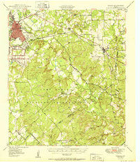 1950 Zephyr1950 Print · USGSBrownwood and the surrounding central Texas countryside are shown at a pivotal mid-century moment as the military and rail industries shaped the local economy. Researchers can locate the sprawling Camp Bowie Military Reservation, find local burial sites like Indian Creek Cemetery, and trace the path of the Santa Fe railroad.2 unique versions available
 - 1950 Map of Mercury
 1950 Mercury1950 Print · USGSMcCulloch County and its neighbors are shown in the mid-twentieth century as the rural landscape transitioned from pioneer roots to modern ranching. Researchers can trace family history through community sites like Cowboy Cemetery, Elm Grove School, and the village of Mercury.2 unique versions available
 - 1950 Map of Mullin
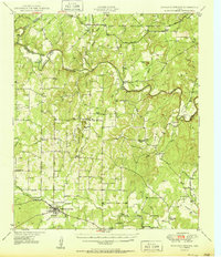
 1950 Mullin1950 Print · USGSThe crossroads of Mills and Brown counties come into focus at the mid-century, centered on the rail hub of Mullin. Researchers can trace old family sites and rural institutions like Williams Ranch, Rock Springs Cem, and the Villa Siding railroad stop.2 unique versions available
 - 1950 Map of Richland Springs
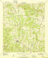
 1950 Richland Springs1950 Print · USGSRichland Springs and the surrounding San Saba ranch lands are captured here at mid-century, just as the regional rail and river network reached its mature form. Genealogists can locate family landmarks like Varga Chapel, Old Algerita Cemetery, and China Creek School.
 - 1954 Map of Brownwood, 1955 Print
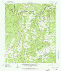
 1954 Brownwood1955 Print · USGSCentral Texas in the early fifties shows a landscape of rail-linked cattle towns and winding river valleys before modern highway expansion. Genealogists and historians can trace family-named peaks and vanished rail stops like Trickham, Santa Anna, and the Brady Mountains.3 unique versions available
 - 1954 Map of Abilene, 1966 Print
 1954 Abilene1966 Print · USGSThe Texas Big Country comes into focus in the mid-1950s as petroleum and new water projects reshape the landscape. Local historians can trace the Butterfield Trail, find the Fort Phantom Hill Ruins, and locate numerous small communities along the Texas & Pacific line.2 unique versions available
 - 1958 Map of Abilene
 1958 Abilene1958 Print · USGSMid-century West Texas comes alive in this survey of the Abilene and Stephenville region during a period of steady oil expansion and military growth. Genealogists and local historians can trace the paths of the Texas & Pacific RR through historic towns, locate the Fort Griffin Ruins, and find smaller settlements like Desdemona and Lueders.
End of results
Showing maps 1-7 of 7
Top cities of Brown County
Frequently asked questions
- What are the different types of historical maps available for Brown County?
- What is the oldest map of Brown County?
- Where can I purchase historical maps of Brown County for my home or office?
- Where can I download high-res historical maps of Brown County?
- Are there historical topographic maps available for Brown County?
- Is there historical aerial imagery available for Brown County?
- Where are historical maps of Brown County sourced from?