1980s Maps of Brown County, Texas
Explore 8 historic maps of Brown County from the 1980s. These maps offer a rare glimpse into what life looked like during the 1980s — showing old roads, neighborhoods, homes, and landmarks that have changed or disappeared over time.
Whether you're researching your family's past, planning a metal detecting trip, or studying how Brown County's landscape evolved across the 1980s, these high-resolution maps are a powerful tool for exploring the history of this region.
- Focus on a specific era: All maps on this page are from the 1980s, giving you a focused view of this time period.
- See what’s changed: Compare century-old streets, trails, and buildings to today's modern landscape using overlays and satellite layers.
- Research with precision: Use these maps for genealogy, historical research, land use analysis, or educational projects.
- View, download, or print: Maps are fully viewable online in high resolution, and can be downloaded or printed for your own records.
Start exploring Brown County's history through authentic maps from the 1980s. This is your window into the past.
Brown County, TX maps
(8)- 1980 Map of Bowser
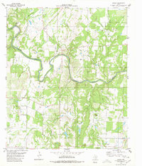 1980 Bowser1980 Print · USGSThe Colorado River corridor near the San Saba and Mills County line comes to life in this mid-1970s study. Genealogists and local historians can trace family ties at Vargy Chapel, Oakland Church, and the Bowser Cemetery near the old Bowser settlement.
 - 1980 Map of Brownwood
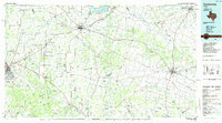
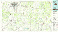
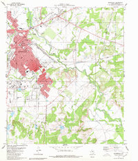 1980 Brownwood1980 Print · USGSThe rail-and-river hub of Brownwood is documented here in the early eighties as it expanded toward Early and Ricker. Local historians can trace the limits of the Camp Bowie Military Reservation, find the Connell Cem, and locate landmarks like the MacArthur Acad of Freedom.2 unique versions available
 - 1985 Map of Coleman
 1985 Coleman1985 Print · USGSCentral Texas ranching and rail country comes to life in the 1980s as the Atchison Topeka and Santa Fe line cuts through Coleman. Researchers can trace old settlements and topography from Robinson Peak to the waters of Lake Brownwood State Park.2 unique versions available
 - 1985 Map of Stephenville
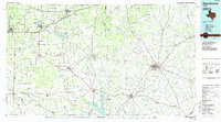 1985 Stephenville1985 Print · USGSNorth Central Texas in the mid-eighties shows a landscape defined by ranching, rail history, and early oil towns. Genealogists and historians can trace the paths of the Texas Central railroad and locate rural communities like Desdemona, Lingleville, and Punkin Center.2 unique versions available
 - 1985 Map of Brady
 1985 Brady1985 Print · USGSMcCulloch and Concho counties during the mid-1980s show a landscape of small ranching communities tied together by the Atchison Topeka and Santa Fe rail line. Researchers can trace rural developments like West Sweden, Pear Valley, and the waters of the Brady Reservoir.2 unique versions available
 - 1985 Map of San Saba
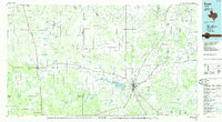
 1985 San Saba1985 Print · USGSCentral Texas in the mid-eighties was a landscape of river-valley ranching and quiet railroad towns. Researchers can trace family history through sites like San Saba Cem, follow the Atchison Topeka and Santa Fe line, or explore landmarks near Pecan Bayou.2 unique versions available
 - 1985 Map of Comanche
 1985 Comanche1985 Print · USGSCentral Texas in the mid-eighties shows a landscape of established ranching towns and expanding reservoirs. Trace the family-named gaps and summits from Mercers Gap to Hog Mountains, alongside smaller settlements like Gentrys Mill and Hazeldell.2 unique versions available
 - 1985 Map of Abilene, 1986 Print
 1985 Abilene1986 Print · USGSThe West Texas ranching and rail landscape around Abilene is captured here in the mid-1980s. Local researchers can trace the growth of Hardin-Simmons University, locate family sites near Ross Cem, or explore the area around Buffalo Gap and Dyess Air Force Base.2 unique versions available
End of results
Showing maps 1-8 of 8
Top cities of Brown County
Frequently asked questions
- What are the different types of historical maps available for Brown County?
- What is the oldest map of Brown County?
- Where can I purchase historical maps of Brown County for my home or office?
- Where can I download high-res historical maps of Brown County?
- Are there historical topographic maps available for Brown County?
- Is there historical aerial imagery available for Brown County?
- Where are historical maps of Brown County sourced from?