1800s (19th Century) Maps of Callahan County, Texas
Explore 6 historic maps of Callahan County from the 1800s (19th Century). These maps offer a rare glimpse into what life looked like during the 1800s — showing old roads, neighborhoods, homes, and landmarks that have changed or disappeared over time.
Whether you're researching your family's past, planning a metal detecting trip, or studying how Callahan County's landscape evolved across the 1800s, these high-resolution maps are a powerful tool for exploring the history of this region.
- Focus on a specific era: All maps on this page are from the 1800s, giving you a focused view of this time period.
- See what’s changed: Compare century-old streets, trails, and buildings to today's modern landscape using overlays and satellite layers.
- Research with precision: Use these maps for genealogy, historical research, land use analysis, or educational projects.
- View, download, or print: Maps are fully viewable online in high resolution, and can be downloaded or printed for your own records.
Start exploring Callahan County's history through authentic maps from the 1800s. This is your window into the past.
Callahan County, TX maps
(6)- 1890 Map of Abilene, 1955 Print
 1890 Abilene1955 Print · USGSWest Texas ranching country and rail settlements come alive in the 1890s as the railroad transforms the prairie. Genealogists can trace early homesteads near Buffalo Gap or follow the Texas and Pacific Railway through Abilene and Elmdale.
 - 1891 Map of Anson
 1891 Anson1891 Print · USGSJones County was still a frontier of small settlements and river crossings in the early 1890s. Genealogists and researchers can trace the early footprints of Anson alongside forgotten locales like Sandersville, Phantom Hill, and Rising Sun.
 - 1892 Map of Abilene
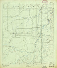
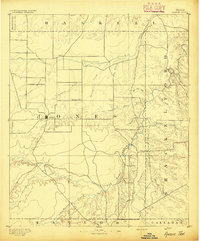
 1892 Abilene1892 Print · USGSTaylor and Callahan counties were transitioning into a major rail and ranching corridor during the 1890s. Genealogical researchers can locate early frontier settlements like Buffalo Gap and Guion, or trace the path of the Texas and Pacific Railway.5 unique versions available
 - 1892 Map of Albany
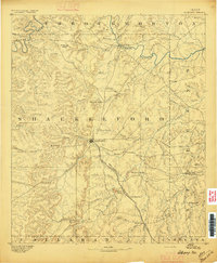
 1892 Albany1892 Print · USGSShackelford County in the late 1880s was a landscape of emerging rail lines and river outposts. Local historians can trace the early path of the Texas Central Railroad through Albany and locate early landmarks like Fort Griffen and Mankins Mill.
 - 1893 Map of Albany
 1893 Albany1893 Print · USGSShackelford County and the surrounding cattle country are captured in the late nineteenth century during the expansion of the Texas Central Railroad. Researchers can locate the frontier site of Fort Griffen, early schools like Shady Grove Ch., and the milling operations at Mankins Mill.5 unique versions available
 - 1893 Map of Anson
 1893 Anson1893 Print · USGSCentral West Texas in the early 1890s shows a landscape of cattle ranches and early outposts. Genealogists can locate family-named settlements like Sandersville and Newsom or trace the early community at Phantom Hill.5 unique versions available
End of results
Showing maps 1-6 of 6
Top cities of Callahan County
Frequently asked questions
- What are the different types of historical maps available for Callahan County?
- What is the oldest map of Callahan County?
- Where can I purchase historical maps of Callahan County for my home or office?
- Where can I download high-res historical maps of Callahan County?
- Are there historical topographic maps available for Callahan County?
- Is there historical aerial imagery available for Callahan County?
- Where are historical maps of Callahan County sourced from?