1900s (20th Century) Maps of Callahan County, Texas
Explore 38 historic maps of Callahan County from the 1900s (20th Century). These maps offer a rare glimpse into what life looked like during the 1900s — showing old roads, neighborhoods, homes, and landmarks that have changed or disappeared over time.
Whether you're researching your family's past, planning a metal detecting trip, or studying how Callahan County's landscape evolved across the 1900s, these high-resolution maps are a powerful tool for exploring the history of this region.
- Focus on a specific era: All maps on this page are from the 1900s, giving you a focused view of this time period.
- See what’s changed: Compare century-old streets, trails, and buildings to today's modern landscape using overlays and satellite layers.
- Research with precision: Use these maps for genealogy, historical research, land use analysis, or educational projects.
- View, download, or print: Maps are fully viewable online in high resolution, and can be downloaded or printed for your own records.
Start exploring Callahan County's history through authentic maps from the 1900s. This is your window into the past.
Callahan County, TX maps
(38)- 1931 Map of Baird
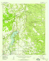
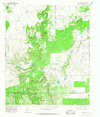
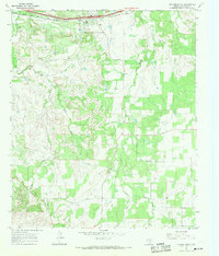
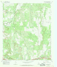
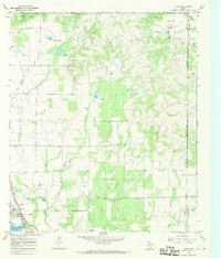
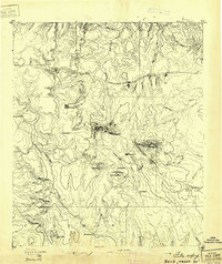 1931 Baird1931 Print · USGSCallahan County ranching and rail life are documented here in the early twentieth century. Genealogists and local historians can trace the foundations of Baird, the Rough Creek P.O., and distinctive landmarks like Caddo Peak and Round Mt.
 - 1932 Map of Baird
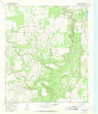
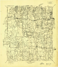 1932 Baird1932 Print · USGSCallahan and Eastland counties appear in the early 1930s, showing the region's transition into the oil and highway era. Genealogists can locate family homes near Belle Plain, Oak Ridge School, and along the Missouri Kansas & Texas railroad.
 - 1954 Map of Abilene, 1966 Print
 1954 Abilene1966 Print · USGSThe Texas Big Country comes into focus in the mid-1950s as petroleum and new water projects reshape the landscape. Local historians can trace the Butterfield Trail, find the Fort Phantom Hill Ruins, and locate numerous small communities along the Texas & Pacific line.2 unique versions available
 - 1957 Map of Kirby Lake, 1958 Print
 1957 Kirby Lake1958 Print · USGSAbilene was expanding toward the eastern oil fields and southern ranch lands in the late fifties. Genealogists can trace family names at the Potosi Cem and Eula Cem, or locate earlier rural landmarks like the Denton Sch (Aban'd) and Potosi Sch (Aban'd).2 unique versions available
 - 1957 Map of Abilene East, 1958 Print
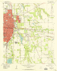 1957 Abilene East1958 Print · USGSAbilene emerges as a flourishing West Texas educational and medical center in the mid-fifties. Researchers can trace the footprints of Hardin-Simmons University, the old Airport (Aban'd), and the grounds of the West Texas Fairground.4 unique versions available
 - 1957 Map of Nugent, 1958 Print
 1957 Nugent1958 Print · USGSThe West Texas ranchlands and oil fields of Jones and Taylor counties are captured here in the late fifties. Genealogists and local historians can trace the foundations of Hamby, the Fort Phantom Hill ruins, and family landmarks like the Davis Ranch.
 - 1957 Map of Hamby, 1958 Print
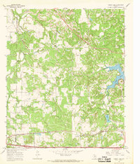
 1957 Hamby1958 Print · USGSThe West Texas plains northeast of Abilene are captured here in the late fifties as water infrastructure transformed the landscape. Trace the shores of Lake Fort Phantom Hill and find local landmarks like the Drive-in Theater and the community of Hamby.4 unique versions available
 - 1958 Map of Abilene
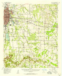
 1958 Abilene1958 Print · USGSMid-century West Texas comes alive in this survey of the Abilene and Stephenville region during a period of steady oil expansion and military growth. Genealogists and local historians can trace the paths of the Texas & Pacific RR through historic towns, locate the Fort Griffin Ruins, and find smaller settlements like Desdemona and Lueders.
 - 1960 Map of Cross Cut, 1962 Print
 1960 Cross Cut1962 Print · USGSMid-century Texas oil and ranching land come into focus here during the early 1960s. Genealogists and industrial historians can trace the Old Railroad Grade or locate family sites near Dressy Cem and the small community of Cross Cut.2 unique versions available
 - 1960 Map of Webbville, 1962 Print
 1960 Webbville1962 Print · USGSThe West Texas landscape at the start of the 1960s reveals a region defined by cattle country and petroleum extraction. Trace local history through the Anzah Morris Oil Field, the settlement of Webbville, and the Adams Cem along the disputed county line.2 unique versions available
 - 1960 Map of Crooked Creek, 1962 Print
 1960 Crooked Creek1962 Print · USGSTexas ranching and oil country come to life in the early 1960s along the winding paths of Jim Ned Creek and Crooked Creek. Researchers can trace old property lines across the 1885 county boundary survey while locating numerous Oil Wells and a Quarry in the hills near Ranger.2 unique versions available
 - 1965 Map of Snyder Lake, 1967 Print
 1965 Snyder Lake1967 Print · USGSThe Shackelford and Callahan county line in the mid-1960s is characterized by an active petroleum economy and ranching lands. Researchers can trace the extensive OIL FIELD operations and natural water features like Snyder Lake and Hubbard Creek.2 unique versions available
 - 1965 Map of Indian Knoll, 1967 Print
 1965 Indian Knoll1967 Print · USGSThe West Texas rangelands at the crossroads of Stephens and Eastland counties come into focus in the mid-1960s. Genealogists and researchers can trace family-named sites like Graves and explore the industrial footprint of Eureka and the Compressor Sta.
 - 1965 Map of Moran, 1968 Print
 1965 Moran1968 Print · USGSThe West Texas landscape around the Shackelford and Callahan county line is captured here in the mid-1960s, showing a region defined by petroleum and rail. Researchers can trace the Missouri Kansas Texas line, the Oil Field at Sedwick, and old burial grounds like Johnson Cem.
 - 1965 Map of Leeper Creek, 1968 Print
 1965 Leeper Creek1968 Print · USGSThe West Texas ranchlands on the Shackelford and Callahan county line are captured here in the mid-1960s. Genealogists and researchers can trace early energy development through numerous Oil Wells and pipelines near Leeper Creek and Deadman Draw.2 unique versions available
 - 1966 Map of Scranton, 1969 Print
 1966 Scranton1969 Print · USGSAcross the Eastland County ranchlands in the mid-1960s, rural life centered on small communities and family burial grounds. Researchers can trace local lineages at Pisgah Cem and Haskell Cem or explore the early settlements of Scranton and Nimrod.2 unique versions available
 - 1966 Map of Putnam South, 1969 Print
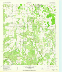
 1966 Putnam South1969 Print · USGSCallahan County's rural landscape is defined by the energy and rail industries in the mid-1960s. Genealogists and researchers can trace the settlement at Putnam, locate remote Oil Wells, and follow the path of the Texas and Pacific railroad.2 unique versions available
 - 1966 Map of Baird, 1969 Print
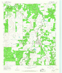
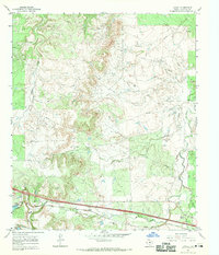
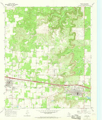 1966 Baird1969 Print · USGSCallahan County's rail and road corridor comes into focus in the 1960s as INTERSTATE 20 parallels the Texas and Pacific line. Genealogists and local historians can trace the foundations of Clyde and Baird, locating the St Joachim Cem and the community Rodeo Ground.2 unique versions available
 - 1966 Map of Bernie Lake, 1969 Print
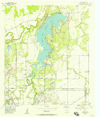
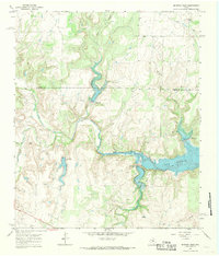
 1966 Bernie Lake1969 Print · USGSThe West Texas borderlands of Callahan and Eastland Counties are shown here during the mid-sixties, dominated by a network of creeks and early industrial infrastructure. Researchers can trace the Texas and Pacific line, locate Dothan Cem, and explore the shoreline of Lake Cisco.
 - 1966 Map of Admiral, 1969 Print
 1966 Admiral1969 Print · USGSCallahan County's early frontier history remains visible in the mid-1960s, centered on the remains of a once-bustling county seat. Genealogists and historians can trace the Belle Plain Cem, locate the site of ruins, and find the remote settlement of Admiral.2 unique versions available
 - 1966 Map of Putnam North, 1969 Print
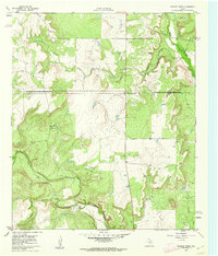
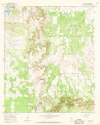
 1966 Putnam North1969 Print · USGSCallahan County in the mid-sixties reveals a working landscape of ranching and oil production north of the settlement of Putnam. Researchers can trace the Old Railroad Grade, locate the Hart Cem, and follow the winding courses of Deep Creek and Battle Creek.
 - 1966 Map of Cub Hollow, 1970 Print
 1966 Cub Hollow1970 Print · USGSCallahan County in the mid-1960s reveals a landscape shaped by petroleum extraction and ranching drainage. Local researchers can trace the settlement at Todd, explore industrial sites near Baird Lake, and follow the winding North Prong Pecan Bayou.3 unique versions available
 - 1966 Map of Jayell, 1970 Print
 1966 Jayell1970 Print · USGSCallahan County in the mid-1960s reveals an landscape defined by the Texas and Pacific railroad and a burgeoning petroleum industry. Researchers can trace the layout of the Jayell settlement and locate industrial markers like the local Refinery and various Oil Fields.
 - 1967 Map of McEwen Draw, 1969 Print
 1967 McEwen Draw1969 Print · USGSThe Callahan and Coleman County borderlands come into focus in the late sixties as the local landscape is reshaped by water and oil. Trace family history at the Jim Ned Cem and explore the early footprint of Lake Coleman.2 unique versions available
 - 1967 Map of Lawn, 1970 Print
 1967 Lawn1970 Print · USGSLawn and the Taylor-Callahan county line are captured here in the late sixties, showing a period of rural industry and community life. Researchers can locate the Cope Cem, trace the A T AND S F railroad, or find mid-century landmarks like the local Drive-in Theater.2 unique versions available
Showing maps 1-25 of 38
Top cities of Callahan County
Frequently asked questions
- What are the different types of historical maps available for Callahan County?
- What is the oldest map of Callahan County?
- Where can I purchase historical maps of Callahan County for my home or office?
- Where can I download high-res historical maps of Callahan County?
- Are there historical topographic maps available for Callahan County?
- Is there historical aerial imagery available for Callahan County?
- Where are historical maps of Callahan County sourced from?