1930s Maps of Culberson County, Texas
Explore 3 historic maps of Culberson County from the 1930s. These maps offer a rare glimpse into what life looked like during the 1930s — showing old roads, neighborhoods, homes, and landmarks that have changed or disappeared over time.
Whether you're researching your family's past, planning a metal detecting trip, or studying how Culberson County's landscape evolved across the 1930s, these high-resolution maps are a powerful tool for exploring the history of this region.
- Focus on a specific era: All maps on this page are from the 1930s, giving you a focused view of this time period.
- See what’s changed: Compare century-old streets, trails, and buildings to today's modern landscape using overlays and satellite layers.
- Research with precision: Use these maps for genealogy, historical research, land use analysis, or educational projects.
- View, download, or print: Maps are fully viewable online in high resolution, and can be downloaded or printed for your own records.
Start exploring Culberson County's history through authentic maps from the 1930s. This is your window into the past.
Culberson County, TX maps
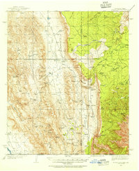
(3)- 1933 Map of Guadalupe Peak
 1933 Guadalupe Peak1933 Print · USGSThe high desert of Culberson County meets the Texas peaks in the 1930s, documenting a landscape of remote ranching outposts and high-altitude mining. Genealogists and historians can trace family-named sites like Ables PO, Williams Ranch, and Sid Ables Well alongside early mountain retreats.6 unique versions available
 - 1935 Map of El Paso Gap, 1954 Print
 1935 El Paso Gap1954 Print · USGSThe Guadalupe Mountains of the mid-thirties are captured here as a landscape of isolated ranching outposts and vital water tanks. Genealogists and historians can trace family homesteads like Thayer Ranch and Carpenter Ranch, or locate the rural schoolhouses at Queen Sch and Dog Canyon Sch.2 unique versions available
 - 1936 Map of El Paso Gap
 1936 El Paso Gap1936 Print · USGSThe high desert ranching frontier along the New Mexico-Texas border is captured here during the mid-1930s. Researchers can locate remote schools and outposts like Queen Sch, the El Paso Gap PO, and family-named landmarks including Thayer Ranch.
End of results
Showing maps 1-3 of 3
Top cities of Culberson County
Frequently asked questions
- What are the different types of historical maps available for Culberson County?
- What is the oldest map of Culberson County?
- Where can I purchase historical maps of Culberson County for my home or office?
- Where can I download high-res historical maps of Culberson County?
- Are there historical topographic maps available for Culberson County?
- Is there historical aerial imagery available for Culberson County?
- Where are historical maps of Culberson County sourced from?