1940s Maps of Culberson County, Texas
Explore 9 historic maps of Culberson County from the 1940s. These maps offer a rare glimpse into what life looked like during the 1940s — showing old roads, neighborhoods, homes, and landmarks that have changed or disappeared over time.
Whether you're researching your family's past, planning a metal detecting trip, or studying how Culberson County's landscape evolved across the 1940s, these high-resolution maps are a powerful tool for exploring the history of this region.
- Focus on a specific era: All maps on this page are from the 1940s, giving you a focused view of this time period.
- See what’s changed: Compare century-old streets, trails, and buildings to today's modern landscape using overlays and satellite layers.
- Research with precision: Use these maps for genealogy, historical research, land use analysis, or educational projects.
- View, download, or print: Maps are fully viewable online in high resolution, and can be downloaded or printed for your own records.
Start exploring Culberson County's history through authentic maps from the 1940s. This is your window into the past.
Culberson County, TX maps
(9)- 1940 Map of El Paso Gap
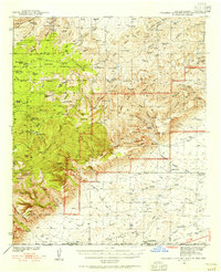
 1940 El Paso Gap1940 Print · USGSThe Guadalupe Mountains of southern New Mexico are shown in the mid-1930s, defined by a network of remote livestock ranches and isolated mountain schools. Genealogists and historians can trace family landholdings at Hepler Ranch or Lewis Ranch and locate vanished local landmarks like Queen Sch and the Old Post Place.3 unique versions available
 - 1940 Map of Guadalupe Peak, 1949 Print
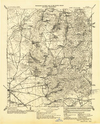
 1940 Guadalupe Peak1949 Print · USGSCulberson County ranching and the high peaks of West Texas are captured here in the decade before the national park's founding. Genealogists and historians can trace family landholdings like Williams Ranch, Hegler Ranch, and the remote settlement at Frijole.2 unique versions available
 - 1940 Map of Carlsbad Caverns West, 1955 Print
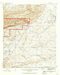
 1940 Carlsbad Caverns West1955 Print · USGSThe Guadalupe Mountains of southern New Mexico are shown here just before the mid-century, revealing a remote ranching and caving landscape. Researchers can trace early family outposts like Able Ranch and Thurman Ranch or locate the numerous karst features such as Mudgetts Cave and Painted Grotto.5 unique versions available
 - 1943 Map of Carlsbad Caverns West
 1943 Carlsbad Caverns West1943 Print · USGSEddy County ranching outposts and the subterranean wonders of the Guadalupe Mountains are captured here in the early 1940s. Genealogists and historians can trace family land at Montgomery Ranch, visit the site of Queen (Ruins), or explore the springs at Sitting Bull Falls.
 - 1943 Map of Valentine
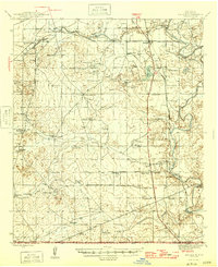
 1943 Valentine1943 Print · USGSValentine and the Davis Mountains come alive in this mid-century look at the cattle and rail country of West Texas. Genealogists and historians can trace family-named holdings like Means Ranch Hdqrs., Prude's Ranch, and the isolated Foster Cabin.
 - 1945 Map of Carlsbad Caverns East, 1961 Print
 1945 Carlsbad Caverns East1961 Print · USGSSoutheast New Mexico in the mid-1940s reveals a rugged landscape of ranching outposts and high desert canyons. Genealogists and researchers can locate family sites like the W W Smith & Sons Ranch, explore the early footprint of White City, or find the Julian Smith Cem.2 unique versions available
 - 1945 Map of Malaga, 1970 Print
 1945 Malaga1970 Print · USGSEddy County ranchlands and river valleys are captured here at the end of the war, as the rail-and-ranch economy shaped southern New Mexico. Genealogists and historians can locate specific family holdings like the Delaware Ranch and Welch Ranch, alongside a vintage Bombing Target.
 - 1946 Map of Malaga
 1946 Malaga1946 Print · USGSSouthern New Mexico ranching and river life are frozen in time just after the war. Researchers can trace family ranch lands like Cottonwood Ranch and Reeves Ranch or locate unique landmarks like the Bombing Target and Harkey Double Mills.
 - 1947 Map of Carlsbad Caverns East
 1947 Carlsbad Caverns East1947 Print · USGSThe Guadalupe Mountains and the high desert of Eddy County are captured here just after the war. Researchers can trace early ranching boundaries and landmarks like White City, the Cavern Entrance, and a remote Bombing Target.
End of results
Showing maps 1-9 of 9
Top cities of Culberson County
Frequently asked questions
- What are the different types of historical maps available for Culberson County?
- What is the oldest map of Culberson County?
- Where can I purchase historical maps of Culberson County for my home or office?
- Where can I download high-res historical maps of Culberson County?
- Are there historical topographic maps available for Culberson County?
- Is there historical aerial imagery available for Culberson County?
- Where are historical maps of Culberson County sourced from?