1910s Maps of Galena Park, Texas
Explore 5 historic maps of Galena Park from the 1910s. These maps offer a rare glimpse into what life looked like during the 1910s — showing old roads, neighborhoods, homes, and landmarks that have changed or disappeared over time.
Whether you're researching your family's past, planning a metal detecting trip, or studying how Galena Park's landscape evolved across the 1910s, these high-resolution maps are a powerful tool for exploring the history of this region.
- Focus on a specific era: All maps on this page are from the 1910s, giving you a focused view of this time period.
- See what’s changed: Compare century-old streets, trails, and buildings to today's modern landscape using overlays and satellite layers.
- Research with precision: Use these maps for genealogy, historical research, land use analysis, or educational projects.
- View, download, or print: Maps are fully viewable online in high resolution, and can be downloaded or printed for your own records.
Start exploring Galena Park's history through authentic maps from the 1910s. This is your window into the past.
Galena Park, TX maps
(5)- 1915 Map of Park Place
 1915 Park Place1915 Print · USGSSoutheast Houston and the thriving ship channel districts are captured here just before the first World War. Genealogists and industrial historians can trace the early residential blocks of Magnolia and Park Place or the rail yards at South Yards.2 unique versions available
 - 1915 Map of Deepwater
 1915 Deepwater1915 Print · USGSSoutheast of Houston during the early twentieth-century boom, this area shows the vital transformation of the coastal prairie into an industrial hub. Trace the early footprints of Pasadena, South Houston, and Genoa alongside the Ship Channel and the Penn City School.
 - 1916 Map of Settegast
 1916 Settegast1916 Print · USGSNortheast Houston was a burgeoning rail and industrial corridor during the mid-1910s, prior to its full integration into the modern metropolis. Genealogists and historians can trace early neighborhood plats like Brooks Smith Addition and Fidelity Addition alongside the massive Tank Farm and local schoolhouses.2 unique versions available
 - 1916 Map of Fauna
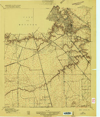
 1916 Fauna1916 Print · USGSHarris County’s coastal prairies are captured here in the early twentieth century, showing a landscape defined by winding bayous and early overland routes. Genealogists and historians can trace family locations near Fauna, Abbots Store, and along the historic Liberty Road.
 - 1919 Map of Deepwater
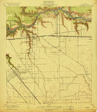 1919 Deepwater1919 Print · USGSHarris County at the height of the early shipping boom shows the transformation of the bayou into an industrial corridor. Trace family roots and early infrastructure in Pasadena and South Houston, or locate the Penn City Ferry and Dumont Sta.2 unique versions available
End of results
Showing maps 1-5 of 5
Top cities near Galena Park
- Houston historical maps
- Pasadena historical maps
- Pearland historical maps
- League City historical maps
- Baytown historical maps
- Channelview historical maps
See more
Frequently asked questions
- What are the different types of historical maps available for Galena Park?
- What is the oldest map of Galena Park?
- Where can I purchase historical maps of Galena Park for my home or office?
- Where can I download high-res historical maps of Galena Park?
- Are there historical topographic maps available for Galena Park?
- Is there historical aerial imagery available for Galena Park?
- Where are historical maps of Galena Park sourced from?