1920s Maps of Galena Park, Texas
Explore 3 historic maps of Galena Park from the 1920s. These maps offer a rare glimpse into what life looked like during the 1920s — showing old roads, neighborhoods, homes, and landmarks that have changed or disappeared over time.
Whether you're researching your family's past, planning a metal detecting trip, or studying how Galena Park's landscape evolved across the 1920s, these high-resolution maps are a powerful tool for exploring the history of this region.
- Focus on a specific era: All maps on this page are from the 1920s, giving you a focused view of this time period.
- See what’s changed: Compare century-old streets, trails, and buildings to today's modern landscape using overlays and satellite layers.
- Research with precision: Use these maps for genealogy, historical research, land use analysis, or educational projects.
- View, download, or print: Maps are fully viewable online in high resolution, and can be downloaded or printed for your own records.
Start exploring Galena Park's history through authentic maps from the 1920s. This is your window into the past.
Galena Park, TX maps
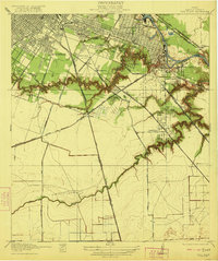
(3)- 1920 Map of Fauna
 1920 Fauna1920 Print · USGSHarris County east of Houston is captured here as a landscape of winding bayous and prairie just after the Great War. Researchers can trace the early footprints of Fauna and Abbots Store or follow the path of the Market Street Road through the bottomlands.
 - 1922 Map of Park Place
 1922 Park Place1922 Print · USGSSoutheastern Harris County is seen here during its industrial transformation in the years following the 1915 survey. Genealogists and researchers can trace early residential tracts like Park Place and Forest Hills or locate old railway sidings such as Sheets Switch and Rambler Switch.3 unique versions available
 - 1922 Map of Settegast
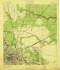 1922 Settegast1922 Print · USGSHouston and its surrounding Harris County townships are captured here during a period of intense industrial growth and residential expansion. Researchers can trace the early footprints of the Brooke-Smith Addition and Settegast, or locate rural landmarks like Berry School and the Tank Farm.2 unique versions available
End of results
Showing maps 1-3 of 3
Top cities near Galena Park
- Houston historical maps
- Pasadena historical maps
- Pearland historical maps
- League City historical maps
- Baytown historical maps
- Channelview historical maps
See more
Frequently asked questions
- What are the different types of historical maps available for Galena Park?
- What is the oldest map of Galena Park?
- Where can I purchase historical maps of Galena Park for my home or office?
- Where can I download high-res historical maps of Galena Park?
- Are there historical topographic maps available for Galena Park?
- Is there historical aerial imagery available for Galena Park?
- Where are historical maps of Galena Park sourced from?