1950s Maps of Galena Park, Texas
Explore 6 historic maps of Galena Park from the 1950s. These maps offer a rare glimpse into what life looked like during the 1950s — showing old roads, neighborhoods, homes, and landmarks that have changed or disappeared over time.
Whether you're researching your family's past, planning a metal detecting trip, or studying how Galena Park's landscape evolved across the 1950s, these high-resolution maps are a powerful tool for exploring the history of this region.
- Focus on a specific era: All maps on this page are from the 1950s, giving you a focused view of this time period.
- See what’s changed: Compare century-old streets, trails, and buildings to today's modern landscape using overlays and satellite layers.
- Research with precision: Use these maps for genealogy, historical research, land use analysis, or educational projects.
- View, download, or print: Maps are fully viewable online in high resolution, and can be downloaded or printed for your own records.
Start exploring Galena Park's history through authentic maps from the 1950s. This is your window into the past.
Galena Park, TX maps
(6)- 1950 Map of Houston, 1953 Print
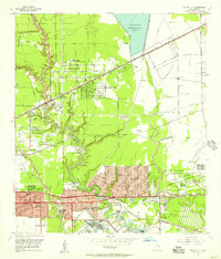
 1950 Houston1953 Print · USGSCoastal Texas in the early fifties reveals a landscape of massive civil engineering and industrial transit. Genealogists and researchers can trace the growth of the Houston suburbs and the maritime infrastructure of Galveston Bay, including the Gulf Freeway and the Texas City Dike.
 - 1955 Map of Park Place, 1957 Print
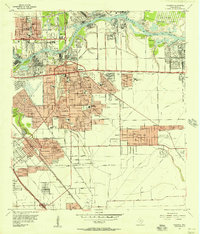
 1955 Park Place1957 Print · USGSSoutheast Houston expanded rapidly during the mid-fifties as shipping and aviation infrastructure matured. Researchers can trace the development of neighborhood hubs like Park Place, the sprawling Houston International Airport, and dozens of local schools including Yates High Sch.
 - 1955 Map of Jacinto City, 1957 Print
 1955 Jacinto City1957 Print · USGSEast of Houston in the mid-fifties, this area shows a landscape of rising suburbs and industrial infrastructure along Greens Bayou. Researchers can trace the development of Cloverleaf, find the Harris County Cem, and locate the sprawling San Jacinto Ordnance Depot.
 - 1955 Map of Settegast, 1957 Print
 1955 Settegast1957 Print · USGSNortheast Houston transitioned from residential pockets to a massive rail and industrial corridor during the mid-fifties. Genealogists and historians can locate dozens of neighborhood landmarks, including Settegast Yards, Settegast Sch, and Hollywood Cemetery.
 - 1955 Map of Pasadena, 1957 Print
 1955 Pasadena1957 Print · USGSSoutheast Texas industrial growth is on full display during the mid-fifties as the ship channel corridor rapidly expands. Genealogists and researchers can trace neighborhood development near Pasadena schools or find the footprint of the San Jacinto Ordnance Depot.
 - 1956 Map of Houston, 1963 Print
 1956 Houston1963 Print · USGSSoutheast Texas in the mid-fifties is captured here as a powerhouse of oil and maritime trade. Genealogists and historians can trace the foundations of Houston and its ports, alongside landmarks like the Rice Institute and the Spindletop Oil Field.2 unique versions available
End of results
Showing maps 1-6 of 6
Top cities near Galena Park
- Houston historical maps
- Pasadena historical maps
- Pearland historical maps
- League City historical maps
- Baytown historical maps
- Channelview historical maps
See more
Frequently asked questions
- What are the different types of historical maps available for Galena Park?
- What is the oldest map of Galena Park?
- Where can I purchase historical maps of Galena Park for my home or office?
- Where can I download high-res historical maps of Galena Park?
- Are there historical topographic maps available for Galena Park?
- Is there historical aerial imagery available for Galena Park?
- Where are historical maps of Galena Park sourced from?