1960s Maps of Kimble County, Texas
Explore 8 historic maps of Kimble County from the 1960s. These maps offer a rare glimpse into what life looked like during the 1960s — showing old roads, neighborhoods, homes, and landmarks that have changed or disappeared over time.
Whether you're researching your family's past, planning a metal detecting trip, or studying how Kimble County's landscape evolved across the 1960s, these high-resolution maps are a powerful tool for exploring the history of this region.
- Focus on a specific era: All maps on this page are from the 1960s, giving you a focused view of this time period.
- See what’s changed: Compare century-old streets, trails, and buildings to today's modern landscape using overlays and satellite layers.
- Research with precision: Use these maps for genealogy, historical research, land use analysis, or educational projects.
- View, download, or print: Maps are fully viewable online in high resolution, and can be downloaded or printed for your own records.
Start exploring Kimble County's history through authentic maps from the 1960s. This is your window into the past.
Kimble County, TX maps
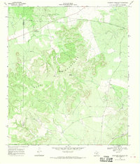
(8)- 1962 Map of Hill Ranch, 1965 Print
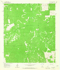 1962 Hill Ranch1965 Print · USGSTexas ranching culture is well-documented in this early 1960s survey of the Kimble and Edwards County lines. Genealogists can locate specific family lands like Cardwell Ranch, Nethery Ranch, and Jetton Ranch along the waters of Knust Draw.2 unique versions available
 - 1962 Map of Roosevelt, 1966 Print
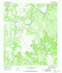
 1962 Roosevelt1966 Print · USGSThe Texas Hill Country ranching landscape comes into focus during the early sixties, centered on the settlement of Roosevelt. Genealogists and historians can trace family landholdings like Maynard Ranch and Wilson Place along the banks of the North Llano River.2 unique versions available
 - 1963 Map of McKegan Draw, 1966 Print
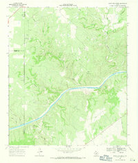
 1963 McKegan Draw1966 Print · USGSKimble and Sutton Counties are captured here in the early sixties, showing a landscape defined by large family holdings and the headwaters of the Llano River. Genealogists and historians can trace the boundaries of the Chadwick Ranch, locate the remote Joy Ranch, and follow the path of Copperas Creek.
 - 1963 Map of McKegan Draw NE, 1966 Print
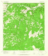
 1963 McKegan Draw NE1966 Print · USGSThe ranchlands at the intersection of Kimble and Menard Counties are captured here in the early sixties. Researchers can trace family legacies at the Lehne Ranch, Graham Ranch, and Johnston Ranch, or locate the Murr Ch at the edge of the creek draws.2 unique versions available
 - 1968 Map of Monument Mountain, 1970 Print
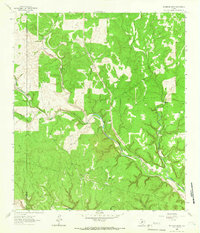
 1968 Monument Mountain1970 Print · USGSThe Texas Hill Country at the end of the sixties reveals a landscape of isolated ranches and rugged highlands along the Mason-Kimble line. Researchers can locate community hubs like Blue Mountain Community Hall or trace the James River and Crocker Landing Strip.
 - 1968 Map of Sheep Run Creek, 1971 Print
 1968 Sheep Run Creek1971 Print · USGSThe Texas Hill Country landscape near the Llano River is captured in the late sixties, showing the convergence of Mason, Menard, and Kimble counties. Trace the paths of Leon Creek and Sheep Run or locate landmarks like Hogg Bluff and James River Road.2 unique versions available
 - 1968 Map of London, 1971 Print
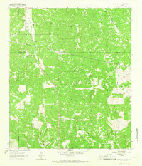
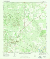 1968 London1971 Print · USGSLondon sits at the heart of this late-sixties Kimble County survey, where the Hill Country terrain meets the local ranching economy. Researchers can locate the London Cem and the prominent Reichenau Gap, or trace the path of the Llano River.
 - 1968 Map of Yates, 1971 Print
 1968 Yates1971 Print · USGSKimble County ranchlands and river valleys appear in high detail during the late sixties. Genealogists and local researchers can trace the roads around Yates to find Ivy Chapel, the Red Creek Cem, and the high ridges of the Blue Mountains.2 unique versions available
End of results
Showing maps 1-8 of 8
Top cities of Kimble County
Frequently asked questions
- What are the different types of historical maps available for Kimble County?
- What is the oldest map of Kimble County?
- Where can I purchase historical maps of Kimble County for my home or office?
- Where can I download high-res historical maps of Kimble County?
- Are there historical topographic maps available for Kimble County?
- Is there historical aerial imagery available for Kimble County?
- Where are historical maps of Kimble County sourced from?