1990s Maps of Liberty County, Texas
Explore 9 historic maps of Liberty County from the 1990s. These maps offer a rare glimpse into what life looked like during the 1990s — showing old roads, neighborhoods, homes, and landmarks that have changed or disappeared over time.
Whether you're researching your family's past, planning a metal detecting trip, or studying how Liberty County's landscape evolved across the 1990s, these high-resolution maps are a powerful tool for exploring the history of this region.
- Focus on a specific era: All maps on this page are from the 1990s, giving you a focused view of this time period.
- See what’s changed: Compare century-old streets, trails, and buildings to today's modern landscape using overlays and satellite layers.
- Research with precision: Use these maps for genealogy, historical research, land use analysis, or educational projects.
- View, download, or print: Maps are fully viewable online in high resolution, and can be downloaded or printed for your own records.
Start exploring Liberty County's history through authentic maps from the 1990s. This is your window into the past.
Liberty County, TX maps
(9)- 1992 Map of Houston
 1992 Houston1992 Print · USGSThe Houston metropolitan area reached its modern sprawl in the early nineties, centered on the Buffalo Bayou and a massive regional rail network. Genealogists and historians can trace the development of satellite cities like Sugar Land and Pasadena, or locate legacy sites like the Humble Oil Field and the NASA Lyndon B Johnson Space Center.
 - 1993 Map of Sheeks, 1994 Print
 1993 Sheeks1994 Print · USGSCoastal Texas in the early nineties reveals a landscape of heavy industry and intricate water management. Genealogists and historians can trace family ties at Harvey Cem or locate the sprawling Esperson Dome Oil Field near Gum Island.
 - 1993 Map of Shiloh, 1994 Print
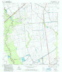
 1993 Shiloh1994 Print · USGSCoastal wetlands and industrial oil fields meet in this early 1990s survey of the Liberty and Chambers county line. Genealogists can trace numerous local burial sites like Lone Star Cem and Sherman Cem near the settlement of Shiloh.
 - 1993 Map of Moss Bluff, 1994 Print
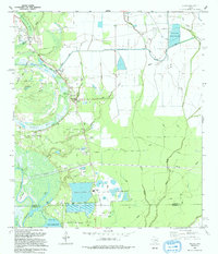
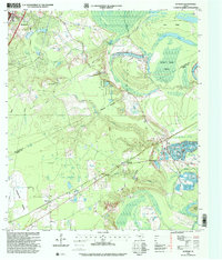
 1993 Moss Bluff1994 Print · USGSThe oxbows of the Trinity River define this Liberty County landscape in the early nineties, where water management and oil production shape the terrain. Genealogists and researchers can locate old burial sites and parish centers like Heir Lawn Cem, Winfree Ch, and the settlement of Moss Bluff.
 - 1994 Map of Winnie NW
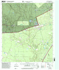
 1994 Winnie NW1994 Print · USGSIn the early nineties, this portion of Jefferson and Liberty Counties shows a landscape defined by coastal bayous and extensive water engineering. Researchers can trace the infrastructure of the Winnie North Base Oil Field and find family-named points like Bauer Ranch and Vogel.
 - 1994 Map of Whites Bayou
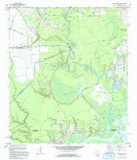
 1994 Whites Bayou1994 Print · USGSThe rural landscape of Liberty County is captured here in the early nineties, showing the balance between coastal agriculture and water management. Researchers can trace the path of Whites Bayou and locate the settlement of Devers amidst a complex network of irrigation canals.
 - 1997 Map of Cleveland, 2000 Print
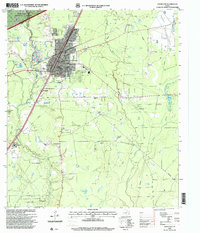 1997 Cleveland2000 Print · USGSIn the late 1990s, Cleveland and its surrounding oil fields were a nexus of industry and community at the edge of the Piney Woods. Genealogists and researchers can trace family roots through several landmarks including Pin Oak Cemetery, New Salem Church, and the outlying settlement of Fostoria.
 - 1997 Map of Fostoria, 2000 Print
 1997 Fostoria2000 Print · USGSThe Montgomery and San Jacinto county lines converged in the late 1990s within the timberlands of the Sam Houston National Forest. Researchers can trace rural family sites and local landmarks like Security Cemetery, Morgan Cemetery, and the settlement of Fostoria.
 - 1997 Map of Rayburn, 2000 Print
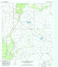
 1997 Rayburn2000 Print · USGSSettlement and industry meet the river bottoms of Liberty and San Jacinto counties in the late nineties. Genealogists and historians can locate Stringtown Cemetery, trace the drainage of Coley Creek, and explore old community sites like Dolen and Hightower.
End of results
Showing maps 1-9 of 9
Top cities of Liberty County
- Liberty historical maps
- Cleveland historical maps
- Dayton historical maps
- Daisetta historical maps
- Ames historical maps
- Plum Grove historical maps
See more
Frequently asked questions
- What are the different types of historical maps available for Liberty County?
- What is the oldest map of Liberty County?
- Where can I purchase historical maps of Liberty County for my home or office?
- Where can I download high-res historical maps of Liberty County?
- Are there historical topographic maps available for Liberty County?
- Is there historical aerial imagery available for Liberty County?
- Where are historical maps of Liberty County sourced from?