1980s Maps of Randall County, Texas
Explore 17 historic maps of Randall County from the 1980s. These maps offer a rare glimpse into what life looked like during the 1980s — showing old roads, neighborhoods, homes, and landmarks that have changed or disappeared over time.
Whether you're researching your family's past, planning a metal detecting trip, or studying how Randall County's landscape evolved across the 1980s, these high-resolution maps are a powerful tool for exploring the history of this region.
- Focus on a specific era: All maps on this page are from the 1980s, giving you a focused view of this time period.
- See what’s changed: Compare century-old streets, trails, and buildings to today's modern landscape using overlays and satellite layers.
- Research with precision: Use these maps for genealogy, historical research, land use analysis, or educational projects.
- View, download, or print: Maps are fully viewable online in high resolution, and can be downloaded or printed for your own records.
Start exploring Randall County's history through authentic maps from the 1980s. This is your window into the past.
Randall County, TX maps
(17)- 1984 Map of Canyon
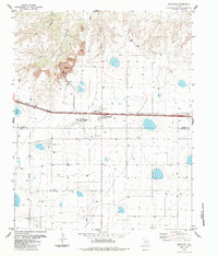
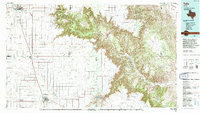
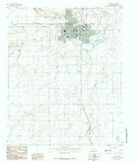 1984 Canyon1984 Print · USGSCanyon and the High Plains come into sharp focus in the mid-1980s as the university campus expands alongside the creeks of the Panhandle. Genealogists and researchers can trace landmarks from the West Texas State University grounds to the southern settlement of Cleta and the waters of Mc Spadden Lake.
 - 1984 Map of Ogg
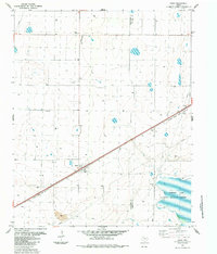
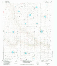
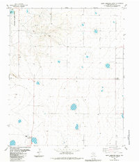
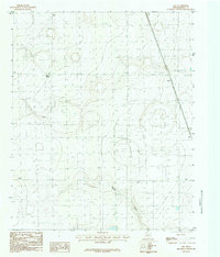 1984 Ogg1984 Print · USGSRandall County, Texas, is captured in the mid-1980s as a landscape of isolated ranching outposts and wide agricultural expanses. Local historians and land researchers can trace the early infrastructure of the Panhandle through sites like Ogg, Black Camp, and Happy Draw.
 - 1984 Map of Wesley Point
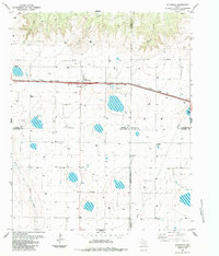
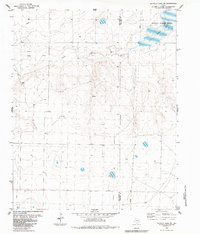
 1984 Wesley Point1984 Print · USGSThe High Plains of the Texas Panhandle meet the sharp breaks of the Palo Duro system in the early 1980s. Researchers can trace the drainage of South Cita Canyon and locate landmarks like Wesley Point and Happy Draw among the cattle country wells.
 - 1984 Map of Bivins Lake
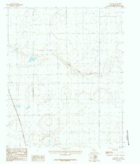
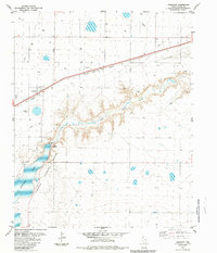
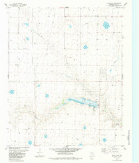 1984 Bivins Lake1984 Print · USGSRandall County ranching and water management are frozen in time in this early eighties survey of the Texas Panhandle. Researchers can trace the path of Palo Duro Creek into Bivins Lake or locate old infrastructure like the Feedlot and Substa.
 - 1984 Map of Dawn
 1984 Dawn1984 Print · USGSThe High Plains of the Texas Panhandle are captured here in the mid-eighties, centered on the railroad settlement of Dawn. Genealogists and researchers can trace the path of the Atchison Topeka and Santa Fe railroad or locate the Buffalo Lake shoreline within its National Wildlife Refuge.
 - 1984 Map of Nance Ranch
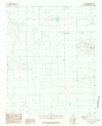 1984 Nance Ranch1984 Print · USGSRandall County, Texas, was characterized by its academic ranching and water infrastructure during the early eighties. Genealogists and researchers can locate the Cem near Nance Ranch or trace the paths of Timber Creek and Corral Draw.
 - 1984 Map of Wildorado
 1984 Wildorado1984 Print · USGSWildorado and the surrounding High Plains are captured here during the early eighties, showcasing the intersection of four Texas counties. Researchers can trace land use through the Feedlot and Elevator, or locate landmarks like Highland School and Ida Lake.
 - 1984 Map of Canyon SE
 1984 Canyon SE1984 Print · USGSThe high plains of Randall County come into focus during the early eighties, showing the land as it was managed for energy and water. Trace the path of South Cita Creek or locate the infrastructure surrounding the town of Happy and the Pipeline routes.2 unique versions available
 - 1984 Map of Bushland
 1984 Bushland1984 Print · USGSThe Texas Panhandle plains south of the Canadian River appear here in the early eighties as a hub of agriculture and industry. Researchers can trace the Old Railroad Grade through Bushland or locate the Cement Plant and nearby Quarry.
 - 1984 Map of Wildorado SW
 1984 Wildorado SW1984 Print · USGSDeaf Smith County in the mid-1980s reveals a functional agricultural landscape defined by the Texas Panhandle's ranching and utility networks. Genealogists and local historians can trace the Palo Duro Wildorado Cemetery, a rural Elevator, and the path of North Palo Duro Creek.
 - 1984 Map of Umbarger
 1984 Umbarger1984 Print · USGSThe High Plains of the Texas Panhandle are captured here in the mid-1980s, centered on the community of Umbarger. Genealogists and researchers can trace local landmarks like St Marys Cem or explore the hydrologic features of the Buffalo Lake National Wildlife Refuge.
 - 1984 Map of Buffalo Lake SW
 1984 Buffalo Lake SW1984 Print · USGSThe Texas Panhandle in the early eighties shows a landscape of managed water and wildlife conservation. Genealogists and historians can trace the Deaf Smith and Randall county line across Buffalo Lake and the National Wildlife Refuge.
 - 1984 Map of Happy Hereford Ranch
 1984 Happy Hereford Ranch1984 Print · USGSRandall County ranching and conservation are captured here in the mid-1980s as the regional landscape transitioned into modern agricultural use. Researchers can trace the layout of the Happy Hereford Ranch, the grounds of the Jowell School, and the early boundaries of the Buffalo Lake National Wildlife Refuge.
 - 1985 Map of Tulia
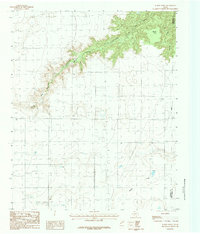
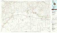
 1985 Tulia1985 Print · USGSThe Texas Panhandle in the mid-1980s displays a stark landscape where industrial agriculture meets the deep breaks of Palo Duro Canyon. Genealogists and researchers can trace rural life near Tulia or find old community centers like Vigo Park, Wayside, and Cleta.2 unique versions available
 - 1985 Map of Hereford
 1985 Hereford1985 Print · USGSThe High Plains of the Texas Panhandle are captured here during the mid-eighties, a period defined by vast agricultural grids and critical rail corridors. Genealogists and local historians can trace the footprint of settlements like Hereford, Dimmitt, and Bovina, alongside the Buffalo Lake National Wildlife Refuge.2 unique versions available
 - 1985 Map of Vega, 1986 Print
 1985 Vega1986 Print · USGSThe Texas Panhandle is captured in the mid-eighties as the cattle and rail economy shaped the landscape from the Canadian River breaks to the southern plains. Researchers can trace the Atchison Topeka and Santa Fe line through Vega and Wildorado or locate landmarks like the Old Railroad Grade and Bivins Lake.2 unique versions available
 - 1986 Map of Amarillo
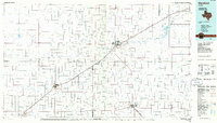
 1986 Amarillo1986 Print · USGSAmarillo and the surrounding Texas Panhandle are captured here in the mid-eighties as a hub of energy, agriculture, and transport. Researchers can trace the sprawling Pantex Plant, the rail-side growth of Panhandle, and the deep cuts of Palo Duro Canyon.2 unique versions available
End of results
Showing maps 1-17 of 17
Top cities of Randall County
- Canyon historical maps
- Lake Tanglewood historical maps
- Timbercreek Canyon historical maps
- Palisades historical maps
Frequently asked questions
- What are the different types of historical maps available for Randall County?
- What is the oldest map of Randall County?
- Where can I purchase historical maps of Randall County for my home or office?
- Where can I download high-res historical maps of Randall County?
- Are there historical topographic maps available for Randall County?
- Is there historical aerial imagery available for Randall County?
- Where are historical maps of Randall County sourced from?