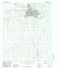
1984 Map of Canyon
USGS Topo · Published 1984About this map
West Texas State University anchors the northeastern portion of this High Plains landscape, where the structured grid of Canyon meets the rugged drainage systems of the Panhandle. This 1984 provisional survey illustrates the intersection of local industry and academia, dominated by the campus and the surrounding residential expansion. The terrain is deeply defined by the winding paths of Palo Duro Creek and Tierra Blanca Creek, which converge near the city center. South of the main settlement, the smaller community of Cleta sits along the roadway, marking a more rural character amidst the complex network of draws including Hackberry Creek and Dry Creek. Key infrastructure like the Pumping Sta and Mc Spadden Lake highlight the critical management of water resources in this arid environment, while a local Cem and various radio towers serve as fixed points for genealogical and historical reference.
Find a feature on this map
11 named features on this map. Tap any name to fly to it.
Don’t see what you’re looking for? This feature index may not catch every label — zoom into the map to look around manually.
Map Details
Editions of this 1984 Canyon Map
This is the sole edition of this map. No revisions or reprints were ever made.
Other maps of this area

1954 · Tucumcari
USGS Topo · 1:250,000

1954 · Amarillo
USGS Topo · 1:250,000

1954 · Plainview
USGS Topo · 1:250,000

1954 · Clovis
USGS Topo · 1:250,000

1958 · Clovis
USGS Topo · 1:250,000

1958 · Amarillo
USGS Topo · 1:250,000

1958 · Tucumcari
USGS Topo · 1:250,000

1958 · Plainview
USGS Topo · 1:250,000

1960 · Canyon
USGS Topo · 1:62,500

1960 · The Palisades
USGS Topo · 1:24,000