1930s Maps of Fort Worth, Texas
Explore 2 historic maps of Fort Worth from the 1930s. These maps offer a rare glimpse into what life looked like during the 1930s — showing old roads, neighborhoods, homes, and landmarks that have changed or disappeared over time.
Whether you're researching your family's past, planning a metal detecting trip, or studying how Fort Worth's landscape evolved across the 1930s, these high-resolution maps are a powerful tool for exploring the history of this region.
- Focus on a specific era: All maps on this page are from the 1930s, giving you a focused view of this time period.
- See what’s changed: Compare century-old streets, trails, and buildings to today's modern landscape using overlays and satellite layers.
- Research with precision: Use these maps for genealogy, historical research, land use analysis, or educational projects.
- View, download, or print: Maps are fully viewable online in high resolution, and can be downloaded or printed for your own records.
Start exploring Fort Worth's history through authentic maps from the 1930s. This is your window into the past.
Fort Worth, TX maps
(2)- 1931 Map of Grapevine
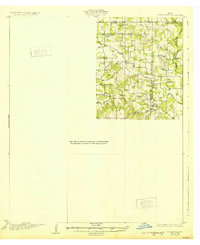
 1931 Grapevine1931 Print · USGSTarrant and Dallas Counties appear in the early thirties as a network of rural settlements and rail-bound transit. Genealogists can locate family landmarks like Randalls Mill, the Bedford Bridge, and early school sites including Shady Grove Sch.2 unique versions available
 - 1932 Map of Springtown
 1932 Springtown1932 Print · USGSThe crossroads of North Texas in the 1920s and 30s reveal a landscape of small farming communities and country parishes. Trace the early footprints of Reno, Briar, and Azle, or locate family sites near New Hope Ch and Onion Hill Sch.
End of results
Showing maps 1-2 of 2
Top cities near Fort Worth
- Arlington historical maps
- Flower Mound historical maps
- North Richland Hills historical maps
- Mansfield historical maps
- Euless historical maps
- Grapevine historical maps
See more
Top neighborhoods of Fort Worth
- Eagle Mountain historical maps
- Tarrant historical maps
- Lytle historical maps
- Melody Hills historical maps
- Primrose historical maps
- Iona historical maps
See more
Frequently asked questions
- What are the different types of historical maps available for Fort Worth?
- What is the oldest map of Fort Worth?
- Where can I purchase historical maps of Fort Worth for my home or office?
- Where can I download high-res historical maps of Fort Worth?
- Are there historical topographic maps available for Fort Worth?
- Is there historical aerial imagery available for Fort Worth?
- Where are historical maps of Fort Worth sourced from?