1990s Maps of Trinity County, Texas
Explore 4 historic maps of Trinity County from the 1990s. These maps offer a rare glimpse into what life looked like during the 1990s — showing old roads, neighborhoods, homes, and landmarks that have changed or disappeared over time.
Whether you're researching your family's past, planning a metal detecting trip, or studying how Trinity County's landscape evolved across the 1990s, these high-resolution maps are a powerful tool for exploring the history of this region.
- Focus on a specific era: All maps on this page are from the 1990s, giving you a focused view of this time period.
- See what’s changed: Compare century-old streets, trails, and buildings to today's modern landscape using overlays and satellite layers.
- Research with precision: Use these maps for genealogy, historical research, land use analysis, or educational projects.
- View, download, or print: Maps are fully viewable online in high resolution, and can be downloaded or printed for your own records.
Start exploring Trinity County's history through authentic maps from the 1990s. This is your window into the past.
Trinity County, TX maps
(4)- 1992 Map of Livingston
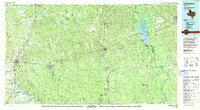 1992 Livingston1992 Print · USGSSoutheast Texas at the start of the nineties reveals a landscape of deep pine forests, oil fields, and historic rural communities. Researchers can locate family landmarks like Holly Grove Cem and Wildwood Sch, or trace the winding Angelina River near B A Steinhagen Lake.
 - 1992 Map of Lufkin
 1992 Lufkin1992 Print · USGSThe Piney Woods of East Texas are captured here in the early nineties, centered on the growing industrial hub of Lufkin. Local researchers can trace the rail networks of the Angelina & Neches River RR and locate rural landmarks like Shady Grove Ch and Manning.
 - 1997 Map of Staley, 2000 Print
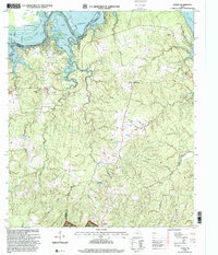 1997 Staley2000 Print · USGSThe Sam Houston National Forest meets the Trinity River in the late nineties, documenting the landscape around Staley (Embryfield). Genealogists can trace family landmarks like Gospel Hill Cemetery and Chapel Church.
 - 1997 Map of Riverside, 2000 Print
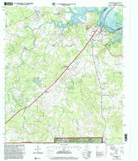 1997 Riverside2000 Print · USGSWalker County during the late nineties reveals a landscape where the Sam Houston National Forest meets the industrial outskirts of Riverside. Genealogists can trace family landmarks like the Dodge Cemetery, Thessaloniki Church, and the specialized State Fish Hatchery.
End of results
Showing maps 1-4 of 4
Top cities of Trinity County
Frequently asked questions
- What are the different types of historical maps available for Trinity County?
- What is the oldest map of Trinity County?
- Where can I purchase historical maps of Trinity County for my home or office?
- Where can I download high-res historical maps of Trinity County?
- Are there historical topographic maps available for Trinity County?
- Is there historical aerial imagery available for Trinity County?
- Where are historical maps of Trinity County sourced from?