1800s (19th Century) Maps of Uvalde County, Texas
Explore 6 historic maps of Uvalde County from the 1800s (19th Century). These maps offer a rare glimpse into what life looked like during the 1800s — showing old roads, neighborhoods, homes, and landmarks that have changed or disappeared over time.
Whether you're researching your family's past, planning a metal detecting trip, or studying how Uvalde County's landscape evolved across the 1800s, these high-resolution maps are a powerful tool for exploring the history of this region.
- Focus on a specific era: All maps on this page are from the 1800s, giving you a focused view of this time period.
- See what’s changed: Compare century-old streets, trails, and buildings to today's modern landscape using overlays and satellite layers.
- Research with precision: Use these maps for genealogy, historical research, land use analysis, or educational projects.
- View, download, or print: Maps are fully viewable online in high resolution, and can be downloaded or printed for your own records.
Start exploring Uvalde County's history through authentic maps from the 1800s. This is your window into the past.
Uvalde County, TX maps
(6)- 1893 Map of Nueces
 1893 Nueces1893 Print · USGSTexas ranching culture and the canyons of the Nueces River are captured here during the 1890s frontier era. Genealogists and local historians can trace early family landholdings like the Ford and Holliday Ranch and remote settlements such as Camp Wood or Barksdale.
 - 1896 Map of Nueces
 1896 Nueces1896 Print · USGSThe upper Nueces River valley in the 1890s is captured here as a network of isolated family ranches and riverfront settlements. Genealogists and historians can trace early landholders at the Ford and Holliday Ranch, Johnson Ranch, and Hillcoat Ranch.4 unique versions available
 - 1896 Map of Brackett
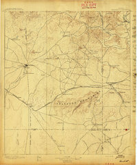
 1896 Brackett1896 Print · USGSSouthwest Texas ranching and military life come into focus in the 1890s, centered on the strategic presence of the frontier army. Genealogists can trace family holdings like Weymiller Ranch or find early communities such as the Seminole Settlement and Spofford.
 - 1897 Map of Brackett
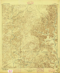
 1897 Brackett1897 Print · USGSThe frontier of Kinney and Uvalde counties is captured here in the late nineteenth century, centered on the military and ranching hub of Brackett. Researchers can trace the Southern Pacific R. R. through Cline or locate the historic Seminole Settlement and Fort Clark.3 unique versions available
 - 1898 Map of Uvalde
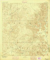
 1898 Uvalde1898 Print · USGSTexas ranching culture and early rail expansion meet in the late 1890s across this detailed landscape. Genealogists and researchers can trace family-named estates like Molesworth Ranch, locate the Sansom P.O., and find industrial relics like the Silver Mine.3 unique versions available
 - 1899 Map of Uvalde, 1931 Print
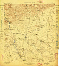
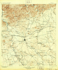 1899 Uvalde1931 Print · USGSThe South Texas ranching frontier comes into focus during the late nineteenth century as railroads began to transform the cattle economy. Researchers can trace family ranch lands such as McDaniels Ranch, locate the Sansom P.O. at Uvalde, and find local landmarks like Myricks Upper Apiary.
End of results
Showing maps 1-6 of 6
Top cities of Uvalde County
- Uvalde historical maps
- Uvalde Estates historical maps
- Sabinal historical maps
- Knippa historical maps
- Utopia historical maps
Frequently asked questions
- What are the different types of historical maps available for Uvalde County?
- What is the oldest map of Uvalde County?
- Where can I purchase historical maps of Uvalde County for my home or office?
- Where can I download high-res historical maps of Uvalde County?
- Are there historical topographic maps available for Uvalde County?
- Is there historical aerial imagery available for Uvalde County?
- Where are historical maps of Uvalde County sourced from?