1940s Maps of Zavala County, Texas
Explore 4 historic maps of Zavala County from the 1940s. These maps offer a rare glimpse into what life looked like during the 1940s — showing old roads, neighborhoods, homes, and landmarks that have changed or disappeared over time.
Whether you're researching your family's past, planning a metal detecting trip, or studying how Zavala County's landscape evolved across the 1940s, these high-resolution maps are a powerful tool for exploring the history of this region.
- Focus on a specific era: All maps on this page are from the 1940s, giving you a focused view of this time period.
- See what’s changed: Compare century-old streets, trails, and buildings to today's modern landscape using overlays and satellite layers.
- Research with precision: Use these maps for genealogy, historical research, land use analysis, or educational projects.
- View, download, or print: Maps are fully viewable online in high resolution, and can be downloaded or printed for your own records.
Start exploring Zavala County's history through authentic maps from the 1940s. This is your window into the past.
Zavala County, TX maps
(4)- 1940 Map of Cometa, 1958 Print
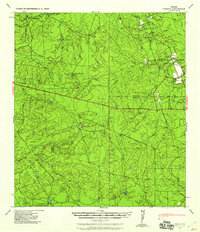 1940 Cometa1958 Print · USGSSouthwest Texas ranching country in the early nineteen-forties shows a landscape of large family holdings and seasonal creek beds. Genealogists can trace specific homesteads such as the Sullivan Ranch, F C Anglin Ranch, and the small settlement at Cometa.2 unique versions available
 - 1940 Map of Chacon Creek, 1959 Print
 1940 Chacon Creek1959 Print · USGSRanching operations and early energy pipelines define the Maverick and Zavala County line at the start of the 1940s. Genealogists and historians can locate family-named homesteads such as Plumly Ranch and Van Cleve Ranch or trace water sources like Chilipin Lake.
 - 1942 Map of Divot
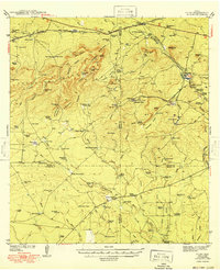
 1942 Divot1942 Print · USGSThe cattle country of South Texas comes into focus in the early 1940s, where the Frio and Leona rivers meet amidst a network of large family ranches. Genealogists and historians can locate legacy holdings like Roberts Ranch and Rogers Ranch, or trace water sources like Berry Crossing and the Crawford Windmills.
 - 1949 Map of Cline
 1949 Cline1949 Print · USGSSouthwest Texas ranching and asphalt mining are captured here in the late 1930s and 40s. Genealogists and historians can locate family landmarks like Finley Ranch and trace the specialized Asphalt Belt Line railroad serving Blewett.2 unique versions available
End of results
Showing maps 1-4 of 4
Top cities of Zavala County
Frequently asked questions
- What are the different types of historical maps available for Zavala County?
- What is the oldest map of Zavala County?
- Where can I purchase historical maps of Zavala County for my home or office?
- Where can I download high-res historical maps of Zavala County?
- Are there historical topographic maps available for Zavala County?
- Is there historical aerial imagery available for Zavala County?
- Where are historical maps of Zavala County sourced from?