1930s Maps of Zavala County, Texas
Explore 3 historic maps of Zavala County from the 1930s. These maps offer a rare glimpse into what life looked like during the 1930s — showing old roads, neighborhoods, homes, and landmarks that have changed or disappeared over time.
Whether you're researching your family's past, planning a metal detecting trip, or studying how Zavala County's landscape evolved across the 1930s, these high-resolution maps are a powerful tool for exploring the history of this region.
- Focus on a specific era: All maps on this page are from the 1930s, giving you a focused view of this time period.
- See what’s changed: Compare century-old streets, trails, and buildings to today's modern landscape using overlays and satellite layers.
- Research with precision: Use these maps for genealogy, historical research, land use analysis, or educational projects.
- View, download, or print: Maps are fully viewable online in high resolution, and can be downloaded or printed for your own records.
Start exploring Zavala County's history through authentic maps from the 1930s. This is your window into the past.
Zavala County, TX maps
(3)- 1939 Map of Carrizo Springs, 1958 Print
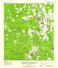 1939 Carrizo Springs1958 Print · USGSSouth Texas ranching and agriculture reach a peak in the late 1930s as irrigation and rail lines transformed the brush country. Genealogists can trace family holdings from Rancho Grande to Giesler Farm, or locate landmarks like the Hermann Sons Lodge.2 unique versions available
 - 1939 Map of Big Wells, 1958 Print
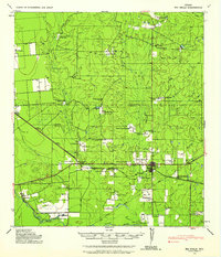 1939 Big Wells1958 Print · USGSDimmit and Zavala counties are captured here just before World War II, showing a landscape defined by the railroad and large cattle ranches. Researchers can trace historic family holdings like the Snyder Ranch and transport hubs including Brundage and J. N. Siding.
 - 1939 Map of La Pryor, 1958 Print
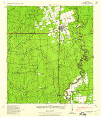 1939 La Pryor1958 Print · USGSZavala County ranching and rail infrastructure are on full display in this late 1930s survey. Researchers can trace family ranchsteads like Chaparrosa Ranch or the rail junction at La Pryor and Zacate Siding.2 unique versions available
End of results
Showing maps 1-3 of 3
Top cities of Zavala County
Frequently asked questions
- What are the different types of historical maps available for Zavala County?
- What is the oldest map of Zavala County?
- Where can I purchase historical maps of Zavala County for my home or office?
- Where can I download high-res historical maps of Zavala County?
- Are there historical topographic maps available for Zavala County?
- Is there historical aerial imagery available for Zavala County?
- Where are historical maps of Zavala County sourced from?