1900s (20th Century) Maps of Zavala County, Texas
Explore 50 historic maps of Zavala County from the 1900s (20th Century). These maps offer a rare glimpse into what life looked like during the 1900s — showing old roads, neighborhoods, homes, and landmarks that have changed or disappeared over time.
Whether you're researching your family's past, planning a metal detecting trip, or studying how Zavala County's landscape evolved across the 1900s, these high-resolution maps are a powerful tool for exploring the history of this region.
- Focus on a specific era: All maps on this page are from the 1900s, giving you a focused view of this time period.
- See what’s changed: Compare century-old streets, trails, and buildings to today's modern landscape using overlays and satellite layers.
- Research with precision: Use these maps for genealogy, historical research, land use analysis, or educational projects.
- View, download, or print: Maps are fully viewable online in high resolution, and can be downloaded or printed for your own records.
Start exploring Zavala County's history through authentic maps from the 1900s. This is your window into the past.
Zavala County, TX maps
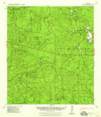
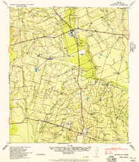
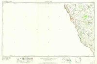
(50)- 1928 Map of Frio Town, 1956 Print
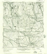 1928 Frio Town1956 Print · USGSThe ranchlands of South Texas are documented here in the late 1920s, showing a landscape shaped by water rights and family holdings. Genealogists and local historians can trace the bounds of the Schuddemagen Ranch and Woodward Ranch or locate the old Post Office at Frio Town.
 - 1939 Map of Carrizo Springs, 1958 Print
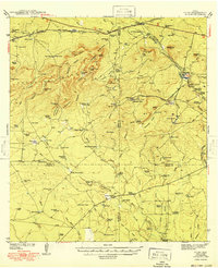
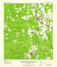 1939 Carrizo Springs1958 Print · USGSSouth Texas ranching and agriculture reach a peak in the late 1930s as irrigation and rail lines transformed the brush country. Genealogists can trace family holdings from Rancho Grande to Giesler Farm, or locate landmarks like the Hermann Sons Lodge.2 unique versions available
 - 1939 Map of Big Wells, 1958 Print
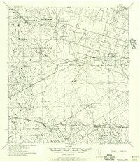
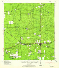 1939 Big Wells1958 Print · USGSDimmit and Zavala counties are captured here just before World War II, showing a landscape defined by the railroad and large cattle ranches. Researchers can trace historic family holdings like the Snyder Ranch and transport hubs including Brundage and J. N. Siding.
 - 1939 Map of La Pryor, 1958 Print
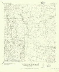
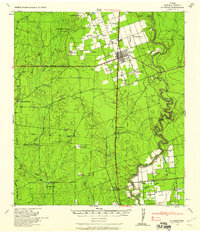 1939 La Pryor1958 Print · USGSZavala County ranching and rail infrastructure are on full display in this late 1930s survey. Researchers can trace family ranchsteads like Chaparrosa Ranch or the rail junction at La Pryor and Zacate Siding.2 unique versions available
 - 1940 Map of Cometa, 1958 Print
 1940 Cometa1958 Print · USGSSouthwest Texas ranching country in the early nineteen-forties shows a landscape of large family holdings and seasonal creek beds. Genealogists can trace specific homesteads such as the Sullivan Ranch, F C Anglin Ranch, and the small settlement at Cometa.2 unique versions available
 - 1940 Map of Chacon Creek, 1959 Print
 1940 Chacon Creek1959 Print · USGSRanching operations and early energy pipelines define the Maverick and Zavala County line at the start of the 1940s. Genealogists and historians can locate family-named homesteads such as Plumly Ranch and Van Cleve Ranch or trace water sources like Chilipin Lake.
 - 1942 Map of Divot
 1942 Divot1942 Print · USGSThe cattle country of South Texas comes into focus in the early 1940s, where the Frio and Leona rivers meet amidst a network of large family ranches. Genealogists and historians can locate legacy holdings like Roberts Ranch and Rogers Ranch, or trace water sources like Berry Crossing and the Crawford Windmills.
 - 1949 Map of Cline
 1949 Cline1949 Print · USGSSouthwest Texas ranching and asphalt mining are captured here in the late 1930s and 40s. Genealogists and historians can locate family landmarks like Finley Ranch and trace the specialized Asphalt Belt Line railroad serving Blewett.2 unique versions available
 - 1953 Map of Crystal City
 1953 Crystal City1953 Print · USGSSouth Texas in the early fifties was a landscape of expanding oil fields and vital rail connections. Genealogists and researchers can trace family lands along the Nueces River or locate heritage sites in Asherton, Big Wells, and Batesville.
 - 1954 Map of San Antonio, 1964 Print
 1954 San Antonio1964 Print · USGSSan Antonio and the Texas Hill Country are captured here in the mid-fifties, showing a landscape defined by massive military air bases and the rising Canyon Reservoir. Trace family ties through historic rail towns like D'Hanis and Castroville or explore the Cold War footprint of Lackland AFB and Randolph AFB.3 unique versions available
 - 1955 Map of Crystal City, 1976 Print
 1955 Crystal City1976 Print · USGSSouth Texas ranching and oil country come into focus in the mid-fifties as the rail lines and rivers connect growing hubs. Researchers can trace the development of energy fields like Washburn Oil Field or locate historic settlements from Asherton to Three Rivers.
 - 1956 Map of Woodward
 1956 Woodward1956 Print · USGSMid-century ranching and rail life dominate the South Texas borderlands where four counties meet. Genealogists and historians can trace family holdings like Vesper Ranch or El Cid Ranch and locate the rail stop at Woodward.
 - 1956 Map of Divot
 1956 Divot1956 Print · USGSRanching life on the Frio County line during the mid-twentieth century centers on scattered homesteads and vital river crossings. Researchers can locate family landmarks such as Higdon Ranch and Rogers Ranch or trace early water infrastructure at Division Tank.
 - 1957 Map of San Antonio
 1957 San Antonio1957 Print · USGSSan Antonio and the Texas Hill Country are shown here during the mid-fifties, capturing the region's expanding post-war military and transportation footprint. Genealogists and local historians can trace the early residential boundaries of Alamo Heights or locate rural landmarks like St Hedwig and Medina Lake.
 - 1957 Map of Batesville
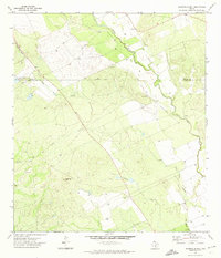
 1957 Batesville1957 Print · USGSThe Zavala County brush country around the Leona River is shown here as a patchwork of family-owned ranching estates during the mid-twentieth century. Researchers can locate specific family holdings like the Mundine Ranch or Carmichael Ranch and trace local landmarks such as Loma Vista School.
 - 1958 Map of Eagle Pass, 1969 Print
 1958 Eagle Pass1969 Print · USGSThe borderlands of South Texas come alive in this mid-century look at the ranching and rail corridor along the Rio Grande. Genealogists and historians can trace legacy holdings like San Pedro Ranch, find the Maverick Canal network, and locate rail sidings at Darling.2 unique versions available
 - 1958 Map of Del Rio, 1970 Print
 1958 Del Rio1970 Print · USGSThe Texas-Mexico borderlands come alive in the late fifties, showing the confluence of the Rio Grande and the emerging Amistad Reservoir. Trace the lineage of the Southern Pacific rail line through stops at Pumpville, Shumla, and the mining vicinity of Blewett.2 unique versions available
 - 1960 Map of Pulliam Ranch, 1962 Print
 1960 Pulliam Ranch1962 Print · USGSRanching operations in South Texas define this landscape at the dawn of the sixties, where family estates dominate the riverbanks. Genealogists and historians can trace the specific boundaries of the Pulliam Ranch, Palmer Ranch, and the rail siding at A B Junction.
 - 1960 Map of Sand Mountain, 1962 Print
 1960 Sand Mountain1962 Print · USGSZavala and Uvalde Counties in the early sixties reveal a landscape of remote ranching outposts and vital water infrastructure along the Nueces River. Genealogists and historians can trace family holdings like Anthon Ranch or Lyles Ranch and locate the historic Smyth Station along the Missouri Pacific tracks.
 - 1961 Map of Crystal City
 1961 Crystal City1961 Print · USGSSouth Texas in the early sixties reveals a landscape of massive cattle ranches and emerging oil fields. Genealogists and historians can trace the Missouri Pacific rail lines through Crystal City, or locate water features like Espantosa Lake and Boynton Reservoir.
 - 1964 Map of Del Rio
 1964 Del Rio1964 Print · USGSAlong the Mexican border during the mid-sixties, this area centered on the confluence of the Rio Grande and Devils River. Researchers can trace the Southern Pacific line through isolated stops like Pumpville or locate military and industrial sites such as Laughlin Air Force Base and the mines at Blewett.
 - 1965 Map of Eagle Pass
 1965 Eagle Pass1965 Print · USGSThe Texas-Mexico borderlands come into focus in the mid-1960s, centered on the river life and ranching culture of Maverick County. Researchers can trace the legacy of major landholdings like Burr Ranch and Loma Linda Ranch alongside landmarks like the Hydroelectric Plant.
 - 1968 Map of Crystal City
 1968 Crystal City1968 Print · USGSSouth Texas in the late sixties reveals a landscape shaped by ranching roots and the vital waters of the Nueces River. Researchers can trace the rail-driven growth of Crystal City or locate landmarks like Pilot Knob and Espantosa Lake.
 - 1971 Map of Batesville Hill, 1974 Print
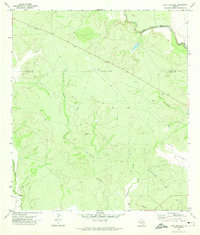
 1971 Batesville Hill1974 Print · USGSThe South Texas brush country along the Uvalde and Zavala county line is documented here in the early seventies. Researchers can locate a solitary Grave near the Leona River or trace the drainage of Camp Lake Slough and Gallina Creek.
 - 1971 Map of Lone Tree Hill, 1974 Print
 1971 Lone Tree Hill1974 Print · USGSZavala and Uvalde counties are shown here in the early seventies, a landscape defined by the winding paths of the Frio River and Leona River. Researchers can trace the rural development of the era through landmarks like Lone Tree Hill, isolated Well sites, and a local Landing Strip.
Showing maps 1-25 of 50
Top cities of Zavala County
Frequently asked questions
- What are the different types of historical maps available for Zavala County?
- What is the oldest map of Zavala County?
- Where can I purchase historical maps of Zavala County for my home or office?
- Where can I download high-res historical maps of Zavala County?
- Are there historical topographic maps available for Zavala County?
- Is there historical aerial imagery available for Zavala County?
- Where are historical maps of Zavala County sourced from?