1960s Maps of Zavala County, Texas
Explore 6 historic maps of Zavala County from the 1960s. These maps offer a rare glimpse into what life looked like during the 1960s — showing old roads, neighborhoods, homes, and landmarks that have changed or disappeared over time.
Whether you're researching your family's past, planning a metal detecting trip, or studying how Zavala County's landscape evolved across the 1960s, these high-resolution maps are a powerful tool for exploring the history of this region.
- Focus on a specific era: All maps on this page are from the 1960s, giving you a focused view of this time period.
- See what’s changed: Compare century-old streets, trails, and buildings to today's modern landscape using overlays and satellite layers.
- Research with precision: Use these maps for genealogy, historical research, land use analysis, or educational projects.
- View, download, or print: Maps are fully viewable online in high resolution, and can be downloaded or printed for your own records.
Start exploring Zavala County's history through authentic maps from the 1960s. This is your window into the past.
Zavala County, TX maps
(6)- 1960 Map of Pulliam Ranch, 1962 Print
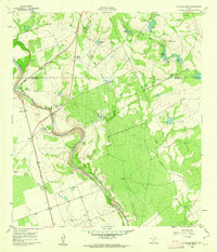 1960 Pulliam Ranch1962 Print · USGSRanching operations in South Texas define this landscape at the dawn of the sixties, where family estates dominate the riverbanks. Genealogists and historians can trace the specific boundaries of the Pulliam Ranch, Palmer Ranch, and the rail siding at A B Junction.
 - 1960 Map of Sand Mountain, 1962 Print
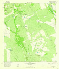 1960 Sand Mountain1962 Print · USGSZavala and Uvalde Counties in the early sixties reveal a landscape of remote ranching outposts and vital water infrastructure along the Nueces River. Genealogists and historians can trace family holdings like Anthon Ranch or Lyles Ranch and locate the historic Smyth Station along the Missouri Pacific tracks.
 - 1961 Map of Crystal City
 1961 Crystal City1961 Print · USGSSouth Texas in the early sixties reveals a landscape of massive cattle ranches and emerging oil fields. Genealogists and historians can trace the Missouri Pacific rail lines through Crystal City, or locate water features like Espantosa Lake and Boynton Reservoir.
 - 1964 Map of Del Rio
 1964 Del Rio1964 Print · USGSAlong the Mexican border during the mid-sixties, this area centered on the confluence of the Rio Grande and Devils River. Researchers can trace the Southern Pacific line through isolated stops like Pumpville or locate military and industrial sites such as Laughlin Air Force Base and the mines at Blewett.
 - 1965 Map of Eagle Pass
 1965 Eagle Pass1965 Print · USGSThe Texas-Mexico borderlands come into focus in the mid-1960s, centered on the river life and ranching culture of Maverick County. Researchers can trace the legacy of major landholdings like Burr Ranch and Loma Linda Ranch alongside landmarks like the Hydroelectric Plant.
 - 1968 Map of Crystal City
 1968 Crystal City1968 Print · USGSSouth Texas in the late sixties reveals a landscape shaped by ranching roots and the vital waters of the Nueces River. Researchers can trace the rail-driven growth of Crystal City or locate landmarks like Pilot Knob and Espantosa Lake.
End of results
Showing maps 1-6 of 6
Top cities of Zavala County
Frequently asked questions
- What are the different types of historical maps available for Zavala County?
- What is the oldest map of Zavala County?
- Where can I purchase historical maps of Zavala County for my home or office?
- Where can I download high-res historical maps of Zavala County?
- Are there historical topographic maps available for Zavala County?
- Is there historical aerial imagery available for Zavala County?
- Where are historical maps of Zavala County sourced from?