1980s Maps of Zavala County, Texas
Explore 4 historic maps of Zavala County from the 1980s. These maps offer a rare glimpse into what life looked like during the 1980s — showing old roads, neighborhoods, homes, and landmarks that have changed or disappeared over time.
Whether you're researching your family's past, planning a metal detecting trip, or studying how Zavala County's landscape evolved across the 1980s, these high-resolution maps are a powerful tool for exploring the history of this region.
- Focus on a specific era: All maps on this page are from the 1980s, giving you a focused view of this time period.
- See what’s changed: Compare century-old streets, trails, and buildings to today's modern landscape using overlays and satellite layers.
- Research with precision: Use these maps for genealogy, historical research, land use analysis, or educational projects.
- View, download, or print: Maps are fully viewable online in high resolution, and can be downloaded or printed for your own records.
Start exploring Zavala County's history through authentic maps from the 1980s. This is your window into the past.
Zavala County, TX maps
(4)- 1985 Map of Eagle Pass
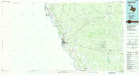 1985 Eagle Pass1985 Print · USGSThe Texas-Mexico borderlands come into focus in the mid-1980s as Eagle Pass grows along the Rio Grande. Genealogists and historians can trace the rail corridor of the Southern Pacific and locate rural communities like Normandy and El Indio.
 - 1985 Map of Uvalde
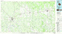 1985 Uvalde1985 Print · USGSUvalde and the surrounding river valleys are captured here in the mid-eighties as a busy crossroads of rail and ranching. Genealogists can locate family sites near Frio Town or trace the Southern Pacific line through Knippa and Sabinal.
 - 1985 Map of Crystal City
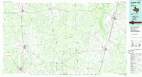 1985 Crystal City1985 Print · USGSThe Texas Winter Garden region comes into focus during the mid-1980s, detailing a landscape of irrigation, energy, and rail. Genealogists and researchers can trace lineage through rural centers like Big Wells, Winter Haven, and Loma Vista or locate early industrial sites such as the Big Wells Oil Field.2 unique versions available
 - 1986 Map of Del Rio
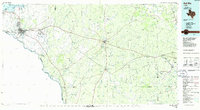 1986 Del Rio1986 Print · USGSThe West Texas borderlands come alive in the mid-eighties as Del Rio expands and Laughlin AFB anchors the local economy. Researchers can trace the rail corridors through Spofford and Cline or locate family sites near Alamo Village.2 unique versions available
End of results
Showing maps 1-4 of 4
Top cities of Zavala County
Frequently asked questions
- What are the different types of historical maps available for Zavala County?
- What is the oldest map of Zavala County?
- Where can I purchase historical maps of Zavala County for my home or office?
- Where can I download high-res historical maps of Zavala County?
- Are there historical topographic maps available for Zavala County?
- Is there historical aerial imagery available for Zavala County?
- Where are historical maps of Zavala County sourced from?