1990s Maps of Grand County, Utah
Explore 35 historic maps of Grand County from the 1990s. These maps offer a rare glimpse into what life looked like during the 1990s — showing old roads, neighborhoods, homes, and landmarks that have changed or disappeared over time.
Whether you're researching your family's past, planning a metal detecting trip, or studying how Grand County's landscape evolved across the 1990s, these high-resolution maps are a powerful tool for exploring the history of this region.
- Focus on a specific era: All maps on this page are from the 1990s, giving you a focused view of this time period.
- See what’s changed: Compare century-old streets, trails, and buildings to today's modern landscape using overlays and satellite layers.
- Research with precision: Use these maps for genealogy, historical research, land use analysis, or educational projects.
- View, download, or print: Maps are fully viewable online in high resolution, and can be downloaded or printed for your own records.
Start exploring Grand County's history through authentic maps from the 1990s. This is your window into the past.
Grand County, UT maps
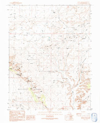
(35)- 1991 Map of Thompson Springs
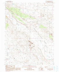
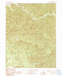
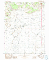
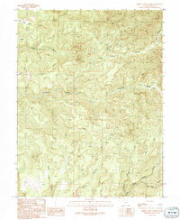
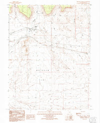 1991 Thompson Springs1991 Print · USGSThompson Springs in the early nineties is a study in desert transit and resource infrastructure. Researchers can trace the town's footprint from the Cem and Trailer Park out to the Old Railroad Grade and the vast Whipsaw Flat.
 - 1991 Map of Butler Canyon
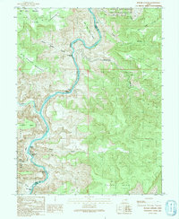 1991 Butler Canyon1991 Print · USGSThe Green River canyons in Grand and Emery counties are shown here as they appeared in the early 1990s. Boaters and historians can trace the sequence of white water and landmarks, from Nefertiti Rapids and Nefertiti Rock to Butler Rapids.
 - 1991 Map of Calf Canyon
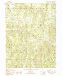
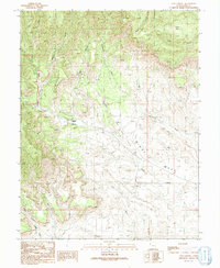 1991 Calf Canyon1991 Print · USGSGrand County, Utah, was a hub of energy exploration in the early 1990s as the high desert landscape was etched with extraction sites. You can trace the development of the Cisco Dome Oil and Gas Field and find the remote Cunningham Ranch along Nash Wash.
 - 1991 Map of Dee Pass
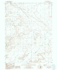 1991 Dee Pass1991 Print · USGSGrand County, Utah, was a landscape of remote desert drainages and mineral prospecting during the early nineties. You can trace the rugged topography of Tenmile Canyon and locate isolated water sources and mining sites like Levi Well and various Prospects.
 - 1991 Map of Klondike Bluffs
 1991 Klondike Bluffs1991 Print · USGSGrand County, Utah, is shown in the early 1990s as a landscape of dramatic formations and early aviation infrastructure. Researchers can trace the boundaries of Arches National Park and locate landmarks like Tower Arch, Canyonlands Field, and Dark Angel.
 - 1991 Map of Walker Point
 1991 Walker Point1991 Print · USGSGrand County's high canyon country is documented here during the early nineties within the Uintah and Ouray Indian Reservation. Researchers can trace old routes like the Wagon Road and locate remote outposts such as the Hill Creek Ranger Sta and Hill Creek Youth Camp.
 - 1991 Map of Floy Canyon North
 1991 Floy Canyon North1991 Print · USGSGrand County, Utah, was still a remote landscape of high ridges and reservation land in the early 1990s. Researchers can trace the path of the historic Wagon Road and locate critical water sources like Nutters Hole and Showerbath Spring among the deep canyons.
 - 1991 Map of Cisco SW
 1991 Cisco SW1991 Print · USGSGrand County's high desert reveals its mining and ranching history in the early nineties, from the fringes of the national park to the uranium-bearing plateaus. Trace the locations of the Cactus Rat Mine and remote water sources like Lipiquitno Water and Yellow Cat Reservoir.
 - 1991 Map of Tenmile Canyon South
 1991 Tenmile Canyon South1991 Print · USGSGrand County, Utah, was a landscape of remote canyonlands and high ridges in the early nineties, shaped by ancient drainage systems. Researchers can locate critical water sources like Kelly Spring and trace primitive routes past landmarks such as Tenmile Knoll and Moon Ridge.
 - 1991 Map of Blue Castle Butte
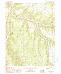
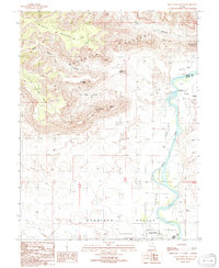 1991 Blue Castle Butte1991 Print · USGSThe Green River corridor at the turn of the 1990s reveals the intersection of irrigation infrastructure and desert geography. Local researchers can trace the historic Elgin Cemetery or examine water systems at Tusher Dam and the headgate.
 - 1991 Map of Tusher Canyon
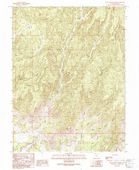
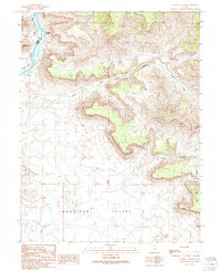 1991 Tusher Canyon1991 Print · USGSThe high desert canyons and the Green River corridor are mapped here as they appeared in the early 1990s. Local researchers can trace old ranching infrastructure like Water Tanks or locate landmarks such as Gunnison Butte and Swaseys Rapids.
 - 1991 Map of Cisco
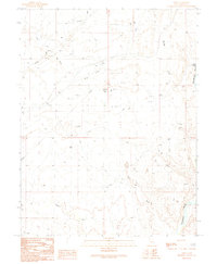 1991 Cisco1991 Print · USGSCisco was a critical rail and energy hub in the Utah desert during the late twentieth century. Researchers can trace the industrial footprint of the Gas and Oil Field, the path of the Old Railroad Grade, and remote outposts like Cisco Landing.
 - 1991 Map of Lion Canyon
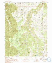
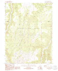
 1991 Lion Canyon1991 Print · USGSGrand County, Utah, is shown in the early 1990s as a landscape of deep canyons and tribal lands. Researchers can trace the drainage of Florence Creek and identify landmarks like Dripping Springs, the Natural Arch, and the high ridges of the McPherson Range.
 - 1991 Map of Sego Canyon
 1991 Sego Canyon1991 Print · USGSGrand County during the early nineties reveals a landscape of deep canyons and former mining operations near the Book Cliffs. Researchers can trace the remnants of Sego (Site), locating its Cem, Adit, and the winding paths of Sego Canyon.
 - 1991 Map of Tenmile Canyon North
 1991 Tenmile Canyon North1991 Print · USGSThe high plateau of eastern Utah in the early nineties reveals a complex network of canyons and ridges along the Uintah and Grand county line. Researchers can trace land use through features like an Oil well and follow the rugged path of Tenmile Canyon or Kelly Meadow Creek.
 - 1991 Map of Floy Canyon South
 1991 Floy Canyon South1991 Print · USGSGrand County, Utah, is shown in the early nineties as a landscape of deep drainages and high mesas. Researchers can trace the ranching and mining footprints of the area, locating Crescent Mine, Trough Spring, and the prominent Crescent Butte.
 - 1991 Map of Mollie Hogans
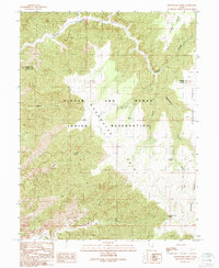
 1991 Mollie Hogans1991 Print · USGSGrand County, Utah, was a land of both preservation and extraction in the early 1990s, where park boundaries met active mining claims. Researchers can trace the legacy of uranium mining at Parco Mines or locate the famous stone spans of Devils Garden and the Fiery Furnace.2 unique versions available
 - 1991 Map of Tepee Canyon
 1991 Tepee Canyon1991 Print · USGSThe high plateaus and deep drainages of Grand County, Utah, are captured in the early nineties before modern expansion. Map collectors and researchers can trace the rugged topography of Diamond Ridge and locate specific sites like the Drill Hole and Cottonwood Point.
 - 1991 Map of Hatch Mesa
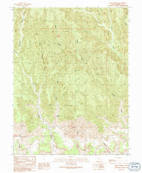
 1991 Hatch Mesa1991 Print · USGSGrand County, Utah, was still a landscape of remote mesas and industrial traces in the early nineties. Genealogists and historians can trace the Old Railroad Grade and locate isolated outposts like Solitude, Browns, and the settlement at Floy.
 - 1991 Map of Supply Canyon
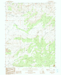
 1991 Supply Canyon1991 Print · USGSThe high ridges of eastern Utah are captured here in the early 1990s, showcasing the remote lands of the Uintah and Ouray Indian Reservation. Researchers can trace the path of the old Wagon and Road or locate natural features like Windy Point and Supply Canyon.
 - 1991 Map of Crescent Junction
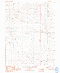
 1991 Crescent Junction1991 Print · USGSGrand County at the start of the nineties centers on the vital transit hub of Crescent Junction and the surrounding desert landscape. Genealogists and historians can trace the paths of the Old RR Grade, find secluded locations like Horse Heaven, and locate the Valley City Reservoir.
 - 1991 Map of Black Knolls
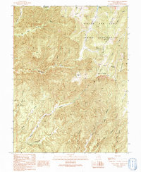
 1991 Black Knolls1991 Print · USGSThe eastern Uinta Basin in the early 1990s is captured here, showing the intersection of the Uintah and Ouray Indian Reservation and the Grand County line. Researchers can map the intricate canyon networks of Upper Wagon Canyon and remote landmarks like Picket Corral Ridge.
 - 1991 Map of Moonwater Point
 1991 Moonwater Point1991 Print · USGSThe Tavaputs Plateau and tribal lands come into focus during the early nineties in this detailed topographical study. Researchers can trace remote trails and essential water sources like Anna Laura Spring, Pinto Springs, and the deep reaches of Moonwater Canyon.
 - 1991 Map of Sagers Flat
 1991 Sagers Flat1991 Print · USGSGrand County's desert transit corridors are captured here in the early nineties, showing where industry meets the arid flats. Genealogists and historians can trace the Old Railroad Grade and explore the drainage systems of Yellow Cat Wash and Salt Wash.
 - 1991 Map of Bobby Canyon North
 1991 Bobby Canyon North1991 Print · USGSGrand County's canyonlands were mapped in high detail during the early nineties, revealing a landscape of remote plateaus and deep drainages. Researchers can trace historical routes through Poverty Bench and locate mineral sites like the Adit and Prospect.
Showing maps 1-25 of 35
Top cities of Grand County
Frequently asked questions
- What are the different types of historical maps available for Grand County?
- What is the oldest map of Grand County?
- Where can I purchase historical maps of Grand County for my home or office?
- Where can I download high-res historical maps of Grand County?
- Are there historical topographic maps available for Grand County?
- Is there historical aerial imagery available for Grand County?
- Where are historical maps of Grand County sourced from?