1991 Map of Thompson Springs
USGS Topo · Published 1991About this map
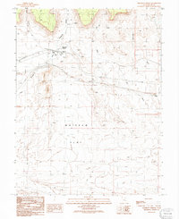
Thompson Springs serves as the focal point of this arid Grand County landscape, where the intersection of transit and utility infrastructure meets the desert floor. The map documents a town layout featuring a Cem, Trailer Park, and a Radio Tower, all positioned near the drainage of Thompson Wash. This 1991 provisional update captures the area's industrial footprint through numerous Prospects and a Pumping Sta, reflecting the ongoing extraction and resource management characteristic of eastern Utah.
Find a feature on this map
22 named features on this map. Tap any name to fly to it.
Don’t see what you’re looking for? This feature index may not catch every label — zoom into the map to look around manually.
Map Details
Editions of this 1991 Thompson Springs Map
This is the sole edition of this map. No revisions or reprints were ever made.
Other maps of this area

1885 · East Tavaputs
USGS Topo · 1:250,000

1885 · La Sal
USGS Topo · 1:250,000

1956 · Moab
USGS Topo · 1:250,000

1956 · Grand Junction
USGS Topo · 1:250,000
1958 · Crescent Junction
USGS Topo · 1:62,500
1958 · Thompson
USGS Topo · 1:62,500

1959 · Grand Junction
USGS Topo · 1:250,000

1959 · Moab
USGS Topo · 1:250,000

1960 · Moab
USGS Topo · 1:250,000

1960 · Grand Junction
USGS Topo · 1:250,000