
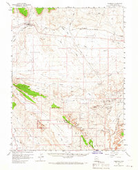
1958 Map of Thompson
USGS Topo · Published 1960About this map
Thompson serves as a central hub for the Denver and Rio Grande Western railroad in this 1958 survey, where the arid high desert landscape is defined by industrial extraction and dramatic geological formations. The northern portion of the map is dominated by the rail line and the tiny stops of Vista and Elba, while the southern reaches reveal the early boundaries and features of Arches National Monument. This area, including the Devils Garden, is home to iconic natural structures like Landscape Arch, Double O Arch, and Skyline Arch.
Find a feature on this map
74 named features on this map. Tap any name to fly to it.
Don’t see what you’re looking for? This feature index may not catch every label — zoom into the map to look around manually.
Map Details
Editions of this 1958 Thompson Map
2 editions found
Other maps of this area

1885 · East Tavaputs
USGS Topo · 1:250,000

1885 · La Sal
USGS Topo · 1:250,000

1951 · The Knoll
USGS Topo · 1:62,500

1952 · Moab 4 NW
USGS Topo · 1:24,000

1952 · Moab 3 NE
USGS Topo · 1:24,000

1954 · Mt. Waas 3 NW
USGS Topo · 1:24,000

1954 · Castle Valley
USGS Topo · 1:62,500

1956 · Moab
USGS Topo · 1:250,000

1956 · Grand Junction
USGS Topo · 1:250,000

1958 · Crescent Junction
USGS Topo · 1:62,500