1940s Maps of Juab County, Utah
Explore 3 historic maps of Juab County from the 1940s. These maps offer a rare glimpse into what life looked like during the 1940s — showing old roads, neighborhoods, homes, and landmarks that have changed or disappeared over time.
Whether you're researching your family's past, planning a metal detecting trip, or studying how Juab County's landscape evolved across the 1940s, these high-resolution maps are a powerful tool for exploring the history of this region.
- Focus on a specific era: All maps on this page are from the 1940s, giving you a focused view of this time period.
- See what’s changed: Compare century-old streets, trails, and buildings to today's modern landscape using overlays and satellite layers.
- Research with precision: Use these maps for genealogy, historical research, land use analysis, or educational projects.
- View, download, or print: Maps are fully viewable online in high resolution, and can be downloaded or printed for your own records.
Start exploring Juab County's history through authentic maps from the 1940s. This is your window into the past.
Juab County, UT maps
(3)- 1947 Map of Fivemile Pass, 1953 Print
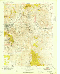
 1947 Fivemile Pass1953 Print · USGSUtah's high desert reveals its mining and transit legacy in the late 1940s as the East Tintic Mountains hum with mineral extraction. Trace the storied Pony Express Route or locate historic operations like the Lehi Tintic Mine and the settlement of Topliff.
 - 1947 Map of Boulter Peak, 1958 Print
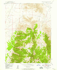 1947 Boulter Peak1958 Print · USGSThe East Tintic Mountains meet the desert basins of Tooele and Juab counties in the late 1940s. Researchers can trace historical mining claims and rugged transportation routes like the Scranton Mine, Twelvemile Pass, and Silver Dollar Mine.2 unique versions available
 - 1949 Map of Eureka
 1949 Eureka1949 Print · USGSThe Tintic mining district was at the height of its industrial reach in the late 1940s, marking a landscape defined by deep shafts and rail lines. You can trace the exact locations of historic operations like Mammoth, the Iron King No 1 Shaft, and the camps at Knightville.
End of results
Showing maps 1-3 of 3
Top cities of Juab County
- Nephi historical maps
- Mona historical maps
- Rocky Ridge historical maps
- Levan historical maps
- Eureka historical maps
Frequently asked questions
- What are the different types of historical maps available for Juab County?
- What is the oldest map of Juab County?
- Where can I purchase historical maps of Juab County for my home or office?
- Where can I download high-res historical maps of Juab County?
- Are there historical topographic maps available for Juab County?
- Is there historical aerial imagery available for Juab County?
- Where are historical maps of Juab County sourced from?