1990s Maps of Salt Lake City, Utah
Explore 7 historic maps of Salt Lake City from the 1990s. These maps offer a rare glimpse into what life looked like during the 1990s — showing old roads, neighborhoods, homes, and landmarks that have changed or disappeared over time.
Whether you're researching your family's past, planning a metal detecting trip, or studying how Salt Lake City's landscape evolved across the 1990s, these high-resolution maps are a powerful tool for exploring the history of this region.
- Focus on a specific era: All maps on this page are from the 1990s, giving you a focused view of this time period.
- See what’s changed: Compare century-old streets, trails, and buildings to today's modern landscape using overlays and satellite layers.
- Research with precision: Use these maps for genealogy, historical research, land use analysis, or educational projects.
- View, download, or print: Maps are fully viewable online in high resolution, and can be downloaded or printed for your own records.
Start exploring Salt Lake City's history through authentic maps from the 1990s. This is your window into the past.
Salt Lake City, UT maps
(7)- 1997 Map of Baileys Lake, 2001 Print
 1997 Baileys Lake2001 Print · USGSThe wetlands of the Great Salt Lake are captured here in the late nineties, showing a landscape of hunting clubs and water management. Trace the Old Railroad Grade and find historic sites like Riter and the Harrison Duck Club.
 - 1998 Map of Salt Lake City North, 2001 Print
 1998 Salt Lake City North2001 Print · USGSSalt Lake City and its northern neighbors appear at the end of the century as the region prepared for the 2002 Winter Olympics. Researchers can trace the massive industrial and transport hubs near Skypark Airport or locate civic landmarks like the State Capitol and the historic Pony Exp Mon.
 - 1998 Map of Mountain Dell, 2001 Print
 1998 Mountain Dell2001 Print · USGSThe high passes and historic migration trails east of Salt Lake City are preserved here in the late nineties. Trace the footsteps of the Mormon Pioneers and locate landmark markers like the Ephraim Hanks Station Pony Express Marker or the Camp Grant Hist Site.
 - 1998 Map of Fort Douglas, 2001 Print
 1998 Fort Douglas2001 Print · USGSThe eastern edges of Salt Lake City and Bountiful meet the high Wasatch front in the late nineties, just as the region prepared for the Winter Olympics. Researchers can trace the boundaries of Fort Douglas, find the City Cemetery, and see the footprint of the Olympic Village.
 - 1998 Map of Sugar House, 2001 Print
 1998 Sugar House2001 Print · USGSSalt Lake City and Murray expand toward the Wasatch Front in the late nineties as the suburban grid meets the wilderness. Trace local heritage at Wheeler Historic Farm, the Sugar House Monument, or find family records at Elysian Burial Gardens and Knudsens Corner.
 - 1999 Map of Salt Lake City South, 2001 Print
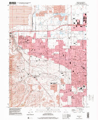
 1999 Salt Lake City South2001 Print · USGSSalt Lake Valley settlement reached a peak of suburban development by the late nineties, filling the space between the river and the western benches. Researchers can trace the evolution of neighborhoods like Taylorsville and Kearns, or locate landmarks such as Franklin Covey Field and Redwood Mem Estates.
 - 1999 Map of Magna, 2001 Print
 1999 Magna2001 Print · USGSThe Salt Lake Valley at the end of the century shows a unique blend of heavy industry and suburban growth. Trace family roots at Pleasant Green Cem or find local landmarks like the Magna Mill and the Utah Olympic Oval.
End of results
Showing maps 1-7 of 7
Top cities near Salt Lake City
- West Valley City historical maps
- West Jordan historical maps
- Sandy historical maps
- South Jordan historical maps
- Millcreek historical maps
- Taylorsville historical maps
See more
Top neighborhoods of Salt Lake City
- Alvin & Helene Richer Commons historical maps
- Kabis and Myers historical maps
- Langton Park historical maps
- Clives historical maps
- Colorado historical maps
- Cone and Roberts Addition historical maps
See more
Frequently asked questions
- What are the different types of historical maps available for Salt Lake City?
- What is the oldest map of Salt Lake City?
- Where can I purchase historical maps of Salt Lake City for my home or office?
- Where can I download high-res historical maps of Salt Lake City?
- Are there historical topographic maps available for Salt Lake City?
- Is there historical aerial imagery available for Salt Lake City?
- Where are historical maps of Salt Lake City sourced from?