1970s Maps of Weber County, Utah
Explore 5 historic maps of Weber County from the 1970s. These maps offer a rare glimpse into what life looked like during the 1970s — showing old roads, neighborhoods, homes, and landmarks that have changed or disappeared over time.
Whether you're researching your family's past, planning a metal detecting trip, or studying how Weber County's landscape evolved across the 1970s, these high-resolution maps are a powerful tool for exploring the history of this region.
- Focus on a specific era: All maps on this page are from the 1970s, giving you a focused view of this time period.
- See what’s changed: Compare century-old streets, trails, and buildings to today's modern landscape using overlays and satellite layers.
- Research with precision: Use these maps for genealogy, historical research, land use analysis, or educational projects.
- View, download, or print: Maps are fully viewable online in high resolution, and can be downloaded or printed for your own records.
Start exploring Weber County's history through authentic maps from the 1970s. This is your window into the past.
Weber County, UT maps
(5)- 1972 Map of Buffalo Point, 1973 Print
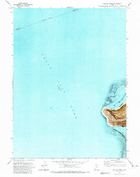 1972 Buffalo Point1973 Print · USGSAntelope Island stands isolated in the Great Salt Lake during the early seventies, just as its northwestern shores were being organized for public use. Trace the natural features of the new Great Salt Lake State Park, including Buffalo Point and the remote Egg Island bird habitat.
 - 1972 Map of Willard Spur, 1973 Print
 1972 Willard Spur1973 Print · USGSThe northern reaches of the Great Salt Lake are defined by industrial salt production and military testing in the early seventies. Trace the expansive Salt Evaporators and the Little Mountain Air Force Training Annex.
 - 1972 Map of Plain City SW, 1974 Print
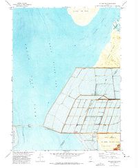
 1972 Plain City SW1974 Print · USGSThe marshy fringes of the Great Salt Lake come into focus in the early seventies, where irrigation canals and salt flats meet growing industrial and military sites. Trace local family roots at West Warren or find records at the Warren Cem near the winding Weber River.
 - 1972 Map of Fremont Island, 1974 Print
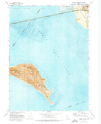 1972 Fremont Island1974 Print · USGSThe eastern reaches of the Great Salt Lake are captured here in the early seventies as industrial salt works and military training grounds bordered the water. Researchers can locate the Lucin Cutoff rail line and isolated island features like Graves and Ruins.
 - 1972 Map of Ogden Bay, 1974 Print
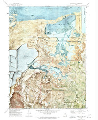
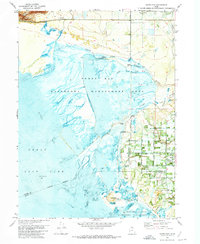 1972 Ogden Bay1974 Print · USGSThe eastern shore of the Great Salt Lake comes into focus in the early seventies, showing a landscape defined by water management and river deltas. Trace the historic Southern Pacific line past Hooper Hot Springs or locate the Hales Bend site.
End of results
Showing maps 1-5 of 5
Top cities of Weber County
- Ogden historical maps
- Roy historical maps
- North Ogden historical maps
- South Ogden historical maps
- Pleasant View historical maps
- Riverdale historical maps
See more
Frequently asked questions
- What are the different types of historical maps available for Weber County?
- What is the oldest map of Weber County?
- Where can I purchase historical maps of Weber County for my home or office?
- Where can I download high-res historical maps of Weber County?
- Are there historical topographic maps available for Weber County?
- Is there historical aerial imagery available for Weber County?
- Where are historical maps of Weber County sourced from?