1950s Maps of Accomack County, Virginia
Explore 10 historic maps of Accomack County from the 1950s. These maps offer a rare glimpse into what life looked like during the 1950s — showing old roads, neighborhoods, homes, and landmarks that have changed or disappeared over time.
Whether you're researching your family's past, planning a metal detecting trip, or studying how Accomack County's landscape evolved across the 1950s, these high-resolution maps are a powerful tool for exploring the history of this region.
- Focus on a specific era: All maps on this page are from the 1950s, giving you a focused view of this time period.
- See what’s changed: Compare century-old streets, trails, and buildings to today's modern landscape using overlays and satellite layers.
- Research with precision: Use these maps for genealogy, historical research, land use analysis, or educational projects.
- View, download, or print: Maps are fully viewable online in high resolution, and can be downloaded or printed for your own records.
Start exploring Accomack County's history through authentic maps from the 1950s. This is your window into the past.
Accomack County, VA maps
(10)- 1953 Map of Boxiron
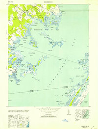 1953 Boxiron1953 Print · USGSCoastal Maryland and Virginia at mid-century reveal a landscape of tidal marshes and remote landings along the Chincoteague Bay. Genealogists and historians can trace old shoreline access points like Truitt Landing and Scarboro Landing near Boxiron.
 - 1953 Map of Girdletree
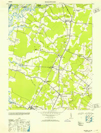
 1953 Girdletree1953 Print · USGSThe Maryland-Virginia borderlands on the Eastern Shore are captured here in the early fifties, where rail and tide met. Genealogists can locate family landmarks from Franklin City to Girdletree, including St Pauls School and Spring Hill Cem.2 unique versions available
 - 1953 Map of Crisfield
 1953 Crisfield1953 Print · USGSMaryland's lower Eastern Shore thrives as a maritime and rail center during the early fifties, where the town meets the marsh. Genealogists and historians can trace the streets of Crisfield, locate the Phoenix Church, or explore the waterfront around Somers Cove and Jersey Island.3 unique versions available
 - 1953 Map of Hallwood
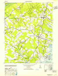
 1953 Hallwood1953 Print · USGSLower Accomack County and the Maryland borderlands are captured here in the early fifties, showing a rural landscape defined by the railroad and tidal creeks. Genealogists can trace family footprints near Jenkins Bridge PO, Greenwood Cem, and the old Tunnels Mill site.
 - 1953 Map of Pocomoke City
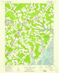
 1953 Pocomoke City1953 Print · USGSMid-century Worcester County comes to life at the Maryland-Virginia line, where the river-bound economy of Pocomoke City meets the deep reaches of Cypress Swamp. Family historians can trace rural landmarks from Tindlys Chapel to the small community at Costen.2 unique versions available
 - 1953 Map of Whittington Point
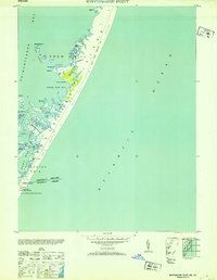 1953 Whittington Point1953 Print · USGSAssateague Island and the coastal marshes of the Maryland-Virginia border are captured here in the mid-century. Historians and researchers can trace the old state line at the Boundary Monument and locate maritime outposts like Pope Coast Guard Station or the remote Scotts Landing.
 - 1957 Map of Salisbury
 1957 Salisbury1957 Print · USGSThe Delmarva Peninsula in the mid-1950s reveals a landscape of coastal defenses and rail-driven commerce. Researchers can trace the Pennsylvania railroad lines or locate historic landmarks like the Fenwick Island Lighthouse and St Martin church.
 - 1957 Map of Accomac, 1958 Print
 1957 Accomac1958 Print · USGSThe Eastern Shore of Virginia comes alive in the late fifties, centered on the Pennsylvania Railroad and the coastal marshes of the Atlantic. Genealogists can trace family footprints through sites like Edge Hill Cem, Smith Sch, and St Peters Chapel.
 - 1957 Map of Metomkin Inlet, 1958 Print
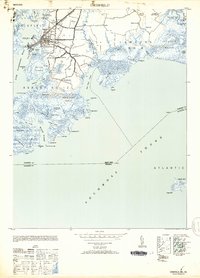
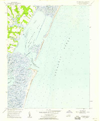 1957 Metomkin Inlet1958 Print · USGSThe Virginia coastline of the late fifties reveals a landscape of shifting barrier islands and tidal marshes before modern coastal changes. Genealogists and historians can trace family land at Parker Neck or locate the Coast Guard Station near Metomkin Inlet.
 - 1959 Map of Richmond
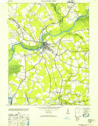
 1959 Richmond1959 Print · USGSMid-century Virginia is captured here at its most vital rail and river junctions, from the capital city to the Chesapeake Bay. Genealogists and historians can trace the development of colonial settlements like Williamsburg and military landmarks including Fort Monroe and Camp Lee.
End of results
Showing maps 1-10 of 10
Top cities of Accomack County
- Chincoteague historical maps
- Captains Cove historical maps
- Wattsville historical maps
- Onancock historical maps
- Horntown historical maps
- Parksley historical maps
See more
Frequently asked questions
- What are the different types of historical maps available for Accomack County?
- What is the oldest map of Accomack County?
- Where can I purchase historical maps of Accomack County for my home or office?
- Where can I download high-res historical maps of Accomack County?
- Are there historical topographic maps available for Accomack County?
- Is there historical aerial imagery available for Accomack County?
- Where are historical maps of Accomack County sourced from?