1930s Maps of Accomack County, Virginia
Explore 3 historic maps of Accomack County from the 1930s. These maps offer a rare glimpse into what life looked like during the 1930s — showing old roads, neighborhoods, homes, and landmarks that have changed or disappeared over time.
Whether you're researching your family's past, planning a metal detecting trip, or studying how Accomack County's landscape evolved across the 1930s, these high-resolution maps are a powerful tool for exploring the history of this region.
- Focus on a specific era: All maps on this page are from the 1930s, giving you a focused view of this time period.
- See what’s changed: Compare century-old streets, trails, and buildings to today's modern landscape using overlays and satellite layers.
- Research with precision: Use these maps for genealogy, historical research, land use analysis, or educational projects.
- View, download, or print: Maps are fully viewable online in high resolution, and can be downloaded or printed for your own records.
Start exploring Accomack County's history through authentic maps from the 1930s. This is your window into the past.
Accomack County, VA maps
(3)- 1931 Map of Accomac
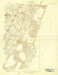 1931 Accomac1931 Print · USGSThe Eastern Shore of Virginia in the early thirties shows a thriving rail corridor and a wild, unbridged Atlantic coast. Genealogists can locate family landmarks like Oak Grove Chapel and Becker Ch or trace the early days of the Keller Fairgrounds.4 unique versions available
 - 1935 Map of Accomac
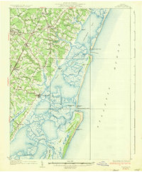 1935 Accomac1935 Print · USGSCoastal Virginia in the mid-thirties was a landscape of deep-rooted maritime traditions and railroad commerce. Genealogists and historians can trace old homesteads near Burton Ch, locate the Fairgrounds at Tasley, or study the barrier islands from Metomkin Island down to Parramore Island.2 unique versions available
 - 1938 Map of Green Run, 1960 Print
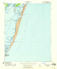 1938 Green Run1960 Print · USGSAssateague Island and the Delmarva coast appear here in the late 1930s, showing a landscape of maritime outposts and undeveloped barrier beaches. Researchers can trace the early locations of North Beach and Green Run Inlet Coast Guard Stations.
End of results
Showing maps 1-3 of 3
Top cities of Accomack County
- Chincoteague historical maps
- Captains Cove historical maps
- Wattsville historical maps
- Onancock historical maps
- Horntown historical maps
- Parksley historical maps
See more
Frequently asked questions
- What are the different types of historical maps available for Accomack County?
- What is the oldest map of Accomack County?
- Where can I purchase historical maps of Accomack County for my home or office?
- Where can I download high-res historical maps of Accomack County?
- Are there historical topographic maps available for Accomack County?
- Is there historical aerial imagery available for Accomack County?
- Where are historical maps of Accomack County sourced from?