1960s Maps of Accomack County, Virginia
Explore 33 historic maps of Accomack County from the 1960s. These maps offer a rare glimpse into what life looked like during the 1960s — showing old roads, neighborhoods, homes, and landmarks that have changed or disappeared over time.
Whether you're researching your family's past, planning a metal detecting trip, or studying how Accomack County's landscape evolved across the 1960s, these high-resolution maps are a powerful tool for exploring the history of this region.
- Focus on a specific era: All maps on this page are from the 1960s, giving you a focused view of this time period.
- See what’s changed: Compare century-old streets, trails, and buildings to today's modern landscape using overlays and satellite layers.
- Research with precision: Use these maps for genealogy, historical research, land use analysis, or educational projects.
- View, download, or print: Maps are fully viewable online in high resolution, and can be downloaded or printed for your own records.
Start exploring Accomack County's history through authentic maps from the 1960s. This is your window into the past.
Accomack County, VA maps
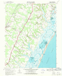
(33)- 1961 Map of Eastville
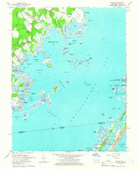
 1961 Eastville1961 Print · USGSThe Eastern Shore and Outer Banks are captured here in the mid-twentieth century, showing a maritime landscape of lighthouses, rail-linked towns, and naval outposts. Researchers can trace the Pennsylvania Railroad through Parksley or locate historical sites like Chincoteague Field Naval Auxiliary Air Station and Tangier Island.
 - 1961 Map of Salisbury
 1961 Salisbury1961 Print · USGSThe Delmarva Peninsula comes into focus in the early sixties, showing the vital road and rail networks connecting the Chesapeake to the Atlantic. Genealogists and historians can trace family-named landings and coastal landmarks from Crisfield to the Brandywine Shoal Lighthouse.
 - 1964 Map of Richmond
 1964 Richmond1964 Print · USGSCoastal and central Virginia are mapped during the mid-twentieth century, showing the critical intersection of rail, river, and military life. Genealogists can trace family roots through rural county seats like Amelia or find vanished coastal neighborhoods near Phoebus and Hilton Village.
 - 1964 Map of Boxiron, 1966 Print
 1964 Boxiron1966 Print · USGSThe Worcester County coast during the mid-sixties reveals a landscape of isolated landings and intricate tidal waterways. Genealogists and historians can trace family-named sites like Scarboro Landing, the settlement of Boxiron, and landmarks such as Tizzard Island.3 unique versions available
 - 1964 Map of Whittington Point, 1966 Print
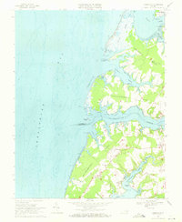
 1964 Whittington Point1966 Print · USGSAssateague Island and the Maryland-Virginia borderlands are captured here in the mid-sixties, showing the wild coastal marshes before modern changes. Local historians can trace the intricate geography of the Chincoteague National Wildlife Refuge and find landmarks like Scotts Landing and Pope Island.4 unique versions available
 - 1965 Map of Chincoteague West
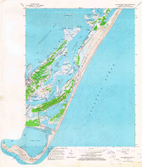
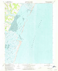
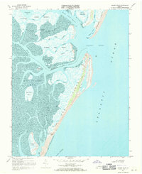
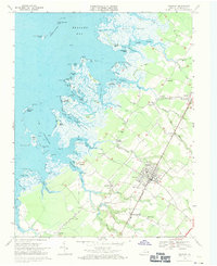
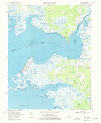
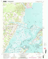 1965 Chincoteague West1965 Print · USGSCoastal Accomack County underwent a significant transformation in the mid-sixties as NASA operations and national seashores expanded. Genealogists and local historians can trace the streets of Chincoteague or locate rural landmarks like Horntown and the Tabernacle Ch.5 unique versions available
 - 1965 Map of Salisbury
 1965 Salisbury1965 Print · USGSThe Delmarva Peninsula in the mid-1960s is depicted here as a landscape of coastal defenses and maritime hubs. Genealogists and local historians can trace the foundations of bayside towns like Crisfield and the tactical positioning of the Fort Miles Military Reservation and Cape May Naval Air Station.
 - 1965 Map of Wallops Island, 1966 Print
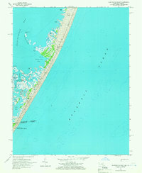
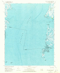
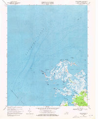
 1965 Wallops Island1966 Print · USGSThe Virginia coastline in the mid-sixties reveals the early technological footprint of the space race amidst the marshes of the Eastern Shore. Researchers can trace the layout of early Launch Pads on Wallops Island and the pristine reaches of Toms Cove.5 unique versions available
 - 1965 Map of Chincoteague East, 1966 Print
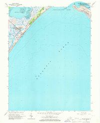
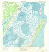
 1965 Chincoteague East1966 Print · USGSThe Virginia coastline comes to life in the mid-1960s, showing the intricate barrier islands and fishing communities of the Eastern Shore. Researchers can trace the streets of Chincoteague, locate family plots at Ridge Cem, or find the Assateague Beach U S Coast Guard Station.4 unique versions available
 - 1966 Map of Eastville
 1966 Eastville1966 Print · USGSThe Delmarva Peninsula and Outer Banks appear in the mid-sixties, showing a landscape of maritime trade, military outposts, and fishing villages. Researchers can trace the lines of the Norfolk & Southern through Exmore and Parksley or locate historical sites like Fort John Custis and the Janes Island Lighthouse.
 - 1966 Map of Girdletree, 1968 Print
 1966 Girdletree1968 Print · USGSThe Maryland-Virginia borderlands of the Eastern Shore come to life in this mid-century survey of the Chincoteague Bay region. Genealogists can trace family footprints across Stockton, Girdletree, and Welbourne, or locate specific sites like the Little Red School and Old Shiloh Cemetery.4 unique versions available
 - 1968 Map of Accomac, 1971 Print
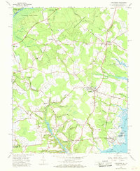
 1968 Accomac1971 Print · USGSThe Virginia Eastern Shore in the late sixties reveals a landscape of tidal marshes and tight-knit railway towns. Genealogists and historians can trace family roots through several landmarks including Edge Hill Cem, St Lukes Ch, and the Penn Central rail corridor.3 unique versions available
 - 1968 Map of Nassawadox, 1971 Print
 1968 Nassawadox1971 Print · USGSThe Virginia Eastern Shore in the late sixties reveals a landscape of railroad towns and sprawling saltwater marshes. Genealogists can trace family roots through Little Johnsontown and Hare Valley, or locate landmarks like Red Bank Ch.2 unique versions available
 - 1968 Map of Metomkin Inlet, 1971 Print
 1968 Metomkin Inlet1971 Print · USGSThe Virginia barrier islands and Accomack mainland are captured here in the late sixties, showing a landscape defined by tidal channels and rural necks. Genealogists and local historians can trace family-named sites like Parker Neck, Joynes Neck, and the settlement of Walston.5 unique versions available
 - 1968 Map of Great Fox Island, 1971 Print
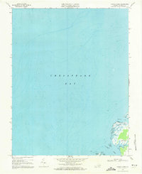
 1968 Great Fox Island1971 Print · USGSChesapeake Bay watermen navigated this intricate network of sounds and marshes in the late sixties. Genealogists and historians can trace the remote outposts of Smith Island, the marshes of Janes Island, and family landmarks like Horse Hammock.3 unique versions available
 - 1968 Map of Nandua Creek, 1971 Print
 1968 Nandua Creek1971 Print · USGSThe Eastern Shore of Virginia meets the bay in the late sixties, where the tide shapes a landscape of marsh and creek. Trace the settlement at Hacksneck or the labyrinth of Nandua Creek, Butcher Creek, and the wetlands of Hyslop Marsh.3 unique versions available
 - 1968 Map of Quinby Inlet, 1971 Print
 1968 Quinby Inlet1971 Print · USGSThe Virginia barrier islands remained a vital maritime landscape in the late sixties, where isolated settlements met the Atlantic. Researchers can trace the layout of Broadwater, find the local Cem, and navigate the complex channels of Quinby Inlet.4 unique versions available
 - 1968 Map of Parksley, 1971 Print
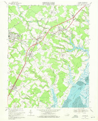
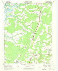
 1968 Parksley1971 Print · USGSThe Virginia Eastern Shore is captured here in the late sixties, showcasing the coastal settlements and rail corridors of Accomack County. Genealogists can trace family names through landmarks like Lee Mont, Wise Chapel, and the Penn Central rail line.4 unique versions available
 - 1968 Map of Hallwood, 1971 Print
 1968 Hallwood1971 Print · USGSIn the late 1960s, the rural corridor of the Virginia Eastern Shore was a landscape of rail-linked hamlets and tidal creeks. Researchers can trace the heritage of local families through landmarks like Jerusalem Ch, Greenwood Cem, and the historic crossing at Jenkins Bridge.4 unique versions available
 - 1968 Map of Wachapreague, 1971 Print
 1968 Wachapreague1971 Print · USGSThe Virginia coast during the late sixties reveals an intricate balance of shorebound settlements and a shifting maritime environment. Researchers can trace family history through sites like Locust Mount and Old Trower, or locate the Parramore Beach Coast Guard Station on the barrier sands.
 - 1968 Map of Chesconessex, 1971 Print
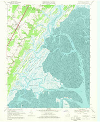
 1968 Chesconessex1971 Print · USGSThe intricate shoreline of Accomack County is captured here in the late sixties, where the Chesapeake meets the sound. You can trace the community around Chesconessex and locate local landmarks like New Testament Ch, Leatherbury Ch, and Savage Island.3 unique versions available
 - 1968 Map of Bloxom, 1971 Print
 1968 Bloxom1971 Print · USGSAccomack County's Atlantic coast is shown here in the late sixties, where rail-side villages meet the tidal marshes. Genealogists and historians can trace long-standing communities like Modest Town, Gargatha, and Guilford along with rural sites like Woodbury Ch.4 unique versions available
 - 1968 Map of Jamesville, 1971 Print
 1968 Jamesville1971 Print · USGSThe Eastern Shore of Virginia in the late sixties reveals a landscape of tidal inlets and historic waterfront landings. Genealogists and local historians can trace family roots through settlements like Jamesville and Hacks Neck, or locate old gathering places like Bethel Ch and Morleys Wharf.4 unique versions available
 - 1968 Map of Pungoteague, 1972 Print
 1968 Pungoteague1972 Print · USGSVirginia's Eastern Shore shoreline and its peninsula communities are preserved here in the late sixties. Trace family roots and local history through Pungoteague, Savageville, and Hacksneck, or locate old landmarks like St Georges Ch and the South Accomack Sch.3 unique versions available
 - 1968 Map of Saxis, 1972 Print
 1968 Saxis1972 Print · USGSThe Virginia-Maryland borderlands of the late sixties are captured here, showing the delicate balance of life along Pocomoke Sound. Genealogists and local historians can trace family-named sites like Pitts Neck or visit coastal settlements such as Saxis and Sanford.3 unique versions available
Showing maps 1-25 of 33
Top cities of Accomack County
- Chincoteague historical maps
- Captains Cove historical maps
- Wattsville historical maps
- Onancock historical maps
- Horntown historical maps
- Parksley historical maps
See more
Frequently asked questions
- What are the different types of historical maps available for Accomack County?
- What is the oldest map of Accomack County?
- Where can I purchase historical maps of Accomack County for my home or office?
- Where can I download high-res historical maps of Accomack County?
- Are there historical topographic maps available for Accomack County?
- Is there historical aerial imagery available for Accomack County?
- Where are historical maps of Accomack County sourced from?