1980s Maps of Accomack County, Virginia
Explore 9 historic maps of Accomack County from the 1980s. These maps offer a rare glimpse into what life looked like during the 1980s — showing old roads, neighborhoods, homes, and landmarks that have changed or disappeared over time.
Whether you're researching your family's past, planning a metal detecting trip, or studying how Accomack County's landscape evolved across the 1980s, these high-resolution maps are a powerful tool for exploring the history of this region.
- Focus on a specific era: All maps on this page are from the 1980s, giving you a focused view of this time period.
- See what’s changed: Compare century-old streets, trails, and buildings to today's modern landscape using overlays and satellite layers.
- Research with precision: Use these maps for genealogy, historical research, land use analysis, or educational projects.
- View, download, or print: Maps are fully viewable online in high resolution, and can be downloaded or printed for your own records.
Start exploring Accomack County's history through authentic maps from the 1980s. This is your window into the past.
Accomack County, VA maps
(9)- 1981 Map of Cheriton
 1981 Cheriton1981 Print · USGSThe Virginia Eastern Shore in the early eighties is mapped here at the junction of the bay and ocean. Researchers can trace the coastal heritage of the peninsula through landmarks like the Cape Charles Light and settlements such as Oyster, Townsend, and Eastville.
 - 1981 Map of Chincoteague, 1982 Print
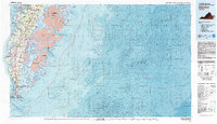
 1981 Chincoteague1982 Print · USGSThe Delmarva Eastern Shore at the start of the eighties shows a unique blend of traditional coastal life and modern aerospace technology. Researchers can trace the Penn Central rail line through rural towns like Modest Town and Bloxom or explore the marshlands of the Saxis Marsh Waterfowl Management Area and Refuge.
 - 1983 Map of Salisbury, 1984 Print
 1983 Salisbury1984 Print · USGSThe Lower Eastern Shore was a landscape of tide and timber in the early eighties, from the bustling streets of Salisbury to the wild coast of Assateague Island. Researchers can trace the rail-and-road network of the Conrail and U S Highway 50 while locating historic centers like Princess Anne and Crisfield.
 - 1984 Map of Tappahannock
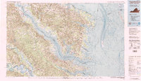 1984 Tappahannock1984 Print · USGSThe Northern Neck and Middle Peninsula of Virginia are captured in detail during the mid-1980s, showcasing the region's deep-rooted maritime and agricultural identity. Genealogists and local historians can trace family locations across the intricate shorelines of the Rappahannock River and settlements like Kilmarnock, Heathsville, and Urbanna.3 unique versions available
 - 1984 Map of Chincoteague
 1984 Chincoteague1984 Print · USGSThe Virginia Eastern Shore and Delmarva Peninsula are captured here in the mid-1980s, showcasing a landscape of barrier islands and tidewater towns. Researchers can trace the Penn Central rail line through Accomac or locate the Wallops Flight Facility (NASA) and Chincoteague Nat Wildlife Refuge.2 unique versions available
 - 1986 Map of East of Deltaville, 1987 Print
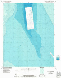
 1986 East of Deltaville1987 Print · USGSThe Virginia coastline and the depths of the Chesapeake Bay are documented in this mid-eighties hydrographic survey. Maritime historians and researchers can trace the underwater contours of the Rappahannock and the submerged landforms of the Spit.2 unique versions available
 - 1986 Map of East of Fleets Bay, 1987 Print
 1986 East of Fleets Bay1987 Print · USGSCoastal Virginia waters in the 1980s come into focus through this detailed bathymetric survey of the Chesapeake Bay. Maritime historians and researchers can study the underwater relief of a large Disposal Area and the location of a deep Channel.2 unique versions available
 - 1986 Map of West of Jamesville, 1987 Print
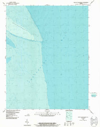
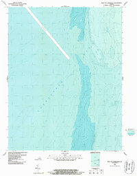 1986 West of Jamesville1987 Print · USGSChesapeake Bay maritime history is preserved in this late-twentieth-century bathymetric survey of the Accomack County coastline. Researchers can trace deep-water navigation routes through the Channel and study the submerged contours of the Chesapeake Bay.2 unique versions available
 - 1986 Map of West of Nandua Creek, 1987 Print
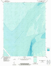 1986 West of Nandua Creek1987 Print · USGSThe waters off the Eastern Shore of Virginia are captured in this mid-eighties bathymetric survey. Researchers can trace the depth contours of the Chesapeake Bay and the position of the major deep-water Channel during this era.2 unique versions available
End of results
Showing maps 1-9 of 9
Top cities of Accomack County
- Chincoteague historical maps
- Captains Cove historical maps
- Wattsville historical maps
- Onancock historical maps
- Horntown historical maps
- Parksley historical maps
See more
Frequently asked questions
- What are the different types of historical maps available for Accomack County?
- What is the oldest map of Accomack County?
- Where can I purchase historical maps of Accomack County for my home or office?
- Where can I download high-res historical maps of Accomack County?
- Are there historical topographic maps available for Accomack County?
- Is there historical aerial imagery available for Accomack County?
- Where are historical maps of Accomack County sourced from?