1940s Maps of Clallam County, Washington
Explore 14 historic maps of Clallam County from the 1940s. These maps offer a rare glimpse into what life looked like during the 1940s — showing old roads, neighborhoods, homes, and landmarks that have changed or disappeared over time.
Whether you're researching your family's past, planning a metal detecting trip, or studying how Clallam County's landscape evolved across the 1940s, these high-resolution maps are a powerful tool for exploring the history of this region.
- Focus on a specific era: All maps on this page are from the 1940s, giving you a focused view of this time period.
- See what’s changed: Compare century-old streets, trails, and buildings to today's modern landscape using overlays and satellite layers.
- Research with precision: Use these maps for genealogy, historical research, land use analysis, or educational projects.
- View, download, or print: Maps are fully viewable online in high resolution, and can be downloaded or printed for your own records.
Start exploring Clallam County's history through authentic maps from the 1940s. This is your window into the past.
Clallam County, WA maps
(14)- 1940 Map of Quilcene
 1940 Quilcene1940 Print · USGSThe Olympic Peninsula shoreline and timbered foothills are captured here during the late pre-war era, from the heights of Mt Walker to the depths of Dabob Bay. Researchers can trace early logging operations at Mc Cormack Lumber Co or locate civic landmarks like the Port Townsend Dam and US Fish Hatchery.
 - 1941 Map of Port Angeles, 1958 Print
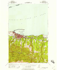 1941 Port Angeles1958 Print · USGSPort Angeles and its harbor stood as a gateway to the Olympic Peninsula in the early 1940s, balancing industrial shipping with rugged forest terrain. Genealogists and historians can locate family landmarks like Krajewski Ranch, the Fairview Sch, and the Angeles L H at the end of Ediz Hook.
 - 1942 Map of Pysht
 1942 Pysht1942 Print · USGSCoastal Clallam County during the early 1940s reveals a landscape defined by industrial timber harvesting and rugged Olympic Peninsula topography. Genealogists and historians can trace the Bloedel Donovan Lumber Mills Logging RR or locate the Indian Cem near the mouth of the Pysht River.
 - 1942 Map of Clallam
 1942 Clallam1942 Print · USGSThe northern Olympic Peninsula coastline is captured here during the early war years, showing the international boundary across the Strait of Juan de Fuca. Genealogists can trace early homesteads like Lambs Ranch and the Kenneth Cowan Ranch, alongside coastal landmarks like Hoko and Sekiu.
 - 1942 Map of Mount Olympus
 1942 Mount Olympus1942 Print · USGSThe high peaks and glaciers of the Olympic Peninsula are captured here during the 1930s, showing a land of deep ice and early mountain outposts. Researchers can trace historic backcountry sites like Olympic Hot Springs, Humes Ranch, and the Olympus Guard Station.
 - 1942 Map of Ozette Lake
 1942 Ozette Lake1942 Print · USGSThe Olympic Peninsula's remote coastal frontier is preserved here during the early war years, centered on the waters of Ozette Lake. Researchers can trace early family homesteads like Rooses Prairie and locate the Abandoned Indian Village at Cape Alava.
 - 1942 Map of Lake Pleasant
 1942 Lake Pleasant1942 Print · USGSThe interior of the Olympic Peninsula comes into focus just before the mid-forties, showing a landscape defined by timber and transit. You can trace the path of the U.S. Government Spruce Canal and locate family landmarks like the Maxfield Ranch or Beaver Sch.
 - 1943 Map of Richardson
 1943 Richardson1943 Print · USGSLopez Island and the surrounding San Juan archipelago are captured here in the early forties, showing a coastal landscape of maritime hamlets and isolated island life. You can trace early school sites like Center Sch and the harbor at Richardson, or locate the remote Smith Island National Wild Life Refuge.
 - 1943 Map of Spruce Mountain
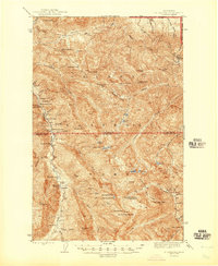
 1943 Spruce Mountain1943 Print · USGSJefferson and Clallam Counties during the wartime era show a landscape of deep timber and isolated homesteads. Researchers can locate remote family holdings like the Huelsdonk Ranch and Schmidt Ranch or trace trails to the Bogachiel Guard Station.
 - 1943 Map of Copalis Beach
 1943 Copalis Beach1943 Print · USGSThe Washington coast in the 1940s is detailed here from the Olympic Peninsula to the Columbia River. Trace old beach settlements like Moclips and Copalis Beach alongside landmarks like the Willapa Bay Lighthouse.
 - 1944 Map of Mt. Angeles, 1957 Print
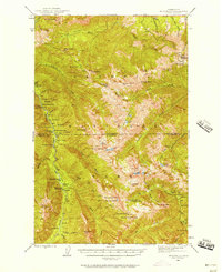 1944 Mt. Angeles1957 Print · USGSThe Olympic Peninsula interior was a network of remote ranger stations and wilderness camps during the mid-twentieth century. Researchers can locate early backcountry infrastructure including Elkhorn Guard Sta, Drums Cabin, and the high-elevation Deer Park Lookout.3 unique versions available
 - 1946 Map of Mt. Angeles
 1946 Mt. Angeles1946 Print · USGSThe Olympic interior in the mid-forties remains a wilderness of remote ranger outposts and mountaineer camps. Trace early park infrastructure from Deer Park Lookout to isolated sites like Remanns Cabin and Drums Cabin.2 unique versions available
 - 1946 Map of Tyler Peak, 1955 Print
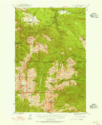 1946 Tyler Peak1955 Print · USGSThe high Olympic wilderness of the mid-forties is documented here just as backcountry recreation and park administration were expanding. Researchers can trace historic shelters and mining interests like the Tubal Cain Mine, Camp Mystery, and Slab Camp Guard Sta.3 unique versions available
 - 1948 Map of Tyler Peak
 1948 Tyler Peak1948 Print · USGSThe high Olympic wilderness of the late 1940s is shown here through its network of forest guard stations and remote backcountry camps. Researchers can trace historic trails to the Tubal Cain Mine, Royal Creek Cabin, and Louella Guard Sta.
End of results
Showing maps 1-14 of 14
Top cities of Clallam County
- Port Angeles historical maps
- Sequim historical maps
- Forks historical maps
- Neah Bay historical maps
- Clallam Bay historical maps
- Blyn historical maps
See more
Frequently asked questions
- What are the different types of historical maps available for Clallam County?
- What is the oldest map of Clallam County?
- Where can I purchase historical maps of Clallam County for my home or office?
- Where can I download high-res historical maps of Clallam County?
- Are there historical topographic maps available for Clallam County?
- Is there historical aerial imagery available for Clallam County?
- Where are historical maps of Clallam County sourced from?