1980s Maps of Clallam County, Washington
Explore 27 historic maps of Clallam County from the 1980s. These maps offer a rare glimpse into what life looked like during the 1980s — showing old roads, neighborhoods, homes, and landmarks that have changed or disappeared over time.
Whether you're researching your family's past, planning a metal detecting trip, or studying how Clallam County's landscape evolved across the 1980s, these high-resolution maps are a powerful tool for exploring the history of this region.
- Focus on a specific era: All maps on this page are from the 1980s, giving you a focused view of this time period.
- See what’s changed: Compare century-old streets, trails, and buildings to today's modern landscape using overlays and satellite layers.
- Research with precision: Use these maps for genealogy, historical research, land use analysis, or educational projects.
- View, download, or print: Maps are fully viewable online in high resolution, and can be downloaded or printed for your own records.
Start exploring Clallam County's history through authentic maps from the 1980s. This is your window into the past.
Clallam County, WA maps
(27)- 1981 Map of Forks, 1982 Print
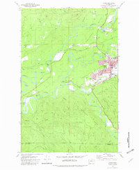 1981 Forks1982 Print · USGSThe convergence of the Soleduck River, Calawah River, and Bogachiel River defines this Olympic Peninsula town in the early eighties. Trace local landmarks like the Community Hosp, Municipal Airport, and the Old RR Grade.
 - 1981 Map of Reade Hill, 1982 Print
 1981 Reade Hill1982 Print · USGSThe Olympic Peninsula logging town of Forks is shown in the early eighties as it expanded into the surrounding timberlands. Genealogists and local historians can trace the early streets of Forks, the local Cem, and the recreation sites at Bogachiel State Park.
 - 1982 Map of La Push
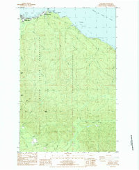
 1982 La Push1982 Print · USGSCoastal Clallam County in the early eighties shows the intersection of tribal lands and federal wilderness at the mouth of the Quillayute River. Local historians can trace the development of La Push including its US Coast Guard Station and the Chilean Memorial Monument.2 unique versions available
 - 1982 Map of Quillayute Prairie
 1982 Quillayute Prairie1982 Print · USGSThe coastal Olympic Peninsula in the early eighties shows the junction of the Bogachiel and Soleduck Rivers near the Pacific Ocean. Researchers can trace the layout of the Quileute Indian Reservation, the Quillayute Cem, and the historical Mora (Site).2 unique versions available
 - 1984 Map of Clallam Bay
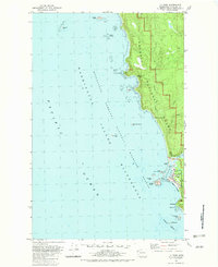
 1984 Clallam Bay1984 Print · USGSCoastal life in the mid-1980s along the Olympic Peninsula is centered on the maritime settlements of Sekiu and Clallam Bay. Researchers can trace the river systems of the Hoko River and find landmarks like Slip Point and the Sekiu Airport.
 - 1984 Map of Deadmans Hill
 1984 Deadmans Hill1984 Print · USGSIn the mid-1980s, the timberlands of Clallam County maintained a network of mountain passes and old logging infrastructure. Researchers can trace the Old R.R. Grade and identify local landmarks like Balch Bridge, Beaver Lake, and the Bear Springs Rearing Pond.2 unique versions available
 - 1984 Map of Gunderson Mtn
 1984 Gunderson Mtn1984 Print · USGSClallam County’s timber and river country is captured here in the mid-eighties, showing the intersection of the Dickey and Soleduck watersheds. You can trace old logging railroad grades through the woods or locate former settlement sites like Dickey Camp and landmarks such as Maxfield Prairie.
 - 1984 Map of Umbrella Creek
 1984 Umbrella Creek1984 Print · USGSThe Clallam County coast in the early eighties was a landscape of dense timber and intricate wetlands. Genealogists and local historians can trace the hydrology of Cranberry Bog, identify industrial sites like the Solberg area, and explore the northern edge of Olympic Nat Park.
 - 1984 Map of Ozette
 1984 Ozette1984 Print · USGSThe westernmost edge of the Olympic Peninsula is captured here in the mid-1980s, where the Ozette Indian Reservation meets the Pacific. Trace local history through the Old RR Grade, the Foot Trail to Cape Alava, and family-named landmarks like Rooses Prairie.
 - 1984 Map of Snider Peak
 1984 Snider Peak1984 Print · USGSThe Olympic Peninsula interior is shown here in the early 1980s, centered on the timbered ridges and river valleys of Clallam County. Local historians and hikers can trace the Old Railroad Grade and locate features like the Snider FS Station and Klahowya Campground.
 - 1984 Map of Makah Bay
 1984 Makah Bay1984 Print · USGSThe rugged coast of Clallam County is meticulously detailed during the early eighties, showing the tribal lands and military outposts at the edge of the Pacific. Local historians can trace the shoreline from Cape Flattery down to Shi Shi Beach, locating landmarks like Meg's Shipwreck and the Makah Air Force Station.
 - 1984 Map of West of Pysht
 1984 West of Pysht1984 Print · USGSThe Olympic Peninsula shoreline meets the Strait of Juan de Fuca in the early 1980s, revealing a landscape of dense forests and coastal drainages. Trace the timber and resource history of Clallam County along the Pysht River and near Burnt Mountain.
 - 1984 Map of Neah Bay
 1984 Neah Bay1984 Print · USGSCoastal Washington at the edge of the Makah Indian Reservation is detailed in the early eighties. Researchers can trace the path of the Old RR Gr, locate the Neah Bay Coast Guard Station, and find local landmarks like Sooes Peak.
 - 1984 Map of Dickey Lake
 1984 Dickey Lake1984 Print · USGSThe Olympic Peninsula timberlands and the eastern shore of Ozette Lake are captured here during the mid-1980s. Researchers can trace the legacy of logging through the Old RR Grade and find family-named landmarks like Birkestol Hill.
 - 1984 Map of Waadah Island
 1984 Waadah Island1984 Print · USGSThe international border across the Strait of Juan de Fuca is captured here in the mid-eighties. Researchers can trace maritime infrastructure at Neah Bay, including the US Coast Guard Reservation and Waadah Island.
 - 1984 Map of Allens Bay
 1984 Allens Bay1984 Print · USGSThe Olympic Peninsula coast in the mid-eighties was a wilderness of protected shoreline and small mining claims. Researchers can locate the Starbuck Mine (Site), the maritime Norwegian Memorial, and the secluded Ericsons Bay Campground.
 - 1984 Map of Bodelteh Islands
 1984 Bodelteh Islands1984 Print · USGSThe Clallam County coastline in the mid-1980s reveals a protected maritime wilderness of isolated rock outcroppings and islands. Researchers can locate specific offshore landmarks like Bodelteh Islands, Ozette Island, and the surrounding Flattery Rocks.
 - 1984 Map of Hoko Falls
 1984 Hoko Falls1984 Print · USGSClallam County’s rugged timberlands are captured here in the mid-1980s, showing a landscape defined by industrial forestry and historical transit. Local researchers can trace the Old Railroad Grade past Hoko Camp and find the site of Old Royal.
 - 1984 Map of Sekiu River
 1984 Sekiu River1984 Print · USGSThe Clallam County coast meets the Strait of Juan de Fuca in this mid-eighties topographic study. Genealogists and local historians can trace the course of the Sekiu River and find landmarks like Shipwreck Point and an abandoned landing strip.
 - 1984 Map of Lake Pleasant
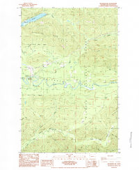
 1984 Lake Pleasant1984 Print · USGSThe Olympic Peninsula timberlands and the Soleduck River corridor are captured here during the mid-eighties. Researchers can trace the legacy of regional logging via the Old Railroad Grade or locate local landmarks like Sappho and the Soleduck Salmon Hatchery.
 - 1984 Map of Slip Point
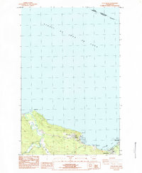
 1984 Slip Point1984 Print · USGSThe maritime boundary between Washington and British Columbia stretches across the water in this mid-eighties survey of the Olympic Peninsula coast. You can trace the shoreline at Slip Point, finding the Slip Point Lighthouse and the Clallam River mouth.
 - 1984 Map of Pysht
 1984 Pysht1984 Print · USGSThe Clallam County coastline comes into focus in the mid-1980s, centered on the historic timber community of Pysht. Researchers can trace the river forks and coastal landmarks like Pillar Point, Butler Cove, and the Pysht Millpond.
 - 1984 Map of Cape Flattery
 1984 Cape Flattery1984 Print · USGSThe northwest tip of the Olympic Peninsula is captured here in the mid-1980s at the meeting of the Pacific and the Strait of Juan de Fuca. Maritime historians and genealogists can locate the Lighthouse on Tatoosh Island, the US Coast Guard Reservation, and coastal Makah sites like Warmhouse Beach.
 - 1984 Map of Ellis Mountain
 1984 Ellis Mountain1984 Print · USGSIn the early 1980s, this area of Clallam County was defined by its timberlands and the headwaters of the Hoko and Clallam rivers. Researchers can locate the Old Clallam Bay Cemetery and trace the paths of Ellis Creek and the Pysht River.
 - 1986 Map of Cape Flattery, 1987 Print
 1986 Cape Flattery1987 Print · USGSThe tip of the Olympic Peninsula and the waters of the Strait of Juan de Fuca are captured here in the mid-eighties. Researchers can trace tribal lands like the Makah Indian Reservation, the remote Old Royal settlement, and maritime landmarks like Cemetery Point.
Showing maps 1-25 of 27
Top cities of Clallam County
- Port Angeles historical maps
- Sequim historical maps
- Forks historical maps
- Neah Bay historical maps
- Clallam Bay historical maps
- Blyn historical maps
See more
Frequently asked questions
- What are the different types of historical maps available for Clallam County?
- What is the oldest map of Clallam County?
- Where can I purchase historical maps of Clallam County for my home or office?
- Where can I download high-res historical maps of Clallam County?
- Are there historical topographic maps available for Clallam County?
- Is there historical aerial imagery available for Clallam County?
- Where are historical maps of Clallam County sourced from?