Old Maps of Clallam County, Washington for Academic Research
Study the evolution of Clallam County with 193 high-resolution historic maps. Whether you're teaching, researching, or modeling changes in land use, these maps provide essential visual documentation of urban, environmental, and geographic change.
- Analyze long-term change: Track patterns in development, transportation, and natural features.
- Ideal for environmental or urban studies: Support academic projects with primary historical map data.
- Use in the classroom or lab: Educators and researchers rely on these maps to bring historical context to life.
These maps are a powerful tool for teaching, research, and visualizing how Clallam County has changed over the decades.
Clallam County, WA maps
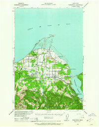
(193)- 1918 Map of Port Angeles
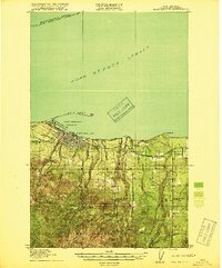 1918 Port Angeles1918 Print · USGSThe northern Olympic Peninsula comes to life in the years following the Great War, showing a landscape defined by maritime trade and logging. Genealogists and historians can locate early landmarks like Reeveton, the Ennis Creek Ranger Station, and several rural schools including Fairview School.4 unique versions available
 - 1918 Map of Lake Crescent, 1958 Print
 1918 Lake Crescent1958 Print · USGSThe northern Olympic Peninsula in the early twentieth century was a landscape of deep glacial lakes and heavy timber industry. Genealogists and historians can trace rail-era settlements like Gettysburg and Fairholm, or locate old landmarks like Twin School and the Crescent Lake Tavern.
 - 1919 Map of Port Crescent
 1919 Port Crescent1919 Print · USGSThe northern Olympic Peninsula comes alive in this survey, showing the shoreline from Agate Bay to Freshwater Bay. Trace the early timber economy through the Logging RR and find vanished sites like Port Crescent or the East Beach ferry landing.4 unique versions available
 - 1922 Map of Pysht
 1922 Pysht1922 Print · USGSCoastal timber country on the Olympic Peninsula comes to life in the early twentieth century, showing the interface between the Juan de Fuca Strait and the deep woods. Trace the path of the Logging R. R. and locate remote outposts like Snider Ranger Sta and Pysht.3 unique versions available
 - 1922 Map of Lake Crescent
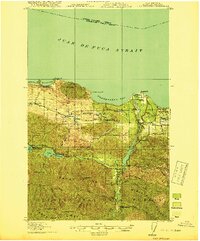
 1922 Lake Crescent1922 Print · USGSCoastal Clallam County at the start of the 1920s shows a rugged landscape of timber railroads and lakeside resorts. Genealogists and historians can locate early landmarks like Twin School, Grubbs Landing, and the Crescent Lake Tavern.3 unique versions available
 - 1935 Map of Clallam, 1947 Print
 1935 Clallam1947 Print · USGSThe Olympic Peninsula coast at the start of the mid-century era shows a landscape of isolated homesteads and maritime landings. Researchers can trace the early footprints of coastal ranching at the George Clarke Ranch or locate the historic timber and fishing hubs of Sekiu and Clallam Bay.
 - 1935 Map of Mount Olympus, 1954 Print
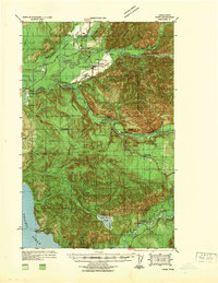
 1935 Mount Olympus1954 Print · USGSThe high peaks and glaciers of the Olympic Range are shown here as they appeared in the 1930s. Researchers can locate remote backcountry landmarks like Michaels Ranch, the Olympus Guard Station, and the old Hurricane Hill Lookout.
 - 1935 Map of Ozette Lake, 1957 Print
 1935 Ozette Lake1957 Print · USGSCoastal Clallam County at the mid-thirties reveals a landscape of isolated homesteads and ancient village sites along the Pacific. Researchers can locate family landmarks like Pete Rooses Ranch and the Old Cemetery near the Ozette Indian Reservation.2 unique versions available
 - 1935 Map of Lake Pleasant, 1958 Print
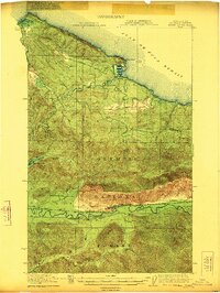
 1935 Lake Pleasant1958 Print · USGSThe Olympic Peninsula's logging and ranching frontier is captured here in the mid-1930s. Genealogists and historians can trace family sites like Klahoose Ranch and timber infrastructure including the Big Creek Shingle Mill and several logging railroads.
 - 1938 Map of Cape Flattery
 1938 Cape Flattery1938 Print · USGSThe Makah Reservation and the extreme northwestern tip of Washington are captured here in the late 1930s. Genealogists can trace early homesteads like Tylers Ranch and Holdens Ranch, or locate community landmarks such as Washburns Cannery and the Neah Bay S H.
 - 1938 Map of Mt Constance
 1938 Mt Constance1938 Print · USGSThe eastern Olympic Peninsula comes into focus in the 1930s as a land of massive peaks and nascent federal parks. Trace the early mining efforts at the Tubal Cain Mine, lookouts like Deer Park Lookout, and the shoreline at Eldon.4 unique versions available
 - 1938 Map of Dungeness, 1961 Print
 1938 Dungeness1961 Print · USGSThe northern Olympic Peninsula coastline in the late 1930s shows a landscape of coastal ranches and railroad-dependent towns. Researchers can trace early family holdings like the McNair Ranch or locate historical maritime markers such as the Dungeness L. H. and the vanished rail stops of the Chicago Milwaukee St Paul and Pacific.2 unique versions available
 - 1939 Map of Port Townsend
 1939 Port Townsend1939 Print · USGSCoastal Jefferson County in the late 1930s serves as a vital maritime and military hub at the edge of the Strait of Juan de Fuca. Genealogists and historians can trace family-named sites like Clark Farm alongside major landmarks like Fort Worden and the busy docks of Irondale.
 - 1939 Map of Forks
 1939 Forks1939 Print · USGSThe Olympic Peninsula logging and oil frontier comes into focus here just before the Second World War. Researchers can trace family homesteads like the Otto Dimmel Ranch alongside industrial landmarks like the Bloedel Donovan Beaver Camp and Oil City Camp.
 - 1939 Map of Dungeness
 1939 Dungeness1939 Print · USGSCoastal Clallam County comes alive in the late thirties as a landscape of maritime navigation and valley ranching. Genealogists and historians can locate family landmarks like the McNair Ranch, rural schoolhouses such as Carlsborg Sch, and the winding Old Olympia Highway.
 - 1939 Map of Mount Tom
 1939 Mount Tom1939 Print · USGSThe Olympic Peninsula wilderness comes into sharp focus during the late 1930s as park and forest boundaries are established. Researchers can trace early trail networks connecting Sol Duc Hot Springs, Mt Tom Shelter, and remote guard stations like Eagle GS.
 - 1940 Map of Quilcene
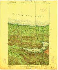
 1940 Quilcene1940 Print · USGSThe Olympic Peninsula shoreline and timbered foothills are captured here during the late pre-war era, from the heights of Mt Walker to the depths of Dabob Bay. Researchers can trace early logging operations at Mc Cormack Lumber Co or locate civic landmarks like the Port Townsend Dam and US Fish Hatchery.
 - 1941 Map of Port Angeles, 1958 Print
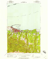 1941 Port Angeles1958 Print · USGSPort Angeles and its harbor stood as a gateway to the Olympic Peninsula in the early 1940s, balancing industrial shipping with rugged forest terrain. Genealogists and historians can locate family landmarks like Krajewski Ranch, the Fairview Sch, and the Angeles L H at the end of Ediz Hook.
 - 1942 Map of Pysht
 1942 Pysht1942 Print · USGSCoastal Clallam County during the early 1940s reveals a landscape defined by industrial timber harvesting and rugged Olympic Peninsula topography. Genealogists and historians can trace the Bloedel Donovan Lumber Mills Logging RR or locate the Indian Cem near the mouth of the Pysht River.
 - 1942 Map of Clallam
 1942 Clallam1942 Print · USGSThe northern Olympic Peninsula coastline is captured here during the early war years, showing the international boundary across the Strait of Juan de Fuca. Genealogists can trace early homesteads like Lambs Ranch and the Kenneth Cowan Ranch, alongside coastal landmarks like Hoko and Sekiu.
 - 1942 Map of Mount Olympus
 1942 Mount Olympus1942 Print · USGSThe high peaks and glaciers of the Olympic Peninsula are captured here during the 1930s, showing a land of deep ice and early mountain outposts. Researchers can trace historic backcountry sites like Olympic Hot Springs, Humes Ranch, and the Olympus Guard Station.
 - 1942 Map of Ozette Lake
 1942 Ozette Lake1942 Print · USGSThe Olympic Peninsula's remote coastal frontier is preserved here during the early war years, centered on the waters of Ozette Lake. Researchers can trace early family homesteads like Rooses Prairie and locate the Abandoned Indian Village at Cape Alava.
 - 1942 Map of Lake Pleasant
 1942 Lake Pleasant1942 Print · USGSThe interior of the Olympic Peninsula comes into focus just before the mid-forties, showing a landscape defined by timber and transit. You can trace the path of the U.S. Government Spruce Canal and locate family landmarks like the Maxfield Ranch or Beaver Sch.
 - 1943 Map of Richardson
 1943 Richardson1943 Print · USGSLopez Island and the surrounding San Juan archipelago are captured here in the early forties, showing a coastal landscape of maritime hamlets and isolated island life. You can trace early school sites like Center Sch and the harbor at Richardson, or locate the remote Smith Island National Wild Life Refuge.
 - 1943 Map of Spruce Mountain
 1943 Spruce Mountain1943 Print · USGSJefferson and Clallam Counties during the wartime era show a landscape of deep timber and isolated homesteads. Researchers can locate remote family holdings like the Huelsdonk Ranch and Schmidt Ranch or trace trails to the Bogachiel Guard Station.
Showing maps 1-25 of 193
Top cities of Clallam County
- Port Angeles historical maps
- Sequim historical maps
- Forks historical maps
- Neah Bay historical maps
- Clallam Bay historical maps
- Blyn historical maps
See more
Frequently asked questions
- What are the different types of historical maps available for Clallam County?
- What is the oldest map of Clallam County?
- Where can I purchase historical maps of Clallam County for my home or office?
- Where can I download high-res historical maps of Clallam County?
- Are there historical topographic maps available for Clallam County?
- Is there historical aerial imagery available for Clallam County?
- Where are historical maps of Clallam County sourced from?