1960s Maps of Clallam County, Washington
Explore 7 historic maps of Clallam County from the 1960s. These maps offer a rare glimpse into what life looked like during the 1960s — showing old roads, neighborhoods, homes, and landmarks that have changed or disappeared over time.
Whether you're researching your family's past, planning a metal detecting trip, or studying how Clallam County's landscape evolved across the 1960s, these high-resolution maps are a powerful tool for exploring the history of this region.
- Focus on a specific era: All maps on this page are from the 1960s, giving you a focused view of this time period.
- See what’s changed: Compare century-old streets, trails, and buildings to today's modern landscape using overlays and satellite layers.
- Research with precision: Use these maps for genealogy, historical research, land use analysis, or educational projects.
- View, download, or print: Maps are fully viewable online in high resolution, and can be downloaded or printed for your own records.
Start exploring Clallam County's history through authentic maps from the 1960s. This is your window into the past.
Clallam County, WA maps
(7)- 1961 Map of Ediz Hook
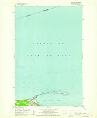 1961 Ediz Hook1961 Print · USGSPort Angeles and its protected harbor are shown in the early 1960s, dominated by the long protective reach of Ediz Hook. Local historians can trace the waterfront development, including the Coast Guard Sta and the Old Railroad Grade that served the city's early industry.2 unique versions available
 - 1961 Map of Port Angeles
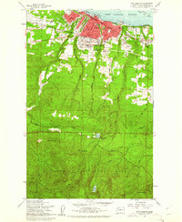 1961 Port Angeles1961 Print · USGSPort Angeles and its industrial harbor sit at the gateway to the Olympic Peninsula in the early sixties. Genealogists and local historians can trace civic growth through Port Angeles schools and landmarks, while exploring the wilderness around Lake Angeles and the Heart O The Hills Ranger Sta.3 unique versions available
 - 1961 Map of Morse Creek
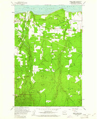 1961 Morse Creek1961 Print · USGSClallam County’s rugged coastline and timbered interior are captured here in the early sixties, showing the reach of the Milwaukee Road. Genealogists and local historians can trace the Cameron Homestead, Fairview Sch, and the Port Angeles Dam.4 unique versions available
 - 1961 Map of Port Angeles, 1962 Print
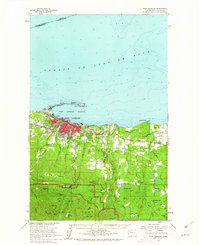 1961 Port Angeles1962 Print · USGSPort Angeles and the Olympic coastline are captured here in the early sixties, showing the city's harbor-driven industry and the nearby wilderness. Researchers can trace family ranchlands like Hambly Ranch, find local landmarks like Fairview Sch, or locate the Cameron Homestead.3 unique versions available
 - 1962 Map of Seattle
 1962 Seattle1962 Print · USGSThe Puget Sound region and Olympic Peninsula are shown at a peak of mid-century growth. Genealogists and historians can trace rail lines like the Pacific Coast RR or locate landmarks such as Fort Lawton and the Bothell Power Station.
 - 1963 Map of Copalis Beach
 1963 Copalis Beach1963 Print · USGSThe Washington coast in the early sixties reveals a landscape of massive timber reserves, indigenous lands, and quiet seaside villages. Genealogists and historians can trace the foundations of coastal life through sites like Lone Fir Cemetery, the Dismantled RR, and the historic oyster beds of Oysterville.
 - 1963 Map of Cape Flattery
 1963 Cape Flattery1963 Print · USGSThe Pacific Northwest coast and the entrance to the Puget Sound are captured in detail during the early 1960s. Researchers can trace remote coastal settlements and tribal lands including the Makah Indian Reserve, Port Renfrew, and the timber town of Sekiu.
End of results
Showing maps 1-7 of 7
Top cities of Clallam County
- Port Angeles historical maps
- Sequim historical maps
- Forks historical maps
- Neah Bay historical maps
- Clallam Bay historical maps
- Blyn historical maps
See more
Frequently asked questions
- What are the different types of historical maps available for Clallam County?
- What is the oldest map of Clallam County?
- Where can I purchase historical maps of Clallam County for my home or office?
- Where can I download high-res historical maps of Clallam County?
- Are there historical topographic maps available for Clallam County?
- Is there historical aerial imagery available for Clallam County?
- Where are historical maps of Clallam County sourced from?