1950s Maps of Clallam County, Washington
Explore 39 historic maps of Clallam County from the 1950s. These maps offer a rare glimpse into what life looked like during the 1950s — showing old roads, neighborhoods, homes, and landmarks that have changed or disappeared over time.
Whether you're researching your family's past, planning a metal detecting trip, or studying how Clallam County's landscape evolved across the 1950s, these high-resolution maps are a powerful tool for exploring the history of this region.
- Focus on a specific era: All maps on this page are from the 1950s, giving you a focused view of this time period.
- See what’s changed: Compare century-old streets, trails, and buildings to today's modern landscape using overlays and satellite layers.
- Research with precision: Use these maps for genealogy, historical research, land use analysis, or educational projects.
- View, download, or print: Maps are fully viewable online in high resolution, and can be downloaded or printed for your own records.
Start exploring Clallam County's history through authentic maps from the 1950s. This is your window into the past.
Clallam County, WA maps
(39)- 1950 Map of Elwha, 1955 Print
 1950 Elwha1955 Print · USGSThe Olympic Peninsula wilderness comes to life in this mid-century survey of the Elwha River corridor. Researchers can trace the original reservoir footprints of Lake Aldwell and find historic sites like Waumilla Lodge and the Dry Creek Sch.5 unique versions available
 - 1950 Map of Ediz Hook, 1955 Print
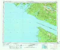
 1950 Ediz Hook1955 Print · USGSPort Angeles and its distinctive sand spit are captured during the early 1950s, showing a busy maritime and military landscape. Researchers can trace the industrial waterfront and naval presence via the U S Coast Guard Station, the Log Storage Area, and the Chicago Milwaukee St Paul and Pacific railroad.
 - 1950 Map of Hurricane Hill, 1955 Print
 1950 Hurricane Hill1955 Print · USGSThe wilderness of Clallam County is captured in the mid-century as early ranching and park infrastructure met the high peaks. Trace the primitive trail system and historic sites like Michaels Ranch, Whiskey Bend, and the Hurricane Hill Lookout.5 unique versions available
 - 1950 Map of Mount Muller, 1955 Print
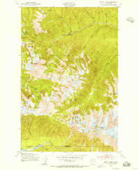
 1950 Mount Muller1955 Print · USGSThe Olympic Peninsula in the early fifties reveals a landscape of deep timber and early mountain roads before modern development. Trace the routes of the Port Angeles and Western Road and Aurora Trail past Fairholm and the western shores of Lake Crescent.4 unique versions available
 - 1950 Map of Lake Sutherland, 1955 Print
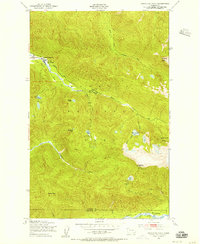
 1950 Lake Sutherland1955 Print · USGSClallam County’s rugged interior is captured here in the 1950s, showing the settlement at Lake Sutherland before modern expansion. Trace the historic route of the Chicago Milwaukee St Paul and Pacific railroad or locate old lakeside landings at Maple Grove and Snug Harbor.3 unique versions available
 - 1950 Map of Twin Rivers, 1955 Print
 1950 Twin Rivers1955 Print · USGSThe northern coast of the Olympic Peninsula is captured here in the mid-1950s, where the forest meets the sea. Researchers can trace early transport routes like the Port Angeles Neah Bay State Highway and the drainage basins of the West Twin River and East Twin River.4 unique versions available
 - 1950 Map of Angeles Point, 1955 Print
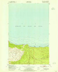
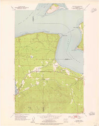
 1950 Angeles Point1955 Print · USGSThe Clallam County coast comes into focus during the early fifties, showing the busy maritime and rail activity at the mouth of the Elwha River. Genealogists and researchers can trace the rail lines through Elwha Station or locate the Ocean View Cem near the Clallam County Airport.2 unique versions available
 - 1950 Map of Joyce, 1955 Print
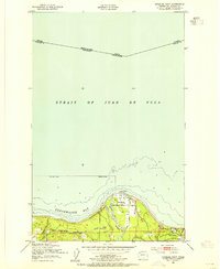
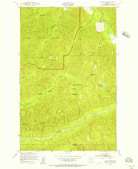
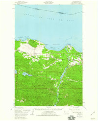
 1950 Joyce1955 Print · USGSThe northern coast of the Olympic Peninsula is captured here in the early 1950s, showing the intersection of military defense and timber-country rail lines. Genealogists and historians can trace the Milwaukee Road through the community of Joyce and locate the Crescent Sch and Camp Hayden.
 - 1950 Map of Port Angeles, 1955 Print
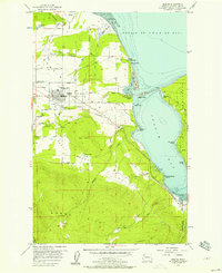
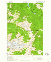
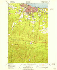 1950 Port Angeles1955 Print · USGSPort Angeles was a bustling maritime and rail hub in the fifties, nestled between the harbor and the high peaks. Trace the old rail lines of the Chicago Milwaukee St Paul and Pacific or locate the Heart of the Hills Ranger Station and Mt Angeles Cem.
 - 1950 Map of Disque, 1955 Print
 1950 Disque1955 Print · USGSThe northern coast of the Olympic Peninsula is captured here in the mid-century, showing a landscape defined by timber and transit. Researchers can trace the path of the Chicago Milwaukee St Paul and Pacific rail line near Disque and Gettysburg Ranch.3 unique versions available
 - 1950 Map of Lake Crescent, 1955 Print
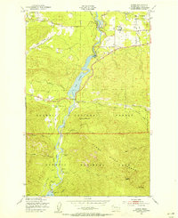
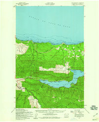
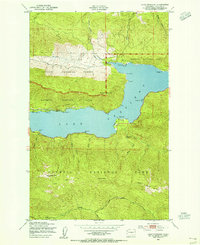 1950 Lake Crescent1955 Print · USGSThe northern Olympic Peninsula comes to life in this mid-century survey, showing the deep waters of Lake Crescent before the full modernization of the regional corridor. Trace the path of the Port Angeles and Western railroad and find lakeside landmarks like Piedmont, Ovington, and the Ranger Station.3 unique versions available
 - 1950 Map of Slide Peak, 1956 Print
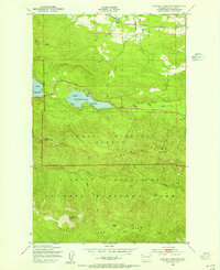
 1950 Slide Peak1956 Print · USGSClallam and Jefferson counties are captured here in the mid-twentieth century, showcasing the deep wilderness of the Olympic Peninsula. Researchers can trace historic backcountry waypoints like Twentyone mile Shelter and summits such as Misery Peak.4 unique versions available
 - 1950 Map of Bogachiel Peak, 1956 Print
 1950 Bogachiel Peak1956 Print · USGSThe high Olympic wilderness comes into focus in the mid-twentieth century as a network of backcountry trails and ranger outposts. You can trace early park infrastructure from the Sol Duc Hot Springs to remote points like the Deer Lake Shelter and Bogachiel Peak.4 unique versions available
 - 1950 Map of Mount Carrie, 1956 Print
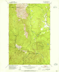
 1950 Mount Carrie1956 Print · USGSOlympic National Park in the early fifties reveals a remote wilderness of high ridges and alpine basins before modern trail expansions. Hikers and historians can trace the early shelter system at Boulder Lake and Olympic Hot Springs.4 unique versions available
 - 1950 Map of Lake Crescent, 1960 Print
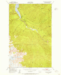
 1950 Lake Crescent1960 Print · USGSClallam County at mid-century reveals a landscape of deep timber and glacial lakes during the height of the Olympic Peninsula's logging era. Trace the path of the Old Railroad Grade and locate old lakeside landings at Fairholm, Piedmont, and Ovington.3 unique versions available
 - 1950 Map of Joyce, 1960 Print
 1950 Joyce1960 Print · USGSCoastal Clallam County at mid-century reveals a landscape of working timberlands and emerging mountain parkland. Researchers can trace the Old Piedmont Railroad Grade or locate early settlements like Ramapo, Maple Grove, and Snug Harbor.2 unique versions available
 - 1951 Map of Copalis Beach
 1951 Copalis Beach1951 Print · USGSThe Olympic Peninsula's rugged coast and tribal lands are meticulously detailed in the early 1950s. Genealogists and historians can trace the foundations of coastal communities from Taholah to La Push or locate early markers like the James Island Lighthouse.
 - 1953 Map of Mt. Walker, 1955 Print
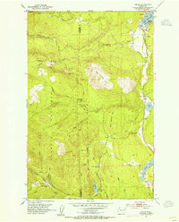
 1953 Mt. Walker1955 Print · USGSJefferson County's eastern Olympic slope is captured here in the early fifties, where the town of Quilcene meets the high timber. Trace mid-century forest infrastructure and landmarks like the U S Fish Hatchery, Rainbow Camp Guard Sta, and Mt Walker.4 unique versions available
 - 1953 Map of Uncas, 1955 Print
 1953 Uncas1955 Print · USGSJefferson County’s coastal forests and timber-focused rail lines are captured here in the early fifties. Local historians can trace the old Olympic P & P RR through the settlements of Uncas and Leland, or locate the Uncas Sch and Snow Creek Guard Sta.4 unique versions available
 - 1953 Map of Gardiner, 1955 Print
 1953 Gardiner1955 Print · USGSThe northern Olympic Peninsula in the early fifties shows a landscape of coastal settlements and timber-era infrastructure. Researchers can trace the Chicago Milwaukee St Paul and Pacific rail line and locate landmarks like the Cem near Blyn and Diamond Pt.5 unique versions available
 - 1953 Map of Cape Flattery, 1968 Print
 1953 Cape Flattery1968 Print · USGSThe maritime border between Washington and British Columbia comes into sharp focus during the mid-century, detailing the remote coastal reaches of both nations. Researchers can trace the layout of the Makah Indian Res and fishing outposts like Sekiu and Port Renfrew.2 unique versions available
 - 1956 Map of Sequim, 1957 Print
 1956 Sequim1957 Print · USGSThe Olympic Peninsula shoreline meets the agricultural Dungeness Valley in the mid-1950s. Genealogists and local historians can trace family-named sites like Beck Ranch and Grennans Hill, or locate the historic Port Williams (Site) and Jamestown Cemetery.5 unique versions available
 - 1956 Map of Carlsborg, 1958 Print
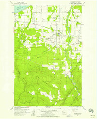 1956 Carlsborg1958 Print · USGSClallam County’s Dungeness Valley in the mid-fifties shows a landscape of timber mills and rural homesteads at the foot of the Olympic Mountains. Genealogists and historians can trace family road names near Agnew, locate the McCleay Sch (Aban'd), or study the path of the Milwaukee Road.4 unique versions available
 - 1956 Map of Morse Creek, 1958 Print
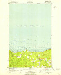
 1956 Morse Creek1958 Print · USGSThe Clallam County coast and the foothills of the Olympic Mountains are captured here in the mid-fifties as rural ranching and timber communities flourished. Researchers can trace family history through the Cameron Homestead, locate the old Fairview School, or find vanished landmarks like the Drive-in Theater.
 - 1956 Map of Mount Olympus, 1960 Print
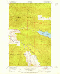
 1956 Mount Olympus1960 Print · USGSThe high Olympic wilderness during the mid-fifties reveals a landscape of massive glaciers and remote pioneer outposts. Trace the early trails and shelters of the high country, from Olympic Hot Springs and Humes Ranch to the ice of Mount Olympus.4 unique versions available
Showing maps 1-25 of 39
Top cities of Clallam County
- Port Angeles historical maps
- Sequim historical maps
- Forks historical maps
- Neah Bay historical maps
- Clallam Bay historical maps
- Blyn historical maps
See more
Frequently asked questions
- What are the different types of historical maps available for Clallam County?
- What is the oldest map of Clallam County?
- Where can I purchase historical maps of Clallam County for my home or office?
- Where can I download high-res historical maps of Clallam County?
- Are there historical topographic maps available for Clallam County?
- Is there historical aerial imagery available for Clallam County?
- Where are historical maps of Clallam County sourced from?