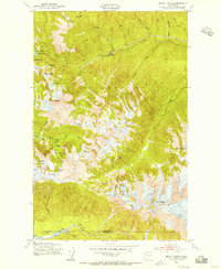
1950 Map of Mount Carrie
USGS Topo · Published 1956About this map
Olympic Hot Springs and the surrounding peaks of the Bailey Range characterize this mid-century survey of the high Olympic interior. The landscape is defined by the headwaters of the Soleduck River and the Hoh River, connected by a network of wilderness routes including the Soleduck Trail and the prominent High Divide. The 1950 field check documents a series of backcountry refuges crucial for early park visitors, such as Boulder Lake Shelter, Sevenmile Shelter, and Heart Lake Shelter. Alpine features like Seven Lakes Basin and Mount Carrie dominate the central topography, while the boundary between Clallam Co and Jefferson Co runs across the southern slopes. This map records the established trail system and landmark falls, including Soleduck Falls, during a period of increasing recreational access to Olympic National Park.
Find a feature on this map
48 named features on this map. Tap any name to fly to it.
Don’t see what you’re looking for? This feature index may not catch every label — zoom into the map to look around manually.
Map Details
Editions of this 1950 Mount Carrie Map
4 editions found
Other maps of this area

1918 · Lake Crescent
USGS Topo · 1:62,500

1919 · Port Crescent
USGS Topo · 1:62,500

1922 · Lake Crescent
USGS Topo · 1:62,500

1935 · Mount Olympus
USGS Topo · 1:62,500

1939 · Mount Tom
USGS Topo · 1:62,500

1942 · Mount Olympus
USGS Topo · 1:62,500

1950 · Elwha
USGS Topo · 1:24,000

1950 · Hurricane Hill
USGS Topo · 1:24,000

1950 · Lake Sutherland
USGS Topo · 1:24,000

1950 · Lake Crescent
USGS Topo · 1:24,000