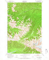
1950 Map of Mount Carrie
USGS Topo · Published 1966About this map
Olympic Hot Springs and its neighboring Campground serve as a central landmark in this mid-century survey of the high Olympics. The map details a landscape defined by dramatic elevation changes, from the depths of Deadmans Gulch to the towering peaks of the Bailey Range and Mount Carrie. A network of backcountry infrastructure is visible throughout the Olympic National Park boundary, including the Boulder Lake Shelter, Soleduck Shelter, and Heart Lake Shelter. These structures, alongside the Happy Lake Trail and Soleduck Trail, illustrate the established recreational use of the high country by 1950. The survey also documents the hydrology of the Seven Lakes Basin, showing the distribution of alpine waters such as Heart Lake, Haigs Lake, and Lake No 8 nestled against the High Divide.
Find a feature on this map
37 named features on this map. Tap any name to fly to it.
Don’t see what you’re looking for? This feature index may not catch every label — zoom into the map to look around manually.
Map Details
Editions of this 1950 Mount Carrie Map
4 editions found
Other maps of this area

1918 · Lake Crescent
USGS Topo · 1:62,500

1919 · Port Crescent
USGS Topo · 1:62,500

1922 · Lake Crescent
USGS Topo · 1:62,500

1935 · Mount Olympus
USGS Topo · 1:62,500

1939 · Mount Tom
USGS Topo · 1:62,500

1942 · Mount Olympus
USGS Topo · 1:62,500

1950 · Elwha
USGS Topo · 1:24,000

1950 · Hurricane Hill
USGS Topo · 1:24,000

1950 · Lake Sutherland
USGS Topo · 1:24,000

1950 · Lake Crescent
USGS Topo · 1:24,000