1990s Maps of Clallam County, Washington
Explore 27 historic maps of Clallam County from the 1990s. These maps offer a rare glimpse into what life looked like during the 1990s — showing old roads, neighborhoods, homes, and landmarks that have changed or disappeared over time.
Whether you're researching your family's past, planning a metal detecting trip, or studying how Clallam County's landscape evolved across the 1990s, these high-resolution maps are a powerful tool for exploring the history of this region.
- Focus on a specific era: All maps on this page are from the 1990s, giving you a focused view of this time period.
- See what’s changed: Compare century-old streets, trails, and buildings to today's modern landscape using overlays and satellite layers.
- Research with precision: Use these maps for genealogy, historical research, land use analysis, or educational projects.
- View, download, or print: Maps are fully viewable online in high resolution, and can be downloaded or printed for your own records.
Start exploring Clallam County's history through authentic maps from the 1990s. This is your window into the past.
Clallam County, WA maps
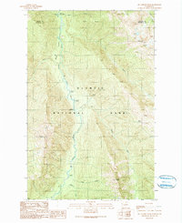
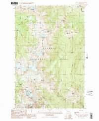
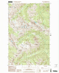
(27)- 1990 Map of Tyler Peak
 1990 Tyler Peak1990 Print · USGSThe Olympic Peninsula backcountry comes into focus in the 1990s as it was managed for both recreation and preservation. Researchers can trace historic access routes and wilderness camps like Three Forks Shelter, Slide Camp, and Gray Wolf Camp.
 - 1990 Map of Mc Cartney Peak
 1990 Mc Cartney Peak1990 Print · USGSOlympic National Park in the 1990s was a landscape of deep river valleys and high glacial peaks. Researchers and hikers can trace the remote network of backcountry outposts including Hayes River Ranger Station and Camp Wilder.
 - 1990 Map of Mount Zion
 1990 Mount Zion1990 Print · USGSThe Olympic Peninsula in the early nineties features a vast network of backcountry trails and forest roads. Trace the mountain paths from Bon Jon Pass to Mount Zion, or locate historic sites like Gold Creek Shelter and East Crossing Campground.
 - 1990 Map of Mount Deception
 1990 Mount Deception1990 Print · USGSThe Olympic Peninsula wilderness comes alive in this 1990 survey of the high-altitude divide between the National Park and Forest. Hikers and researchers can trace the old routes to Camp Handy, Boulder Shelter, and over Marmot Pass.
 - 1990 Map of Wellesley Peak
 1990 Wellesley Peak1990 Print · USGSThe high alpine country of the Olympic Mountains is captured here just before the 1990s, showing the complex glacial systems of the interior range. Hikers and researchers can trace the old routes through Grand Pass, locate remote sites like Bear Camp, and study the extent of the Cameron Glaciers.
 - 1990 Map of Mount Townsend
 1990 Mount Townsend1990 Print · USGSJefferson County’s high Olympic backcountry is captured here during the late twentieth century. Hikers and historians can trace the Pack Trail routes connecting remote landmarks like Tenmile Shelter, Silver Lake, and the summit of Mount Townsend.
 - 1990 Map of Indian Pass
 1990 Indian Pass1990 Print · USGSThe Clallam County wilderness in the 1990s is captured here, showing the convergence of forest and park lands. Researchers can trace the path of the Bogachiel River and locate remote landmarks like the Bogachiel Ranger Station and Indian Pass.
 - 1990 Map of Mount Angeles
 1990 Mount Angeles1990 Print · USGSHigh alpine country and wilderness trails of the Olympic Peninsula are captured in this late-century survey. Backcountry researchers can trace the reaches of the Elwha River and find remote sites like Marys Falls Camp and P J Lake.2 unique versions available
 - 1990 Map of Hunger Mountain
 1990 Hunger Mountain1990 Print · USGSThe Olympic Peninsula wilderness comes into focus in 1990, showing the remote intersection of Clallam and Jefferson counties. Trace the paths of the Bogachiel River and find the location of the Flapjack (Site) and Fifteenmile Shelter.
 - 1990 Map of Mount Queets
 1990 Mount Queets1990 Print · USGSOlympic National Park's high wilderness is documented here as it appeared in the late twentieth century, centered on the glacial headwaters of the Olympic Peninsula. Trace the remote routes through Dodwell-Rixon Pass, locate the Dodger Point Lookout, and study the massive Queets Glacier.2 unique versions available
 - 1990 Map of Maiden Peak
 1990 Maiden Peak1990 Print · USGSOlympic National Park's high ridges and alpine basins are captured in the late twentieth century, showing the land just as modern conservation boundaries were being firmed up. Hikers and researchers can trace trails to Maiden Peak, Moose Lake, and Deer Park Campground.2 unique versions available
 - 1992 Map of Seattle, 1993 Print
 1992 Seattle1993 Print · USGSThe Seattle metropolitan area and Puget Sound are shown here in the early nineties during a period of rapid suburban and technological growth. Researchers can trace the development of Mercer Island, locate the Bangor Naval Submarine Base, and study the industrial layout of Boeing Field.2 unique versions available
 - 1993 Map of Port Townsend
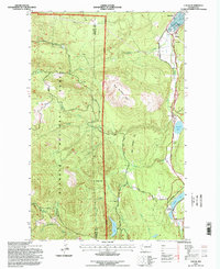
 1993 Port Townsend1993 Print · USGSThe Puget Sound and Whidbey Island are captured in the early nineties, showing a landscape defined by naval aviation and maritime trade. Genealogists and local historians can trace the development of Oak Harbor and Coupeville or locate family sites near the Arlington Municipal Cemetery and Ault Field.
 - 1995 Map of Snider Peak, 1997 Print
 1995 Snider Peak1997 Print · USGSThe Sol Duc Valley and the Olympic National Forest are shown here during the mid-1990s, highlighting the area's timber and management infrastructure. Researchers can trace the Old Railroad Grade along the Sol Duc River and locate the Snider Workcenter or the Lookout Klasha-Niantum.
 - 1995 Map of Mount Walker, 1997 Print
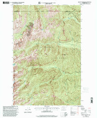
 1995 Mount Walker1997 Print · USGSThe Olympic Peninsula's timber and water infrastructure are well-documented in this mid-nineties survey of the Quilcene area. Researchers can trace the water systems from Lords Lake down to the US Fish Hatchery, while identifying local landmarks like the Quilcene Cemetery and Walker Pass.
 - 1995 Map of Slide Peak, 1997 Print
 1995 Slide Peak1997 Print · USGSThe wilderness of the Olympic Peninsula is captured here in the mid-1990s as the park and forest boundaries meet. Trace the routes of backcountry travelers via the Twentyone Mile Shelter and Hyak Shelter, or locate natural landmarks like Misery Peak and Ring Lake.
 - 1995 Map of Mount Zion, 1997 Print
 1995 Mount Zion1997 Print · USGSThe Olympic Peninsula backcountry comes into focus in the mid-1990s, showcasing the rugged intersection of the Olympic National Forest and the Buckhorn Wilderness. Researchers can trace old forest routes and shelters like Gold Creek Shelter or locate landmarks such as Mount Zion and Schmith Knob.
 - 1995 Map of Hunger Mountain, 1997 Print
 1995 Hunger Mountain1997 Print · USGSThe Olympic Peninsula wilderness in the mid-1990s is captured here, showing the intersection of managed timberlands and protected park territory. Hikers and historians can trace the National Forest National Park Boundary along Rugged Ridge or locate the Hyak Shelter.
 - 1995 Map of Tyler Peak, 1997 Print
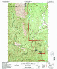
 1995 Tyler Peak1997 Print · USGSClallam County’s high Olympic wilderness is captured here in the mid-nineties during a period of active Forest Service management. Trace backcountry routes like the Slab Camp Trail to find remote landmarks such as Three Forks Shelter and Gray Wolf Ridge.
 - 1995 Map of Mount Muller, 1997 Print
 1995 Mount Muller1997 Print · USGSThe western shores of Lake Crescent and the winding Sol Duc River define this corner of the Olympic Peninsula in the 1990s. Trace the path of the Old Railroad Grade and the small settlement at Fairholm along the Olympic Highway.
 - 1995 Map of Uncas, 1998 Print
 1995 Uncas1998 Print · USGSJefferson County's rugged peninsula terrain is documented in the mid-nineties, showing the intersection of mountain timberlands and coastal settlements. Genealogists and locals can trace the Uncas Sch and rural outposts like Maynard, Uncas, and Leland.
 - 1999 Map of Lake Pleasant, 2001 Print
 1999 Lake Pleasant2001 Print · USGSThe Lake Pleasant area of the Olympic Peninsula shows a landscape of timber-covered hills and vital river valleys in the late 1990s. Researchers can trace the footprint of Sappho, locate the Sol Duc Salmon Hatchery, and explore the limits of Maxfield Prairie.
 - 1999 Map of Mount Townsend, 2001 Print
 1999 Mount Townsend2001 Print · USGSThe eastern Olympic Peninsula highlands are captured here in the late nineties, showcasing the intersection of the Olympic National Forest and Buckhorn Wilderness. Outdoorsmen and researchers can trace trails to remote shelters like Tenmile Shelter and Camp Windy or locate summits like Mount Townsend.
 - 1999 Map of Mount Angeles, 2003 Print
 1999 Mount Angeles2003 Print · USGSOlympic National Park in the late nineties is documented here during a period of established wilderness management and trail development. Hikers and historians can trace routes to Marys Falls Camp, locate PJ Lake, or study the heights of Mount Angeles.
 - 1999 Map of Wellesley Peak, 2003 Print
 1999 Wellesley Peak2003 Print · USGSThe high Olympic wilderness in the late nineties is documented here, showing a landscape defined by glacial peaks and remote river headwaters. Researchers can trace historic backcountry sites like Bear Camp and Camp Marion alongside landmarks such as Wellesley Peak and the Cameron Glaciers.
Showing maps 1-25 of 27
Top cities of Clallam County
- Port Angeles historical maps
- Sequim historical maps
- Forks historical maps
- Neah Bay historical maps
- Clallam Bay historical maps
- Blyn historical maps
See more
Frequently asked questions
- What are the different types of historical maps available for Clallam County?
- What is the oldest map of Clallam County?
- Where can I purchase historical maps of Clallam County for my home or office?
- Where can I download high-res historical maps of Clallam County?
- Are there historical topographic maps available for Clallam County?
- Is there historical aerial imagery available for Clallam County?
- Where are historical maps of Clallam County sourced from?