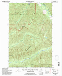
1995 Map of Slide Peak
USGS Topo · Published 1997About this map
Sol Duc River and its accompanying Hot Springs Road mark the northern edge of this remote Olympic Peninsula landscape, where the boundary between Olympic National Forest and Olympic National Park divides the high ridges. Deep within this wilderness, the Bogachiel River system dominates the drainage patterns, receiving water from the North Fork Bogachiel River and South Fork Bogachiel River. The map records the location of vital backcountry infrastructure, specifically the Twentyone Mile Shelter along a designated trail and the Hyak Shelter further west. These structures signify the era's reliance on fixed points for safety in a region defined by steep terrain, including peaks like Misery Peak, Slide Peak, and Sugarloaf Mountain. Small alpine water bodies such as Ring Lake and Blackwood Lake dot the higher elevations between the river basins.
Find a feature on this map
28 named features on this map. Tap any name to fly to it.
Don’t see what you’re looking for? This feature index may not catch every label — zoom into the map to look around manually.
Map Details
Editions of this 1995 Slide Peak Map
This is the sole edition of this map. No revisions or reprints were ever made.
Other maps of this area

1918 · Lake Crescent
USGS Topo · 1:62,500

1922 · Pysht
USGS Topo · 1:62,500

1922 · Lake Crescent
USGS Topo · 1:62,500

1939 · Mount Tom
USGS Topo · 1:62,500

1942 · Pysht
USGS Topo · 1:62,500

1943 · Spruce Mountain
USGS Topo · 1:62,500

1943 · Copalis Beach
USGS Topo · 1:250,000

1950 · Mount Muller
USGS Topo · 1:24,000

1950 · Lake Crescent
USGS Topo · 1:24,000

1950 · Slide Peak
USGS Topo · 1:24,000