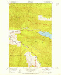
1950 Map of Mount Muller
USGS Topo · Published 1955About this map
Lake Crescent dominates the eastern boundary of this mid-century survey, its shoreline marked by landmarks like Thompson Pt and Meldrim Pt. The small settlement of Fairholm serves as a gateway to the steep, forested interior where Mount Muller towers over the surrounding landscape. The drainage of the Soleduck River and its forks, including the North Fork and South Fork, carves through the terrain of Olympic National Park and Olympic National Forest. Transportation routes of the era are clearly defined, featuring the Olympic Highway and the Port Angeles and Western Road, alongside backcountry routes such as the Aurora Trail and the Soleduck Trail that provide access to the high-elevation Eagle Lakes.
Find a feature on this map
26 named features on this map. Tap any name to fly to it.
Don’t see what you’re looking for? This feature index may not catch every label — zoom into the map to look around manually.
Map Details
Editions of this 1950 Mount Muller Map
4 editions found
Historical Maps of Clallam County Through Time
307 maps found

1918 Lake Crescent
Clallam County, WA

1919 Port Crescent
Clallam County, WA

1922 Lake Crescent
Clallam County, WA

1922 Pysht
Clallam County, WA

1935 Clallam
Clallam County, WA

1935 Lake Pleasant
Clallam County, WA

1935 Ozette Lake
Clallam County, WA

1938 Cape Flattery
Clallam County, WA

1938 Dungeness
Clallam County, WA

1939 Dungeness
Clallam County, WA

1942 Clallam
Clallam County, WA

1942 Lake Pleasant
Clallam County, WA

1942 Ozette Lake
Clallam County, WA

1942 Pysht
Clallam County, WA

1944 Mt. Angeles
Clallam County, WA

1946 Mt. Angeles
Clallam County, WA

1946 Tyler Peak
Clallam County, WA

1948 Tyler Peak
Clallam County, WA

1950 Angeles Point
Clallam County, WA

1950 Bogachiel Peak
Clallam County, WA

1950 Disque
Clallam County, WA

1950 Ediz Hook
Clallam County, WA

1950 Elwha
Clallam County, WA

1950 Hurricane Hill
Clallam County, WA

1950 Joyce
Clallam County, WA

1950 Joyce
Clallam County, WA

1950 Lake Crescent
Clallam County, WA

1950 Lake Crescent
Clallam County, WA

1950 Lake Sutherland
Clallam County, WA

1950 Mount Carrie
Clallam County, WA

1950 Mount Muller
Clallam County, WA

1950 Slide Peak
Clallam County, WA

1950 Twin Rivers
Clallam County, WA

1953 Cape Flattery
Clallam County, WA

1953 Gardiner
Clallam County, WA

1956 La Push
Clallam County, WA

1956 Morse Creek
Clallam County, WA

1956 Ozette Lake
Clallam County, WA

1957 Cape Flattery
Clallam County, WA

1957 Lake Pleasant
Clallam County, WA

1957 Pysht
Clallam County, WA

1961 Ediz Hook
Clallam County, WA

1961 Morse Creek
Clallam County, WA

1963 Cape Flattery
Clallam County, WA

1981 Reade Hill
Clallam County, WA

1982 La Push
Clallam County, WA

1982 Quillayute Prairie
Clallam County, WA

1984 Allens Bay
Clallam County, WA

1984 Bodelteh Islands
Clallam County, WA

1984 Cape Flattery
Clallam County, WA

1984 Deadmans Hill
Clallam County, WA

1984 Dickey Lake
Clallam County, WA

1984 Ellis Mountain
Clallam County, WA

1984 Gunderson Mtn
Clallam County, WA

1984 Hoko Falls
Clallam County, WA

1984 Lake Pleasant
Clallam County, WA

1984 Makah Bay
Clallam County, WA

1984 Ozette
Clallam County, WA

1984 Pysht
Clallam County, WA

1984 Sekiu River
Clallam County, WA

1984 Slip Point
Clallam County, WA

1984 Snider Peak
Clallam County, WA

1984 Umbrella Creek
Clallam County, WA

1984 Waadah Island
Clallam County, WA

1984 West of Pysht
Clallam County, WA

1986 Cape Flattery
Clallam County, WA

1990 Hunger Mountain
Clallam County, WA

1990 Indian Pass
Clallam County, WA

1990 Maiden Peak
Clallam County, WA

1990 Mount Angeles
Clallam County, WA

1990 Mount Zion
Clallam County, WA

1990 Tyler Peak
Clallam County, WA

1995 Hunger Mountain
Clallam County, WA

1995 Mount Muller
Clallam County, WA

1995 Mount Zion
Clallam County, WA

1995 Slide Peak
Clallam County, WA

1995 Snider Peak
Clallam County, WA

1995 Tyler Peak
Clallam County, WA

1999 Hurricane Hill
Clallam County, WA

1999 Lake Pleasant
Clallam County, WA

1999 Mount Angeles
Clallam County, WA

1999 Mount Carrie
Clallam County, WA

2002 Hunger Mountain
Clallam County, WA

2011 Allens Bay
Clallam County, WA

2011 Angeles Point
Clallam County, WA

2011 Bodelteh Islands
Clallam County, WA

2011 Bogachiel Peak
Clallam County, WA

2011 Cape Flattery
Clallam County, WA

2011 Deadmans Hill
Clallam County, WA

2011 Dickey Lake
Clallam County, WA

2011 Disque
Clallam County, WA

2011 Dungeness
Clallam County, WA

2011 Dungeness OE E
Clallam County, WA

2011 Ediz Hook
Clallam County, WA

2011 Ellis Mountain
Clallam County, WA

2011 Elwha
Clallam County, WA

2011 Gardiner
Clallam County, WA

2011 Gunderson Mountain
Clallam County, WA

2011 Hoko Falls
Clallam County, WA

2011 Hunger Mountain
Clallam County, WA

2011 Hurricane Hill
Clallam County, WA

2011 Indian Pass
Clallam County, WA

2011 Joyce
Clallam County, WA

2011 Lake Crescent
Clallam County, WA

2011 Lake Pleasant
Clallam County, WA

2011 Lake Sutherland
Clallam County, WA

2011 La Push
Clallam County, WA

2011 Maiden Peak
Clallam County, WA

2011 Makah Bay
Clallam County, WA

2011 Morse Creek
Clallam County, WA

2011 Mount Angeles
Clallam County, WA

2011 Mount Carrie
Clallam County, WA

2011 Mount Muller
Clallam County, WA

2011 Mount Zion
Clallam County, WA

2011 Ozette
Clallam County, WA

2011 Pysht
Clallam County, WA

2011 Quillayute Prairie
Clallam County, WA

2011 Reade Hill
Clallam County, WA

2011 Sekiu River
Clallam County, WA

2011 Slide Peak
Clallam County, WA

2011 Slip Point
Clallam County, WA

2011 Snider Peak
Clallam County, WA

2011 Twin Rivers
Clallam County, WA

2011 Tyler Peak
Clallam County, WA

2011 Umbrella Creek
Clallam County, WA

2011 Waadah Island
Clallam County, WA

2011 West of Pysht
Clallam County, WA

2014 Allens Bay
Clallam County, WA

2014 Angeles Point
Clallam County, WA

2014 Bodelteh Islands
Clallam County, WA

2014 Bogachiel Peak
Clallam County, WA

2014 Cape Flattery
Clallam County, WA

2014 Deadmans Hill
Clallam County, WA

2014 Dickey Lake
Clallam County, WA

2014 Disque
Clallam County, WA

2014 Dungeness
Clallam County, WA

2014 Dungeness OE E
Clallam County, WA

2014 Ediz Hook
Clallam County, WA

2014 Ellis Mountain
Clallam County, WA

2014 Elwha
Clallam County, WA

2014 Gardiner
Clallam County, WA

2014 Gunderson Mountain
Clallam County, WA

2014 Hoko Falls
Clallam County, WA

2014 Hunger Mountain
Clallam County, WA

2014 Hurricane Hill
Clallam County, WA

2014 Indian Pass
Clallam County, WA

2014 Joyce
Clallam County, WA

2014 Lake Crescent
Clallam County, WA

2014 Lake Pleasant
Clallam County, WA

2014 Lake Sutherland
Clallam County, WA

2014 La Push
Clallam County, WA

2014 Maiden Peak
Clallam County, WA

2014 Makah Bay
Clallam County, WA

2014 Morse Creek
Clallam County, WA

2014 Mount Angeles
Clallam County, WA

2014 Mount Carrie
Clallam County, WA

2014 Mount Muller
Clallam County, WA

2014 Mount Zion
Clallam County, WA

2014 Ozette
Clallam County, WA

2014 Pysht
Clallam County, WA

2014 Quillayute Prairie
Clallam County, WA

2014 Reade Hill
Clallam County, WA

2014 Sekiu River
Clallam County, WA

2014 Slide Peak
Clallam County, WA

2014 Slip Point
Clallam County, WA

2014 Snider Peak
Clallam County, WA

2014 Strait of Juan de Fuca (All Water)
Clallam County, WA

2014 Twin Rivers
Clallam County, WA

2014 Tyler Peak
Clallam County, WA

2014 Umbrella Creek
Clallam County, WA

2014 Waadah Island
Clallam County, WA

2014 West of Pysht
Clallam County, WA

2017 Allens Bay
Clallam County, WA

2017 Angeles Point
Clallam County, WA

2017 Bodelteh Islands
Clallam County, WA

2017 Bogachiel Peak
Clallam County, WA

2017 Cape Flattery
Clallam County, WA

2017 Deadmans Hill
Clallam County, WA

2017 Dickey Lake
Clallam County, WA

2017 Disque
Clallam County, WA

2017 Dungeness
Clallam County, WA

2017 Dungeness OE E
Clallam County, WA

2017 Ediz Hook
Clallam County, WA

2017 Ellis Mountain
Clallam County, WA

2017 Elwha
Clallam County, WA

2017 Gardiner
Clallam County, WA

2017 Gunderson Mountain
Clallam County, WA

2017 Hoko Falls
Clallam County, WA

2017 Hunger Mountain
Clallam County, WA

2017 Hurricane Hill
Clallam County, WA

2017 Indian Pass
Clallam County, WA

2017 Joyce
Clallam County, WA

2017 Lake Crescent
Clallam County, WA

2017 Lake Pleasant
Clallam County, WA

2017 Lake Sutherland
Clallam County, WA

2017 La Push
Clallam County, WA

2017 Maiden Peak
Clallam County, WA

2017 Makah Bay
Clallam County, WA

2017 Morse Creek
Clallam County, WA

2017 Mount Angeles
Clallam County, WA

2017 Mount Carrie
Clallam County, WA

2017 Mount Muller
Clallam County, WA

2017 Mount Zion
Clallam County, WA

2017 Ozette
Clallam County, WA

2017 Pysht
Clallam County, WA

2017 Quillayute Prairie
Clallam County, WA

2017 Reade Hill
Clallam County, WA

2017 Sekiu River
Clallam County, WA

2017 Slide Peak
Clallam County, WA

2017 Slip Point
Clallam County, WA

2017 Snider Peak
Clallam County, WA

2017 Strait of Juan de Fuca (All Water)
Clallam County, WA

2017 Twin Rivers
Clallam County, WA

2017 Tyler Peak
Clallam County, WA

2017 Umbrella Creek
Clallam County, WA

2017 Waadah Island
Clallam County, WA

2017 West of Pysht
Clallam County, WA

2020 Allens Bay
Clallam County, WA

2020 Angeles Point
Clallam County, WA

2020 Bodelteh Islands
Clallam County, WA

2020 Bogachiel Peak
Clallam County, WA

2020 Cape Flattery
Clallam County, WA

2020 Deadmans Hill
Clallam County, WA

2020 Dickey Lake
Clallam County, WA

2020 Disque
Clallam County, WA

2020 Dungeness
Clallam County, WA

2020 Dungeness OE E
Clallam County, WA

2020 Ediz Hook
Clallam County, WA

2020 Ellis Mountain
Clallam County, WA

2020 Elwha
Clallam County, WA

2020 Gardiner
Clallam County, WA

2020 Gunderson Mountain
Clallam County, WA

2020 Hoko Falls
Clallam County, WA

2020 Hunger Mountain
Clallam County, WA

2020 Hurricane Hill
Clallam County, WA

2020 Indian Pass
Clallam County, WA

2020 Joyce
Clallam County, WA

2020 Lake Crescent
Clallam County, WA

2020 Lake Pleasant
Clallam County, WA

2020 Lake Sutherland
Clallam County, WA

2020 La Push
Clallam County, WA

2020 Maiden Peak
Clallam County, WA

2020 Makah Bay
Clallam County, WA

2020 Morse Creek
Clallam County, WA

2020 Mount Angeles
Clallam County, WA

2020 Mount Carrie
Clallam County, WA

2020 Mount Muller
Clallam County, WA

2020 Mount Zion
Clallam County, WA

2020 Ozette
Clallam County, WA

2020 Pysht
Clallam County, WA

2020 Quillayute Prairie
Clallam County, WA

2020 Reade Hill
Clallam County, WA

2020 Sekiu River
Clallam County, WA

2020 Slide Peak
Clallam County, WA

2020 Slip Point
Clallam County, WA

2020 Snider Peak
Clallam County, WA

2020 Strait of Juan de Fuca (All Water)
Clallam County, WA

2020 Twin Rivers
Clallam County, WA

2020 Tyler Peak
Clallam County, WA

2020 Umbrella Creek
Clallam County, WA

2020 Waadah Island
Clallam County, WA

2020 West of Pysht
Clallam County, WA

2023 Allens Bay
Clallam County, WA

2023 Angeles Point
Clallam County, WA

2023 Bodelteh Islands
Clallam County, WA

2023 Bogachiel Peak
Clallam County, WA

2023 Cape Flattery
Clallam County, WA

2023 Deadmans Hill
Clallam County, WA

2023 Dickey Lake
Clallam County, WA

2023 Disque
Clallam County, WA

2023 Dungeness
Clallam County, WA

2023 Dungeness OE E
Clallam County, WA

2023 Ediz Hook
Clallam County, WA

2023 Ellis Mountain
Clallam County, WA

2023 Elwha
Clallam County, WA

2023 Gardiner
Clallam County, WA

2023 Gunderson Mountain
Clallam County, WA

2023 Hoko Falls
Clallam County, WA

2023 Hunger Mountain
Clallam County, WA

2023 Hurricane Hill
Clallam County, WA

2023 Indian Pass
Clallam County, WA

2023 Joyce
Clallam County, WA

2023 Lake Crescent
Clallam County, WA

2023 Lake Pleasant
Clallam County, WA

2023 Lake Sutherland
Clallam County, WA

2023 La Push
Clallam County, WA

2023 Maiden Peak
Clallam County, WA

2023 Makah Bay
Clallam County, WA

2023 Morse Creek
Clallam County, WA

2023 Mount Angeles
Clallam County, WA

2023 Mount Carrie
Clallam County, WA

2023 Mount Muller
Clallam County, WA

2023 Mount Zion
Clallam County, WA

2023 Ozette
Clallam County, WA

2023 Pysht
Clallam County, WA

2023 Quillayute Prairie
Clallam County, WA

2023 Reade Hill
Clallam County, WA

2023 Sekiu River
Clallam County, WA

2023 Slide Peak
Clallam County, WA

2023 Slip Point
Clallam County, WA

2023 Snider Peak
Clallam County, WA

2023 Strait of Juan de Fuca (All Water)
Clallam County, WA

2023 Twin Rivers
Clallam County, WA

2023 Tyler Peak
Clallam County, WA

2023 Umbrella Creek
Clallam County, WA

2023 Waadah Island
Clallam County, WA

2023 West of Pysht
Clallam County, WA