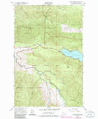
1950 Map of Mount Muller
USGS Topo · Published 1986About this map
Lake Crescent dominates the eastern edge of this landscape, its waters meeting the shore at Fairholm and Thompson Pt. The mid-century topography reflects a transition in transport and land use, where the Old Railroad Grade runs parallel to the Olympic Highway, tracing the northern contours of the mountains. Much of the territory is divided between Olympic National Forest and Olympic National Park, showing the early management of these timber and recreational lands.
Find a feature on this map
24 named features on this map. Tap any name to fly to it.
Don’t see what you’re looking for? This feature index may not catch every label — zoom into the map to look around manually.
Map Details
Editions of this 1950 Mount Muller Map
4 editions found
Other maps of this area

1918 · Lake Crescent
USGS Topo · 1:62,500

1922 · Pysht
USGS Topo · 1:62,500

1922 · Lake Crescent
USGS Topo · 1:62,500

1939 · Mount Tom
USGS Topo · 1:62,500

1942 · Pysht
USGS Topo · 1:62,500

1943 · Spruce Mountain
USGS Topo · 1:62,500

1943 · Copalis Beach
USGS Topo · 1:250,000

1950 · Mount Muller
USGS Topo · 1:24,000

1950 · Twin Rivers
USGS Topo · 1:24,000
1950 · Disque
USGS Topo · 1:24,000