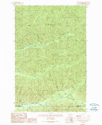
1990 Map of Hunger Mountain
USGS Topo · Published 1990About this map
Olympic National Park and Olympic National Forest converge in this 1990 survey of the Olympic Peninsula. The terrain is defined by a dense network of drainages, including the Bogachiel River and the Calawah River. Notable for its lack of modern infrastructure, the landscape is preserved through a system of trails and landmarks such as the Fifteenmile Shelter and the historic Flapjack (Site). The map details the transition across the Clallam and Jefferson county line, where Hunger Mountain and Rugged Ridge dominate the elevation. This sheet provides a clear view of the wilderness management boundaries as they existed in the late twentieth century, showing the intricate relationship between the protected parklands and the national forest areas.
Find a feature on this map
29 named features on this map. Tap any name to fly to it.
Don’t see what you’re looking for? This feature index may not catch every label — zoom into the map to look around manually.
Map Details
Editions of this 1990 Hunger Mountain Map
This is the sole edition of this map. No revisions or reprints were ever made.
Other maps of this area

1918 · Lake Crescent
USGS Topo · 1:62,500

1922 · Pysht
USGS Topo · 1:62,500

1922 · Lake Crescent
USGS Topo · 1:62,500

1939 · Mount Tom
USGS Topo · 1:62,500

1942 · Pysht
USGS Topo · 1:62,500

1943 · Spruce Mountain
USGS Topo · 1:62,500

1943 · Copalis Beach
USGS Topo · 1:250,000

1950 · Mount Muller
USGS Topo · 1:24,000

1950 · Slide Peak
USGS Topo · 1:24,000
1950 · Lake Crescent
USGS Topo · 1:62,500