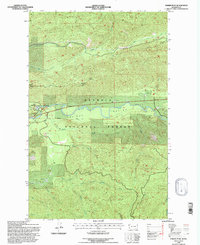
1995 Map of Snider Peak
USGS Topo · Published 1997About this map
The Sol Duc River carves through the heart of the Olympic National Forest, defining the geography of the Sol Duc Valley during the mid-1990s. This survey records a landscape shaped by both natural drainage and forest management, where the Snider Workcenter serves as a primary administrative hub near the foot of Snider Peak. A historical Old Railroad Grade follows the northern bank of the river, tracing the path of earlier timber or transport operations through the valley. High-elevation points like North Point and Bigler Mountain rise above a dense network of tributaries including Deep Creek, Kugel Creek, and Camp Creek. To the south, the terrain shifts toward the headwaters of the North Fork Calawah River, while the Lookout Klasha-Niantum marks a significant vantage point for fire surveillance or forest observation.
Find a feature on this map
30 named features on this map. Tap any name to fly to it.
Don’t see what you’re looking for? This feature index may not catch every label — zoom into the map to look around manually.
Map Details
Editions of this 1995 Snider Peak Map
This is the sole edition of this map. No revisions or reprints were ever made.
Other maps of this area

1918 · Lake Crescent
USGS Topo · 1:62,500

1922 · Pysht
USGS Topo · 1:62,500

1922 · Lake Crescent
USGS Topo · 1:62,500

1939 · Mount Tom
USGS Topo · 1:62,500

1942 · Pysht
USGS Topo · 1:62,500

1943 · Spruce Mountain
USGS Topo · 1:62,500

1943 · Copalis Beach
USGS Topo · 1:250,000

1950 · Mount Muller
USGS Topo · 1:24,000

1950 · Twin Rivers
USGS Topo · 1:24,000

1950 · Slide Peak
USGS Topo · 1:24,000