1940s Maps of Snohomish County, Washington
Explore 10 historic maps of Snohomish County from the 1940s. These maps offer a rare glimpse into what life looked like during the 1940s — showing old roads, neighborhoods, homes, and landmarks that have changed or disappeared over time.
Whether you're researching your family's past, planning a metal detecting trip, or studying how Snohomish County's landscape evolved across the 1940s, these high-resolution maps are a powerful tool for exploring the history of this region.
- Focus on a specific era: All maps on this page are from the 1940s, giving you a focused view of this time period.
- See what’s changed: Compare century-old streets, trails, and buildings to today's modern landscape using overlays and satellite layers.
- Research with precision: Use these maps for genealogy, historical research, land use analysis, or educational projects.
- View, download, or print: Maps are fully viewable online in high resolution, and can be downloaded or printed for your own records.
Start exploring Snohomish County's history through authentic maps from the 1940s. This is your window into the past.
Snohomish County, WA maps
(10)- 1940 Map of Mt Vernon, 1957 Print
 1940 Mt Vernon1957 Print · USGSThe Skagit River delta and its thriving rail-and-river towns are captured here just before the mid-century. Genealogists can trace family roots through numerous country schools like Harmony Sch and landmarks like the Milltown Ch or the timber-hauling Logging Railroad.2 unique versions available
 - 1941 Map of Marysville, 1959 Print
 1941 Marysville1959 Print · USGSSnohomish County is captured here just before the mid-century, showing the vital rail-and-river networks connecting the Puget Sound to the Cascades. Trace family roots and vanished landmarks through early rural sites like Shoultes Sch, the Tulalip Indian Reservation, and Sisco Heights.
 - 1942 Map of Edmonds, 1944 Print
 1942 Edmonds1944 Print · USGSCoastal Snohomish County and Whidbey Island are captured in the early 1940s during a period of maritime and rail expansion. Researchers can trace historic ferry lines, the Great Northern railroad, and local landmarks like Alderwood Manor and Firlands Sanitarium.
 - 1943 Map of Marysville
 1943 Marysville1943 Print · USGSSnohomish County thrived as a railroad and river hub during the early 1940s. Genealogists and local historians can trace rural schoolhouse locations like Shoultes Sch and early transit nodes such as Lakewood English Sta and Stimson Crossing.2 unique versions available
 - 1943 Map of Mt Vernon
 1943 Mt Vernon1943 Print · USGSSkagit County during the early years of the war reveals a complex network of river deltas and rail-dependent settlements. Researchers can trace the heritage of rural communities through labels for Skagit City, the Ridgeway Sch, and the Great Northern railroad.2 unique versions available
 - 1943 Map of Stanwood
 1943 Stanwood1943 Print · USGSThe Puget Sound shoreline comes alive in the early 1940s, showing the intricate waterways and settlements surrounding the Stillaguamish River delta. Genealogists and local historians can trace schoolhouse locations like School No 203 or coastal communities such as Langley and Mabana.2 unique versions available
 - 1944 Map of Clear Lake
 1944 Clear Lake1944 Print · USGSSkagit County in the early 1940s was a hub of timber production and rail transport. Genealogists and historians can trace the Northern Pacific RR through settlements like Montborne and find rural landmarks such as Electron Sch and the high Lake Cavanaugh.
 - 1944 Map of Everett
 1944 Everett1944 Print · USGSMid-century Snohomish County shows a landscape of industrial riverfronts and rural schoolhouses during the Second World War. Genealogists can trace family names at Cypress Lawn Cem, locate the CCC Camp, or find old school sites like Forbes Sch.
 - 1944 Map of Holden, 1955 Print
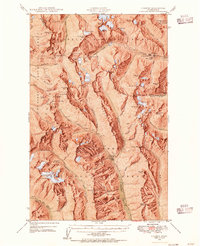 1944 Holden1955 Print · USGSThe northern Cascades of the 1940s come into focus through this survey of the high alpine region between Chelan and Snohomish counties. Researchers can trace the legacy of remote mining at the Holden Mine and find the site of the old Trinity settlement.7 unique versions available
 - 1949 Map of Holden
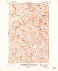 1949 Holden1949 Print · USGSThe high Cascades of Chelan County are documented here during the post-war era of active mountain mining and alpine exploration. Researchers can trace the industrial footprint of the Holden Mine and Glacier Peak Mines alongside high-country camps like McKenzie Camp.3 unique versions available
End of results
Showing maps 1-10 of 10
Top cities of Snohomish County
- Everett historical maps
- Marysville historical maps
- Edmonds historical maps
- Lynnwood historical maps
- Lake Stevens historical maps
- Silver Firs historical maps
See more
Frequently asked questions
- What are the different types of historical maps available for Snohomish County?
- What is the oldest map of Snohomish County?
- Where can I purchase historical maps of Snohomish County for my home or office?
- Where can I download high-res historical maps of Snohomish County?
- Are there historical topographic maps available for Snohomish County?
- Is there historical aerial imagery available for Snohomish County?
- Where are historical maps of Snohomish County sourced from?