1990s Maps of Snohomish County, Washington
Explore 19 historic maps of Snohomish County from the 1990s. These maps offer a rare glimpse into what life looked like during the 1990s — showing old roads, neighborhoods, homes, and landmarks that have changed or disappeared over time.
Whether you're researching your family's past, planning a metal detecting trip, or studying how Snohomish County's landscape evolved across the 1990s, these high-resolution maps are a powerful tool for exploring the history of this region.
- Focus on a specific era: All maps on this page are from the 1990s, giving you a focused view of this time period.
- See what’s changed: Compare century-old streets, trails, and buildings to today's modern landscape using overlays and satellite layers.
- Research with precision: Use these maps for genealogy, historical research, land use analysis, or educational projects.
- View, download, or print: Maps are fully viewable online in high resolution, and can be downloaded or printed for your own records.
Start exploring Snohomish County's history through authentic maps from the 1990s. This is your window into the past.
Snohomish County, WA maps
(19)- 1992 Map of Seattle, 1993 Print
 1992 Seattle1993 Print · USGSThe Seattle metropolitan area and Puget Sound are shown here in the early nineties during a period of rapid suburban and technological growth. Researchers can trace the development of Mercer Island, locate the Bangor Naval Submarine Base, and study the industrial layout of Boeing Field.2 unique versions available
 - 1993 Map of Monroe
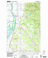
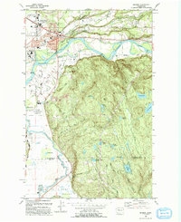 1993 Monroe1993 Print · USGSThe Skykomish and Snoqualmie valleys meet here in the early nineties, showing a region defined by river-borne transit and state institutions. Trace family history at the IOOF Cem, or locate the State Reformatory and the Evergreen State Fairground.
 - 1993 Map of Port Townsend
 1993 Port Townsend1993 Print · USGSThe Puget Sound and Whidbey Island are captured in the early nineties, showing a landscape defined by naval aviation and maritime trade. Genealogists and local historians can trace the development of Oak Harbor and Coupeville or locate family sites near the Arlington Municipal Cemetery and Ault Field.
 - 1993 Map of Sultan
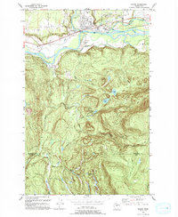 1993 Sultan1993 Print · USGSSultan sits at the confluence of two major rivers in the early nineties, where timber history meets a growing valley community. Trace the remnants of the Old Railroad Grade or locate high-country landmarks like Drunken Charlie Lake and Lake Elsie.
 - 1997 Map of Edmonds West, 2003 Print
 1997 Edmonds West2003 Print · USGSPuget Sound’s busy maritime corridor is captured here in the late nineties, documenting the evolving shoreline from the Kitsap Peninsula to Edmonds. Maritime researchers can trace ferry lanes, locate a Sunken Wreck near Apple Cove Point, and see industrial sites like the oil tanks at Point Wells.
 - 1997 Map of Sultan, 2003 Print
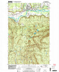 1997 Sultan2003 Print · USGSThe confluence of the Skykomish and Sultan rivers defines this late-century landscape, showing the town of Sultan as it transitioned from a timber hub to a growing residential community. Researchers can trace historic industrial footprints and local landmarks like the Cemetery, the Old Railroad Grade, and Drunken Charlie Lake.
 - 1997 Map of Maxwelton, 2003 Print
 1997 Maxwelton2003 Print · USGSSouthern Whidbey Island in the late nineties shows a landscape of tidal lagoons and established coastal communities. You can trace local landmarks like Sunlight Beach, the wetlands of Deer Lagoon, and the prominent landmarks of Scatchet Head and Possession Point.
 - 1997 Map of Lake Roesiger, 2003 Print
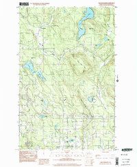 1997 Lake Roesiger2003 Print · USGSSnohomish County in the late nineties is a landscape of lakeside parks and timbered hills. Researchers can trace the development of Lake Roesiger and find old settlements like Forest Glade and Wagner alongside Three Lakes Hill.
 - 1998 Map of Conway, 2003 Print
 1998 Conway2003 Print · USGSThe Skagit River delta and Snohomish County line are captured here in the late 1990s as agriculture and industry meet the foothills. Researchers can trace the intricate network of Steamboat Slough, locate the Conway Sch, or find family sites near Milltown and Freeborn Church.
 - 1998 Map of Stimson Hill, 2003 Print
 1998 Stimson Hill2003 Print · USGSSkagit and Snohomish counties meet along this timbered ridgeline in the late nineties, where the valley floor transitions into the high Cascades. Researchers can trace the rural layout of Cicero and Crane or locate old industrial sites like the Quarry and Borrow Pit.
 - 1998 Map of Utsalady, 2003 Print
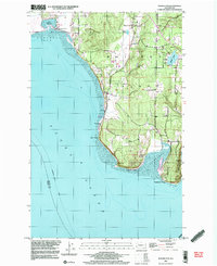
 1998 Utsalady2003 Print · USGSThe Skagit River delta meets the Salish Sea in the late nineties, showing a landscape of fertile islands and tidal flats. Genealogists and historians can trace coastal settlements like Utsalady and Fish Town, or the historic timber site at English Boom near Utsalady Pt.
 - 1999 Map of Lime Mountain, 2002 Print
 1999 Lime Mountain2002 Print · USGSThe high Cascades of Snohomish County are captured here at the close of the twentieth century. Hikers and researchers can trace the Pacific Crest National Scenic Trail past Milk Lake Glacier and the slopes of Kennedy Peak.
 - 1999 Map of Suiattle Pass, 2002 Print
 1999 Suiattle Pass2002 Print · USGSThe High Cascades at the end of the twentieth century appear here as a land of ice and alpine paths where Snohomish and Chelan counties meet. Hikers and historians can trace the Pacific Crest National Scenic Trail through Suiattle Pass or locate the remote Glacier Peak Mines.
 - 1999 Map of Gamma Peak, 2002 Print
 1999 Gamma Peak2002 Print · USGSThe high Cascades of Snohomish County are captured here at the close of the twentieth century, showcasing a wilderness of glaciers and geothermal springs. Hikers and historians can trace the Pacific Crest National Scenic Trail as it passes Image Lake and the remote Gamma Hot Springs.
 - 1999 Map of Glacier Peak West, 2002 Print
 1999 Glacier Peak West2002 Print · USGSThe high Cascades at the end of the twentieth century are preserved here, centered on the glaciated peaks of the Snohomish and Chelan county line. Hikers and historians can trace the Pacific Crest National Scenic Trail past the Mackinaw Shelter and White Chuck Glacier.
 - 1999 Map of Sloan Peak, 2002 Print
 1999 Sloan Peak2002 Print · USGSThe Cascades high country at the close of the century shows a landscape defined by protected wilderness and glacial peaks. Outdoor historians and researchers can trace the alpine terrain around Sloan Peak, Goat Lake, and the upper North Fork Sauk River.
 - 1999 Map of Glacier Peak East, 2002 Print
 1999 Glacier Peak East2002 Print · USGSThe High Cascades at the turn of the millennium reveal a frozen landscape of radiating ice and prominent summits. Researchers can trace the massive ice fields of Honeycomb Glacier and Kennedy Glacier or locate the headwaters of the Suiattle River.
 - 1999 Map of Dome Peak, 2002 Print
 1999 Dome Peak2002 Print · USGSThe North Cascades high country at the close of the twentieth century reveals a landscape defined by ice and altitude. Mountaineers and researchers can trace the margins of the South Cascade Glacier and find remote landmarks like Itswoot Lake and Sinister Peak.
 - 1999 Map of Mount Pugh, 2002 Print
 1999 Mount Pugh2002 Print · USGSThe high Cascades come into sharp focus in the late nineties, centered on the protected wilderness of Snohomish County. Hikers and cartographic researchers can trace the Meadow Mtn Trail past high-elevation landmarks like Circle Peak Lookout and Emerald Lake.
End of results
Showing maps 1-19 of 19
Top cities of Snohomish County
- Everett historical maps
- Marysville historical maps
- Edmonds historical maps
- Lynnwood historical maps
- Lake Stevens historical maps
- Silver Firs historical maps
See more
Frequently asked questions
- What are the different types of historical maps available for Snohomish County?
- What is the oldest map of Snohomish County?
- Where can I purchase historical maps of Snohomish County for my home or office?
- Where can I download high-res historical maps of Snohomish County?
- Are there historical topographic maps available for Snohomish County?
- Is there historical aerial imagery available for Snohomish County?
- Where are historical maps of Snohomish County sourced from?