1970s Maps of Whitman County, Washington
Explore 5 historic maps of Whitman County from the 1970s. These maps offer a rare glimpse into what life looked like during the 1970s — showing old roads, neighborhoods, homes, and landmarks that have changed or disappeared over time.
Whether you're researching your family's past, planning a metal detecting trip, or studying how Whitman County's landscape evolved across the 1970s, these high-resolution maps are a powerful tool for exploring the history of this region.
- Focus on a specific era: All maps on this page are from the 1970s, giving you a focused view of this time period.
- See what’s changed: Compare century-old streets, trails, and buildings to today's modern landscape using overlays and satellite layers.
- Research with precision: Use these maps for genealogy, historical research, land use analysis, or educational projects.
- View, download, or print: Maps are fully viewable online in high resolution, and can be downloaded or printed for your own records.
Start exploring Whitman County's history through authentic maps from the 1970s. This is your window into the past.
Whitman County, WA maps
(5)- 1971 Map of Silcott, 1974 Print
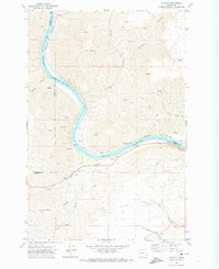 1971 Silcott1974 Print · USGSThe Snake River canyonlands come into focus in the early 1970s, showing the intersection of three Washington counties. Researchers can trace historic river crossings and early settlements like Silcott and Wilma, or locate the Indian Timothy Bridge and local Cem.
 - 1971 Map of Clarkston, 1974 Print
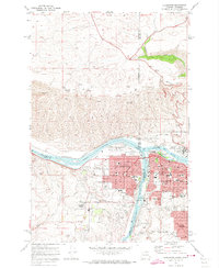 1971 Clarkston1974 Print · USGSThe growing border communities of Clarkston and Lewiston are captured in the early 1970s at the meeting of the Snake and Clearwater Rivers. Genealogists can locate family landmarks like Vineland Cemetery, Stout Ranch, and the North Idaho Childrens Home.2 unique versions available
 - 1975 Map of Moscow West, 1976 Print
 1975 Moscow West1976 Print · USGSThe eastern edge of the Idaho border near Moscow is captured in the mid-seventies, showing the intersection of urban growth and Palouse wheat fields. Researchers can trace the layout of Moscow and the Pullman-Moscow Regional Airport amidst the winding course of Paradise Creek.2 unique versions available
 - 1975 Map of Pullman, 1977 Print
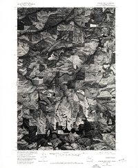
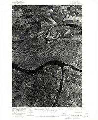
 1975 Pullman1977 Print · USGSThe Palouse hills of Whitman County appear in striking aerial detail during the mid-seventies. Researchers can trace the development of Pullman or locate rural landmarks near Staley and Johnson along the South Fork Palouse River.
 - 1975 Map of Clarkston, 1977 Print
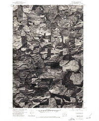
 1975 Clarkston1977 Print · USGSThe border towns of Washington and Idaho come into sharp focus in the mid-seventies, showing the urban footprint of Clarkston and Lewiston. Trace the residential grids of Lewiston Orchards and the confluence of the Snake River and Clearwater River.
End of results
Showing maps 1-5 of 5
Top cities of Whitman County
- Pullman historical maps
- Colfax historical maps
- Palouse historical maps
- Tekoa historical maps
- Rosalia historical maps
- Garfield historical maps
See more
Frequently asked questions
- What are the different types of historical maps available for Whitman County?
- What is the oldest map of Whitman County?
- Where can I purchase historical maps of Whitman County for my home or office?
- Where can I download high-res historical maps of Whitman County?
- Are there historical topographic maps available for Whitman County?
- Is there historical aerial imagery available for Whitman County?
- Where are historical maps of Whitman County sourced from?