1940s Maps of Whitman County, Washington
Explore 3 historic maps of Whitman County from the 1940s. These maps offer a rare glimpse into what life looked like during the 1940s — showing old roads, neighborhoods, homes, and landmarks that have changed or disappeared over time.
Whether you're researching your family's past, planning a metal detecting trip, or studying how Whitman County's landscape evolved across the 1940s, these high-resolution maps are a powerful tool for exploring the history of this region.
- Focus on a specific era: All maps on this page are from the 1940s, giving you a focused view of this time period.
- See what’s changed: Compare century-old streets, trails, and buildings to today's modern landscape using overlays and satellite layers.
- Research with precision: Use these maps for genealogy, historical research, land use analysis, or educational projects.
- View, download, or print: Maps are fully viewable online in high resolution, and can be downloaded or printed for your own records.
Start exploring Whitman County's history through authentic maps from the 1940s. This is your window into the past.
Whitman County, WA maps
(3)- 1945 Map of Clarkston, 1965 Print
 1945 Clarkston1965 Print · USGSThe Snake and Clearwater rivers meet in the mid-1940s, showing the early industrial growth of the border towns. Genealogists can trace family landmarks like Huggins Ranch and Stout Ranch or locate burials at Vineland Cem and Asotin Cem.
 - 1948 Map of Clarkston
 1948 Clarkston1948 Print · USGSSoutheast Washington and the Idaho border come alive in this post-war survey of the Snake and Clearwater river junction. Genealogists and local historians can trace family roots through sites like Vineland Cem, Huggins Ranch, and the early township of Asotin.
 - 1948 Map of Starbuck, 1968 Print
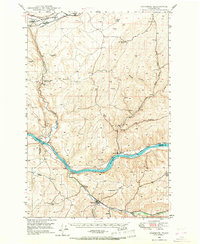 1948 Starbuck1968 Print · USGSThe Snake River canyon and Palouse coulees defined this rail-and-ranching corridor in the late 1940s. Genealogists and historians can trace the foundations of Starbuck, the riverside settlement of Riparia, and family sites like Gordon Farm.
End of results
Showing maps 1-3 of 3
Top cities of Whitman County
- Pullman historical maps
- Colfax historical maps
- Palouse historical maps
- Tekoa historical maps
- Rosalia historical maps
- Garfield historical maps
See more
Frequently asked questions
- What are the different types of historical maps available for Whitman County?
- What is the oldest map of Whitman County?
- Where can I purchase historical maps of Whitman County for my home or office?
- Where can I download high-res historical maps of Whitman County?
- Are there historical topographic maps available for Whitman County?
- Is there historical aerial imagery available for Whitman County?
- Where are historical maps of Whitman County sourced from?