Old Maps of Whitman County, Washington for Genealogy
Trace your family roots with 165 historic maps of Whitman County. These high-res maps reveal old neighborhoods, homesites, landmarks, and streets — helping you uncover where your ancestors lived and how the area evolved over time.
- Explore historic neighborhoods: Identify where your relatives may have lived in the 1800s or 1900s.
- Compare maps over time: Trace the changes in streets, buildings, and landmarks for multi-generational research.
- Perfect for genealogy & ancestry research: Used by family historians and researchers to map out lineage and migration.
These maps are an incredible resource for exploring your personal connection to Whitman County's past.
Whitman County, WA maps
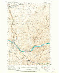
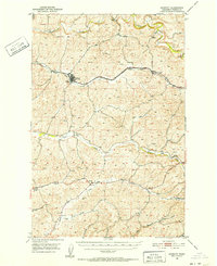
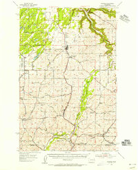
(165)- 1903 Map of Oakesdale
 1903 Oakesdale1903 Print · USGSThe Palouse and South Spokane regions are shown here at the height of the early railroad era. Researchers can trace family history through numerous small grain-stop settlements like Waverly, Latah, and Plaza, or locate family-named landmarks such as Steptoe Butte and Stratton Butte.
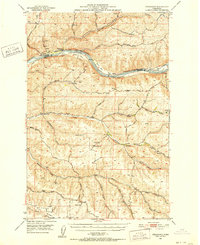
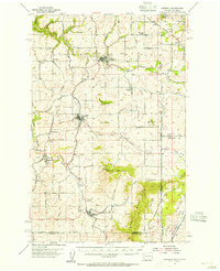
 - 1905 Map of Oakesdale
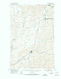
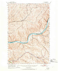
 1905 Oakesdale1905 Print · USGSEastern Washington at the dawn of the twentieth century was a landscape of burgeoning rail hubs and fertile Palouse hills. Genealogists and historians can trace the early layouts of Oakesdale, Tekoa, and Rosalia as they grew alongside the Northern Pacific RR.3 unique versions available
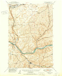
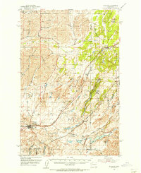
 - 1910 Map of Pullman
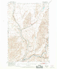
 1910 Pullman1910 Print · USGSThe Palouse hills and Snake River breaks are shown here in the early twentieth century, during a period of rapid railway expansion and academic growth. Genealogists and historians can trace the early layouts of Pullman and Colfax, as well as rural post offices like Guy Albion PO and the campus of the State College of Washington.5 unique versions available
 - 1945 Map of Clarkston, 1965 Print
 1945 Clarkston1965 Print · USGSThe Snake and Clearwater rivers meet in the mid-1940s, showing the early industrial growth of the border towns. Genealogists can trace family landmarks like Huggins Ranch and Stout Ranch or locate burials at Vineland Cem and Asotin Cem.
 - 1948 Map of Clarkston
 1948 Clarkston1948 Print · USGSSoutheast Washington and the Idaho border come alive in this post-war survey of the Snake and Clearwater river junction. Genealogists and local historians can trace family roots through sites like Vineland Cem, Huggins Ranch, and the early township of Asotin.
 - 1948 Map of Starbuck, 1968 Print
 1948 Starbuck1968 Print · USGSThe Snake River canyon and Palouse coulees defined this rail-and-ranching corridor in the late 1940s. Genealogists and historians can trace the foundations of Starbuck, the riverside settlement of Riparia, and family sites like Gordon Farm.
 - 1950 Map of La Crosse
 1950 La Crosse1950 Print · USGSWhitman County's wheat-growing heartland is captured here in the mid-twentieth century as the rail-and-river economy flourished. You can trace the Union Pacific line through Winona and La Crosse, or locate rural landmarks like Pampa Pond and the Airway Beacon.2 unique versions available
 - 1950 Map of Starbuck
 1950 Starbuck1950 Print · USGSSoutheast Washington during the late 1940s is defined by the winding Snake River and its rugged canyons. Genealogists and historians can trace the rail-and-river network of Starbuck and Riparia, or locate family sites like Gordon Farm and McGregor Ranch.
 - 1950 Map of Penawawa, 1952 Print
 1950 Penawawa1952 Print · USGSIn the early 1950s, the Snake River still flowed freely past small riverside settlements and across numerous bars. Genealogists can trace family names and vanished locales such as Penawawa, Gould City, and Rice Bar along the Union Pacific line.2 unique versions available
 - 1950 Map of Endicott, 1952 Print
 1950 Endicott1952 Print · USGSWhitman County's wheat country is captured in the early fifties, showing the rural rail-and-creek network that sustained the Palouse. Researchers can locate the Union Pacific line, the small settlement of Dusty, and local landmarks like Lacrosse Grange.3 unique versions available
 - 1950 Map of Hay, 1956 Print
 1950 Hay1956 Print · USGSWhitman and Garfield counties are captured here in the mid-twentieth century as the regional economy revolved around the Snake River and its rail corridors. Genealogists and local historians can locate rural landmarks like the Selbu Church, the Pataha Valley Grange, and the Central Ferry crossing.2 unique versions available
 - 1950 Map of Benge, 1970 Print
 1950 Benge1970 Print · USGSThe scabland coulees and rail corridors of Adams County are captured here in the mid-twentieth century. Researchers can trace the Old Military Trail or locate the rural hubs of Benge, Ankeny, and Hooper along the river and rail lines.2 unique versions available
 - 1952 Map of Hay
 1952 Hay1952 Print · USGSThe Snake River corridor in the early fifties shows a landscape of isolated ferry crossings and canyon-side rail lines. Genealogists can locate family landmarks like Selbu Church, the Pataha Valley Grange, and the old Central Ferry School.
 - 1952 Map of La Crosse
 1952 La Crosse1952 Print · USGSWhitman County's Palouse hills and deep creek flats are captured here in the early fifties, showing a landscape shaped by water and rail. Genealogists and rail historians can trace the Union Pacific line through La Crosse, Winona, and the small siding at Pampa.
 - 1952 Map of Benge
 1952 Benge1952 Print · USGSThe scablands of Adams and Whitman counties are captured here in the early fifties, showing a landscape shaped by rail and river. Genealogists and rail historians can trace the tracks through Benge, Hooper, and Ankeny along the banks of the Palouse River.
 - 1953 Map of Walla Walla, 1964 Print
 1953 Walla Walla1964 Print · USGSSoutheast Washington enters the atomic and hydroelectric age in the mid-twentieth century as new dams reshape the desert landscape. You can trace the development of the Hanford Works, identify remote rail stops like Novara Siding, and locate the historic Dry Creek Cem.3 unique versions available
 - 1954 Map of Cheney, 1956 Print
 1954 Cheney1956 Print · USGSEastern Washington in the mid-fifties is captured here as a major railroad junction and home to the Eastern Washington College of Education. Genealogists and historians can trace defunct rural sites like the Harmony School or find family landmarks near Williams Lake and Fairview Cemetery.3 unique versions available
 - 1954 Map of Spangle, 1956 Print
 1954 Spangle1956 Print · USGSSoutheast of Spokane in the 1950s, this area reveals a dense network of early Pacific Northwest rail lines and fading rural school districts. Researchers can find grain elevators along the Great Northern and trace defunct sites like Buckeye Sch (Aband).2 unique versions available
 - 1954 Map of Sprague, 1956 Print
 1954 Sprague1956 Print · USGSEastern Washington’s Channeled Scablands are captured in the mid-1950s, showing a complex network of four major railroads crossing the rocky terrain. Genealogists and rail historians can trace the foundations of Sprague, the community at Fishtrap, and the Aban'd Sch near Tyler.2 unique versions available
 - 1954 Map of Fairfield, 1956 Print
 1954 Fairfield1956 Print · USGSEastern Washington's agricultural heartland is documented here in the mid-fifties, featuring a dense network of rail lines and grain-country settlements. Trace the routes of the Union Pacific and visit sites like Fairfield, Latah, and the McIntosh Grange.3 unique versions available
 - 1955 Map of Pullman, 1963 Print
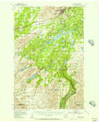
 1955 Pullman1963 Print · USGSThe Palouse and Clearwater regions are captured here in the mid-1950s, showing the height of the rail-and-river economy. Genealogists and historians can trace rail lines like the Camas Prairie RR, find local landmarks like Whitman County Memorial Cem, and locate early academic centers at Washington State University and the University of Idaho.3 unique versions available
 - 1955 Map of Spokane, 1965 Print
 1955 Spokane1965 Print · USGSInland Empire life in the fifties and sixties centers on the growth of Spokane and the heavy mining industry of northern Idaho. Trace mid-century landmarks like Fairchild Air Force Base, the Bunker Hill Mine, and early campuses such as Gonzaga University.2 unique versions available
 - 1958 Map of Spokane
 1958 Spokane1958 Print · USGSThe Inland Empire is shown at a mid-century peak of industrial and military activity, from the rail hubs of Spokane to the deep silver mines of northern Idaho. Researchers can trace the sprawling rail lines of the Union Pacific RR or locate landmarks like Fairchild Air Force Base and the Bunker Hill Smelter & Mine.
 - 1958 Map of Pullman
 1958 Pullman1958 Print · USGSThe Palouse and Clearwater regions are captured here in the late fifties, showing the vital river-and-rail connection between eastern Washington and northern Idaho. Local historians can trace the paths of the Camas Prairie RR and Union Pacific RR as they serve towns like Colfax, Kamiah, and Nezperce.2 unique versions available
 - 1958 Map of Walla Walla
 1958 Walla Walla1958 Print · USGSThe Tri-Cities and Walla Walla region are captured here during the mid-century expansion of atomic energy and river infrastructure. Genealogists and historians can trace the early layout of Richland (AEC), the rural Hatton and Washtucna settlements, and landmarks like Palouse Falls State Park.
Showing maps 1-25 of 165
Top cities of Whitman County
- Pullman historical maps
- Colfax historical maps
- Palouse historical maps
- Tekoa historical maps
- Rosalia historical maps
- Garfield historical maps
See more
Frequently asked questions
- What are the different types of historical maps available for Whitman County?
- What is the oldest map of Whitman County?
- Where can I purchase historical maps of Whitman County for my home or office?
- Where can I download high-res historical maps of Whitman County?
- Are there historical topographic maps available for Whitman County?
- Is there historical aerial imagery available for Whitman County?
- Where are historical maps of Whitman County sourced from?