1940s Maps of Hampshire County, West Virginia
Explore 5 historic maps of Hampshire County from the 1940s. These maps offer a rare glimpse into what life looked like during the 1940s — showing old roads, neighborhoods, homes, and landmarks that have changed or disappeared over time.
Whether you're researching your family's past, planning a metal detecting trip, or studying how Hampshire County's landscape evolved across the 1940s, these high-resolution maps are a powerful tool for exploring the history of this region.
- Focus on a specific era: All maps on this page are from the 1940s, giving you a focused view of this time period.
- See what’s changed: Compare century-old streets, trails, and buildings to today's modern landscape using overlays and satellite layers.
- Research with precision: Use these maps for genealogy, historical research, land use analysis, or educational projects.
- View, download, or print: Maps are fully viewable online in high resolution, and can be downloaded or printed for your own records.
Start exploring Hampshire County's history through authentic maps from the 1940s. This is your window into the past.
Hampshire County, WV maps
(5)- 1943 Map of Capon Bridge
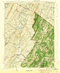 1943 Capon Bridge1943 Print · USGSHampshire and Frederick Counties appear in the early 1940s as a landscape of winding mountain rivers and quiet ridge-top settlements. Researchers can trace historic family landmarks and community hubs like Capon Chapel, the Northwestern Turnpike, and Forks of Cacapon.2 unique versions available
 - 1943 Map of Middletown
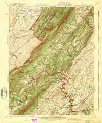 1943 Middletown1943 Print · USGSThe Virginia and West Virginia borderlands are revealed in this wartime-era survey of Frederick County and the surrounding ridges. Genealogists and historians can trace family locations near Star Tannery, the Cedar Creek Battlefield, or old schoolhouses like Mountain View Sch.2 unique versions available
 - 1945 Map of Moorefield
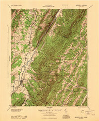 1945 Moorefield1945 Print · USGSHardy and Hampshire counties at the close of World War II reveal a landscape defined by the Potomac river-and-rail economy. Genealogists can locate family landmarks like Reynolds Gap and rural centers such as Old Pine Ch and Bethel Sch.
 - 1948 Map of Cumberland
 1948 Cumberland1948 Print · USGSMid-century Appalachia and the Shenandoah Valley are shown in detail, documenting the industrial and transportation hubs of the tri-state area. Genealogists can trace family roots through settlements like Double Tollgate and Bunker Hill or along the Baltimore & Ohio RR.3 unique versions available
 - 1949 Map of Patterson Creek, 1963 Print
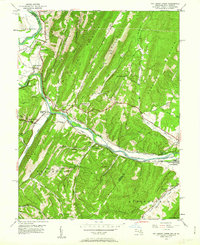 1949 Patterson Creek1963 Print · USGSThe Potomac River valley on the Maryland-West Virginia border is captured here during the late 1940s, showing a landscape shaped by rail and river transport. Genealogists and historians can trace the Chesapeake and Ohio Canal (Abandoned) past rural sites like Mt Tabor Ch and St Marys Cem.3 unique versions available
End of results
Showing maps 1-5 of 5
Top cities of Hampshire County
Frequently asked questions
- What are the different types of historical maps available for Hampshire County?
- What is the oldest map of Hampshire County?
- Where can I purchase historical maps of Hampshire County for my home or office?
- Where can I download high-res historical maps of Hampshire County?
- Are there historical topographic maps available for Hampshire County?
- Is there historical aerial imagery available for Hampshire County?
- Where are historical maps of Hampshire County sourced from?